
Edmond Island facts for kids

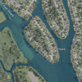
USGS aerial imagery of Edmond Island
|
|

Edmond Island
Location in Wayne County, Michigan

Edmond Island
Location in Michigan

Edmond Island
Location in the United States
|
|
| Geography | |
|---|---|
| Location | Michigan |
| Coordinates | 42°04′58″N 83°11′39″W / 42.08278°N 83.19417°W |
| Highest elevation | 577 ft (175.9 m) |
| Administration | |
|
United States
|
|
| State | |
| County | Wayne |
Edmond Island is a small piece of land in the Detroit River. This island is located in the city of Gibraltar, which is in the state of Michigan, United States.
Contents
Where is Edmond Island Located?
Edmond Island is found in the lower part of the Detroit River. This river connects Lake Erie and Lake St. Clair. The island is part of Wayne County, Michigan.
Understanding its Coordinates
The exact location of Edmond Island can be pinpointed using special numbers called coordinates. These are 42°04′58″N 83°11′39″W / 42.08278°N 83.19417°W. The "N" means North latitude, and "W" means West longitude. These numbers help maps show exactly where the island is.
How High is Edmond Island?
The United States Geological Survey (USGS) has measured the height of Edmond Island. Its elevation is about 577 feet (or 176 meters) above sea level. This measurement helps us understand how high the land is compared to the ocean.
Images for kids
-
USGS aerial imagery of Edmond Island
