
Eglinton Island facts for kids

Closeup of Eglinton Island
|
|

Eglinton Island, Northwest Territories
|
|

Eglinton Island
Location in Northwest Territories

Eglinton Island
Location in Canada
|
|
| Geography | |
|---|---|
| Location | Northern Canada |
| Coordinates | 75°46′N 118°27′W / 75.767°N 118.450°W |
| Archipelago | Queen Elizabeth Islands Canadian Arctic Archipelago |
| Area | 1,541 km2 (595 sq mi) |
| Length | 73 km (45.4 mi) |
| Width | 44 km (27.3 mi) |
| Administration | |
|
Canada
|
|
| Territory | Northwest Territories |
| Demographics | |
| Population | Uninhabited |
Eglinton Island is a quiet, empty island in the far north of Canada. It's part of the Canadian Arctic Archipelago, which is a huge group of islands. This island is also one of the Queen Elizabeth Islands.
Eglinton Island is located in the Northwest Territories of Canada. It sits at about 75° North and 118° West. The island covers an area of about 1,541 square kilometers (595 square miles). It is about 73 kilometers (45 miles) long and 44 kilometers (27 miles) wide.
The island is found on the north side of the M'Clure Strait. It is just south of a much larger island called Prince Patrick Island. Eglinton Island has no people living on it, and there is no known human activity there.
Discovery of Eglinton Island
The first time a European saw Eglinton Island was in 1853. This sighting was made by a person named George Mecham. Later that same spring, George Mecham and Francis Leopold McClintock explored the island.
Images for kids
-
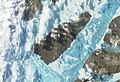
A satellite image of Eglinton Island from Terra/MODIS.
-
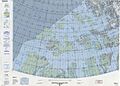
A map that includes Eglinton Island.


See also
 In Spanish: Isla Eglinton para niños
