Egozcue facts for kids
Quick facts for kids
Egozcue
|
|
|---|---|
|
Barrio
|
|

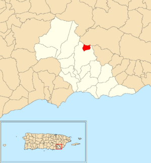
Location of Egozcue within the municipality of Patillas shown in red
|
|
| Commonwealth | |
| Municipality | |
| Area | |
| • Total | 0.48 sq mi (1.2 km2) |
| • Land | 0.48 sq mi (1.2 km2) |
| • Water | 0 sq mi (0 km2) |
| Elevation | 1,450 ft (440 m) |
| Population
(2010)
|
|
| • Total | 52 |
| • Density | 108.3/sq mi (41.8/km2) |
| Source: 2010 Census | |
| Time zone | UTC−4 (AST) |
Egozcue is a small community, or barrio, located in the municipality of Patillas, Puerto Rico. In 2010, only 52 people lived there, making it a very quiet place.
Egozcue's Population History
The number of people living in Egozcue has changed a lot over the years. In 1910, there were 229 residents. The population grew to its highest point in 1920, with 323 people.
After 1920, the population started to decrease. By 1950, only 105 people lived in Egozcue. In recent times, the population has remained quite small. Both the 2000 and 2010 censuses recorded 52 residents.
Understanding Sectors in Egozcue
In Puerto Rico, a barrio like Egozcue is often divided into smaller areas called sectores. Think of sectores as neighborhoods or smaller parts of a larger community. These smaller areas help organize the barrio.
Egozcue barrio includes several sectores. These are:
- Carretera 181
- Carretera 7759
- Sector Betancourt
- Sector Calanse
- Sector Campusu
- Sector Cuatro Calles
- Sector El Coquí
- Sector Guaraguao
- Sector Huertas
- Sector Pedragón
See also
 In Spanish: Egozcue (Patillas) para niños
- List of communities in Puerto Rico
- List of barrios and sectors of Patillas, Puerto Rico
 | Tommie Smith |
 | Simone Manuel |
 | Shani Davis |
 | Simone Biles |
 | Alice Coachman |


