Eighty Four, Pennsylvania facts for kids
Quick facts for kids
Eighty Four, Pennsylvania
|
|
|---|---|

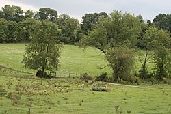
Countryside in Eighty Four, Pennsylvania
|
|
| Country | United States |
| State | Pennsylvania |
| County | Washington |
| Area | |
| • Total | 6.60 sq mi (17.10 km2) |
| • Land | 6.60 sq mi (17.10 km2) |
| • Water | 0.00 sq mi (0.00 km2) |
| Elevation | 1,049 ft (320 m) |
| Population
(2020)
|
|
| • Total | 645 |
| • Density | 97.71/sq mi (37.73/km2) |
| Time zone | UTC-5 (Eastern (EST)) |
| • Summer (DST) | UTC-4 (EDT) |
| ZIP Codes |
15330
|
| Area code(s) | 724 |
| FIPS code | 42-22736 |
| GNIS feature ID | 1174062 |
Eighty Four is a small community in Washington County, Pennsylvania. It's known as a census-designated place, which means it's a special area identified by the government for counting people. Eighty Four is about 25 miles (40 km) southwest of Pittsburgh, a major city in Pennsylvania.
In 2020, about 645 people lived in Eighty Four. This community is home to the main office of the 84 Lumber company. Students in Eighty Four attend schools in several different districts, including Canon-McMillan, Trinity, Ringgold, and Bentworth.
Getting to Eighty Four is easy! You can use PA Route 519 and PA Route 136. It's also close to major highways like Interstate 79 and Interstate 70. If you're flying, the closest big airport is Pittsburgh International Airport. It's about 25 miles northwest of Eighty Four.
| Historical population | |||
|---|---|---|---|
| Census | Pop. | %± | |
| 2020 | 645 | — | |
| U.S. Decennial Census | |||
Why is it Called Eighty Four?
The name of this town is quite unique! Eighty Four was not always called that. It was first known as Smithville. However, there was another town with the same name, which caused confusion for the postal service. So, on July 28, 1884, the name was officially changed to "Eighty Four."
The exact reason for the name "Eighty Four" isn't completely clear, but there are a few ideas:
- Some people thought it was named after Grover Cleveland's election as President of the United States in 1884. But the town was named before he won the election.
- Another idea is that the town was named after a mile marker on the Baltimore and Ohio Railroad. This marker might have shown the distance as "84."
- A simpler idea is that the town's post office was built in 1884. Maybe the postmaster at the time just used the year as the new name!
See also
 In Spanish: Eighty Four para niños
 | Roy Wilkins |
 | John Lewis |
 | Linda Carol Brown |


