Eileanan Chearabhaigh facts for kids
| Gaelic name | Eileanan Chearabhaigh |
|---|---|
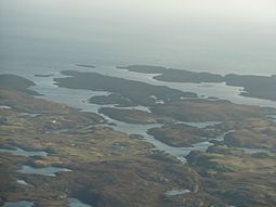
 The islands of Eileanan Chearabhaigh at centre, with mainland Benbecula in the foreground and the northern tip of Wiay beyond |
|
| OS grid reference | NF866476 |
| Coordinates | 57°25′N 7°13′W / 57.41°N 7.22°W |
| Physical geography | |
| Island group | Uist |
| Area | 49 hectares (120 acres) |
| Highest elevation | c. 23 metres (75 ft) |
| Administration | |
| Sovereign state | United Kingdom |
| Country | Scotland |
| Council area | Comhairle nan Eilean Siar |
Eileanan Chearabhaigh (pronounced Eye-lan-an Ker-a-vay) is a collection of small, empty islands. They are found off the southeast coast of Benbecula in the Outer Hebrides of Scotland. These islands are special because they are "tidal islands." This means their shape and connection to the land change with the ocean's tides. Sometimes, people also call them the Keiravagh Islands.
Discovering Eileanan Chearabhaigh
Eileanan Chearabhaigh is a fascinating group of small islands. They are located near Benbecula in the Outer Hebrides of Scotland. The islands are uninhabited, meaning no one lives on them. Their name, Eileanan Chearabhaigh, comes from the Scottish Gaelic language. Sometimes, you might hear them called the Keiravagh Islands in English.
What are Tidal Islands?
These islands are a great example of "tidal islands." This means their size and shape change with the ocean tides. At low tide, the islands connect to Benbecula by sand. They form a larger area of about 50 hectares (124 acres). This makes them look like a peninsula, which is land almost surrounded by water.
However, at high tide, the water covers the sandy connection. The islands then become separate from Benbecula. They turn into many small islets stretching for over 2 kilometers (1.2 miles) from east to west. The largest of these islets is about 31 hectares (77 acres).
Exploring the Area
The waters around Eileanan Chearabhaigh are very active. To the north, you'll find Loch Chearabhaigh. To the south, there is Loch a' Laip. These are tidal lochs, meaning they are connected to the sea.
The nearby island of Wiay is also uninhabited and lies to the south. The waters in Loch a' Laip and Loch Chearabhaigh are good for fish farming. This means people raise fish there for food.
Loch a' Laip also offers a safe place for boats to stop. However, the area has many rocks and small rocky islands called skerries. It's important to be careful when sailing here.
There are piers on Benbecula near Eileanan Chearabhaigh. One is at the western end of the islands, and another is to the south at Eilean na Cille. These piers are useful for boats, but it's best to have local knowledge before using them. This is because the waters can be tricky to navigate.
 | Lonnie Johnson |
 | Granville Woods |
 | Lewis Howard Latimer |
 | James West |

