Ekalaka, Montana facts for kids
Quick facts for kids
Ekalaka, Montana
|
|
|---|---|

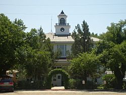
Carter County Courthouse
|
|

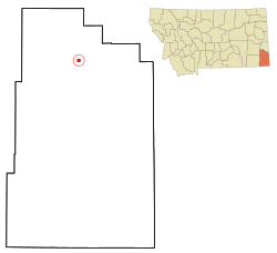
Location of Ekalaka, Montana
|
|
| Country | United States |
| State | Montana |
| County | Carter |
| Area | |
| • Total | 1.03 sq mi (2.67 km2) |
| • Land | 1.03 sq mi (2.67 km2) |
| • Water | 0.00 sq mi (0.00 km2) |
| Elevation | 3,425 ft (1,044 m) |
| Population
(2020)
|
|
| • Total | 399 |
| • Density | 387.76/sq mi (149.64/km2) |
| Time zone | UTC-7 (Mountain (MST)) |
| • Summer (DST) | UTC-6 (MDT) |
| ZIP code |
59324
|
| Area code(s) | 406 |
| FIPS code | 30-23650 |
| GNIS feature ID | 2412470 |
Ekalaka is a small town in Montana, United States. It's the main town, or county seat, of Carter County. In 2020, about 399 people lived there.
Contents
History of Ekalaka
Ekalaka got its name from a Sioux girl named Ijkalaka. She was the wife of a scout named David Harrison Russell.
Ijkalaka, whose name means "Restless" or "Moving About," was from the Oglala Lakota people. She was born in 1858 near the Powder River. She met David Russell when she was 16 years old.
David Russell created the town of Ekalaka next to his ranch. In 1885, a man named Carter got stuck in the mud nearby and decided to open a saloon. He is famous for saying, "Anyplace in Montana is a good place to open a saloon." Soon, the area became a busy trading spot for cattle ranchers and sheepherders. Russell built houses for freight workers and hunters, and more people moved in.
Geography and Climate
Ekalaka is located in a unique area of Montana. The town covers about 1.04 square miles (2.67 square kilometers) of land.
The area around Ekalaka is known for its sandstone rocks and wide-open plains. The Custer National Forest is also nearby. A small stream called Russell Creek flows through the town.
Weather in Ekalaka
Ekalaka has a dry continental climate. This means it has cold, dry winters and hot, wetter summers.
| Climate data for Ekalaka, Montana, 1991–2020 normals, extremes 1896–present | |||||||||||||
|---|---|---|---|---|---|---|---|---|---|---|---|---|---|
| Month | Jan | Feb | Mar | Apr | May | Jun | Jul | Aug | Sep | Oct | Nov | Dec | Year |
| Record high °F (°C) | 65 (18) |
66 (19) |
83 (28) |
90 (32) |
98 (37) |
105 (41) |
108 (42) |
108 (42) |
103 (39) |
92 (33) |
78 (26) |
67 (19) |
108 (42) |
| Mean maximum °F (°C) | 51.6 (10.9) |
53.8 (12.1) |
66.9 (19.4) |
75.9 (24.4) |
82.9 (28.3) |
90.4 (32.4) |
96.3 (35.7) |
94.8 (34.9) |
90.8 (32.7) |
79.0 (26.1) |
64.3 (17.9) |
52.8 (11.6) |
98.0 (36.7) |
| Mean daily maximum °F (°C) | 32.5 (0.3) |
35.0 (1.7) |
46.4 (8.0) |
56.8 (13.8) |
66.8 (19.3) |
76.5 (24.7) |
85.6 (29.8) |
84.7 (29.3) |
74.5 (23.6) |
58.4 (14.7) |
44.0 (6.7) |
34.3 (1.3) |
58.0 (14.4) |
| Daily mean °F (°C) | 21.6 (−5.8) |
24.0 (−4.4) |
34.1 (1.2) |
43.7 (6.5) |
53.6 (12.0) |
63.2 (17.3) |
71.2 (21.8) |
70.0 (21.1) |
60.0 (15.6) |
45.8 (7.7) |
32.8 (0.4) |
23.6 (−4.7) |
45.3 (7.4) |
| Mean daily minimum °F (°C) | 10.8 (−11.8) |
13.1 (−10.5) |
21.8 (−5.7) |
30.7 (−0.7) |
40.4 (4.7) |
49.9 (9.9) |
56.8 (13.8) |
55.3 (12.9) |
45.6 (7.6) |
33.2 (0.7) |
21.5 (−5.8) |
12.9 (−10.6) |
32.7 (0.4) |
| Mean minimum °F (°C) | −17.3 (−27.4) |
−11.6 (−24.2) |
−3.4 (−19.7) |
12.6 (−10.8) |
24.3 (−4.3) |
36.8 (2.7) |
44.5 (6.9) |
40.2 (4.6) |
29.4 (−1.4) |
12.8 (−10.7) |
−2.4 (−19.1) |
−13.3 (−25.2) |
−24.1 (−31.2) |
| Record low °F (°C) | −44 (−42) |
−43 (−42) |
−32 (−36) |
−11 (−24) |
8 (−13) |
27 (−3) |
30 (−1) |
26 (−3) |
13 (−11) |
−15 (−26) |
−30 (−34) |
−43 (−42) |
−44 (−42) |
| Average precipitation inches (mm) | 0.58 (15) |
0.66 (17) |
0.95 (24) |
1.86 (47) |
3.21 (82) |
2.95 (75) |
2.10 (53) |
1.35 (34) |
1.60 (41) |
1.58 (40) |
0.76 (19) |
0.51 (13) |
18.11 (460) |
| Average snowfall inches (cm) | 6.5 (17) |
9.0 (23) |
8.8 (22) |
5.3 (13) |
2.6 (6.6) |
0.0 (0.0) |
0.0 (0.0) |
0.0 (0.0) |
0.1 (0.25) |
2.4 (6.1) |
6.2 (16) |
7.5 (19) |
48.4 (122.95) |
| Average precipitation days (≥ 0.01 in) | 7.4 | 7.2 | 7.4 | 8.4 | 11.3 | 10.7 | 7.9 | 6.7 | 6.5 | 8.0 | 6.7 | 7.1 | 95.3 |
| Average snowy days (≥ 0.1 in) | 6.6 | 6.8 | 4.9 | 2.2 | 0.7 | 0.0 | 0.0 | 0.0 | 0.1 | 1.6 | 4.4 | 6.7 | 34.0 |
| Source 1: NOAA | |||||||||||||
| Source 2: National Weather Service | |||||||||||||
People of Ekalaka
| Historical population | |||
|---|---|---|---|
| Census | Pop. | %± | |
| 1920 | 433 | — | |
| 1930 | 475 | 9.7% | |
| 1940 | 719 | 51.4% | |
| 1950 | 904 | 25.7% | |
| 1960 | 738 | −18.4% | |
| 1970 | 663 | −10.2% | |
| 1980 | 620 | −6.5% | |
| 1990 | 439 | −29.2% | |
| 2000 | 410 | −6.6% | |
| 2010 | 332 | −19.0% | |
| 2020 | 399 | 20.2% | |
| U.S. Decennial Census | |||
In 2010, there were 332 people living in Ekalaka. Most residents were White (96.4%). A small number were Native American or from other backgrounds.
The average age of people in Ekalaka was 54 years old. About 15% of the residents were under 18. Many people living alone were 65 or older.
Arts and Culture
Ekalaka is a cool place for dinosaur fans! It's part of the Montana Dinosaur Trail. The Carter County Museum in Ekalaka is famous for its amazing collection of dinosaur fossils.
A prehistoric bird, Magnusavis ekalakaensis, was even named after the town because of discoveries made nearby.
The Ekalaka Public Library serves the town, offering books and resources for everyone.
Education in Ekalaka
Students in Ekalaka go to Ekalaka Public Schools. This includes Ekalaka Elementary District for younger kids and Carter County High School for older students. The school teams are known as the Bulldogs!
Local Media
The Ekalaka Eagle is the local newspaper for Carter County. It comes out every week, both in print and online, keeping everyone updated on town news.
Transportation and Roads
Ekalaka is an important spot for roads. Montana Highway 7 starts here and goes north. Montana Secondary Highway 323 ends here, coming from the south.
The town also has its own airport, Ekalaka Airport. It's located just 2 miles southeast of town and is open for public use.
Notable Person
- Bertha Berry, a pioneering nurse who helped many people in Ekalaka.
See also
 In Spanish: Ekalaka (Montana) para niños
 | George Robert Carruthers |
 | Patricia Bath |
 | Jan Ernst Matzeliger |
 | Alexander Miles |

