El Capitan, Arizona facts for kids
Quick facts for kids
El Capitan, Arizona
|
|
|---|---|

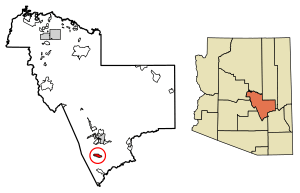
Location of El Capitan in Gila County, Arizona.
|
|
| Country | United States |
| State | Arizona |
| County | Gila |
| Area | |
| • Total | 6.09 sq mi (15.78 km2) |
| • Land | 6.09 sq mi (15.78 km2) |
| • Water | 0.00 sq mi (0.00 km2) |
| Elevation | 6,568 ft (2,002 m) |
| Population
(2020)
|
|
| • Total | 48 |
| • Density | 7.88/sq mi (3.04/km2) |
| Time zone | UTC-7 (Mountain (MST)) |
| ZIP code |
85192
|
| Area code(s) | 928 |
| GNIS feature ID | 2582779 |
El Capitan is a small community located in Gila County, in the U.S. state of Arizona. It is known as a census-designated place, which means it's an area identified by the U.S. Census Bureau for collecting statistics. However, it does not have its own local government like a city or town.
El Capitan is about 13 miles south of the city of Globe. In 2020, 48 people lived there.
Geography of El Capitan
El Capitan is found at specific geographic coordinates. These are 33.238343 degrees North latitude and 110.783288 degrees West longitude.
According to the U.S. Census Bureau, the community covers an area of about 6.08 square miles (15.78 square kilometers). All of this area is land, with no water.
Population and People
How Many People Live in El Capitan?
The study of how many people live in a place is called demographics. The population of El Capitan has changed over time.
| Historical population | |||
|---|---|---|---|
| Census | Pop. | %± | |
| 2020 | 48 | — | |
| U.S. Decennial Census | |||
In 2010, the U.S. Census counted 37 people living in El Capitan. By the 2020 U.S. Census, the population had grown slightly to 48 people.
See also
 In Spanish: El Capitán (Arizona) para niños
 | John T. Biggers |
 | Thomas Blackshear |
 | Mark Bradford |
 | Beverly Buchanan |


