El Jorullo facts for kids
Quick facts for kids El Jorullo |
|
|---|---|

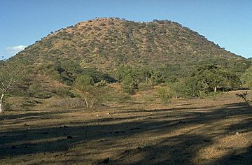
El Jorullo cinder cone
|
|
| Highest point | |
| Elevation | 1,330 m (4,360 ft) |
| Geography | |
| Location | La Huacana, Michoacán, Mexico |
| Geology | |
| Mountain type | cinder cone |
| Last eruption | 1759–1774 |
| Climbing | |
| Easiest route | Hike |
El Jorullo is a cinder cone volcano located in Michoacán, a state in central Mexico. It sits on the southwest side of Mexico's central plateau. This volcano is part of a larger area called the Michoacán-Guanajuato volcanic field.
El Jorullo is about 53 kilometers (33 miles) southeast of Uruapan. It is also about 10 kilometers (6 miles) east-northeast of La Huacana. The top of El Jorullo is currently about 1,330 meters (4,360 feet) high. It has four smaller cinder cones that have grown on its sides. The openings where lava comes out, called vents, line up from northeast to southwest. Lava from these vents covers about nine square kilometers (3.5 square miles) around the volcano.
Contents
Mexico's Young Volcanoes
El Jorullo is one of only two volcanoes known to have formed in Mexico in recent history. The other volcano is named Parícutin. Parícutin was born about 183 years after El Jorullo. It eventually destroyed a nearby village. Parícutin is located about 80 kilometers (50 miles) northwest of El Jorullo.
When El Jorullo First Erupted
El Jorullo first erupted on September 29, 1759. Before the eruption began, there were several earthquakes. Once the volcano started erupting, it continued for 15 years! The eruptions finally stopped in 1774. This was the longest eruption known for a cinder cone volcano.
Lava Flows and Ash Falls
The early eruptions from El Jorullo produced sticky mud flows, water flows, and ash falls. These covered the area around the volcano. Later eruptions were different. They produced thicker lava that did not have mud or water flows. You can still see lava flows to the north and west of the volcano today.
Explorer Alexander von Humboldt's Visit
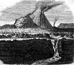
Alexander von Humboldt was a famous scientist and explorer. He climbed El Jorullo during his scientific trip to Spanish America. He visited the volcano on September 19, 1803. At that time, the volcano's many cones were still smoking. The air was very hot and full of volcanic gases.
Humboldt's Detailed Description
Humboldt wrote a detailed story about his climb. He noted that his face and the faces of his travel friends got burned by the heat. He also saw that the volcano had made the local soil very rich. Because of this, there was a lot of plant life growing there. Humboldt drew a picture of the volcano from a distance. His drawing showed its many smoking cones.
Humboldt climbed with his science partner, Aimé Bonpland. A local settler named Ramón Epelde also joined them. Two local helpers, whose names are not known, also assisted them. Humboldt thanked them for their help. He also mentioned that he used information from a book written in 1782 by Rafael Landívar. This book had calculated the volcano's height and the temperature of its hot springs.
Impact on the Land
El Jorullo did not start in a corn field like Parícutin did. However, it did destroy what used to be a rich farming area. In its first six weeks, the volcano grew about 250 meters (820 feet) from the ground.
The Trans-Mexican Volcanic Belt
Both Parícutin and El Jorullo are located in an area famous for its volcanoes. This region is called the Trans-Mexican Volcanic Belt. It stretches about 1,100 kilometers (700 miles) from east to west across southern Mexico.
A Fertile and Populous Region
Volcanic activity in this belt has left a layer of volcanic rock about 1,800 meters (6,000 feet) thick. This has created a high and fertile plateau. During the summer, the high areas catch moisture-filled breezes from the Pacific Ocean. This makes the land rich for farming. Because of the good farmland, this belt is the most populated region in Mexico. It is home to three of Mexico's four largest cities: Mexico City, Puebla, and Guadalajara.
In the early 1940s, the area around Parícutin was still a quiet place. It was inhabited by the Purépecha people. Today, you can reach the crater and a lake by car.
See also
- List of volcanoes in Mexico
 In Spanish: El Jorullo para niños
 | Isaac Myers |
 | D. Hamilton Jackson |
 | A. Philip Randolph |


