
El Yunque (Puerto Rico) facts for kids
Quick facts for kids El Yunque |
|
|---|---|

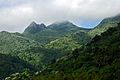
View of El Yunque from the Yokahú Tower in Río Grande, Puerto Rico
|
|
| Highest point | |
| Elevation | 1,080 m (3,540 ft) |
| Parent peak | El Toro |
| Naming | |
| Etymology | Yúcahu phonetic Spanish transliteration of Taíno possibly meaning 'white land' and/or El Yunque meaning 'the anvil' in Spanish due to the shape of the mountain range when seen from the south. |
| Geography | |

El Yunque
Location in Puerto Rico
|
|
| Parent range | Sierra de Luquillo |
| Climbing | |
| Easiest route | Hike |
El Yunque, also known as El Yunque Peak, is a famous mountain in Puerto Rico. Its name comes from Spanish, meaning 'the anvil,' or from the Taíno word Yukiyu. This mountain is special because it's part of the El Yunque National Forest. This forest is the only tropical rainforest managed by the U.S. Forest Service. You can find El Yunque in the town of Río Grande.
Contents
Discovering El Yunque Peak


El Yunque Peak stands about 1,080 meters (3,543 feet) above sea level. It is not the tallest mountain in Puerto Rico. However, it is the most well-known peak. People love it for its unique shape and beautiful natural surroundings. It also has a rich history and is very important to the Taíno people.
The peak is almost always covered in a light mist. Because of the high humidity, a quick rain shower often happens in the afternoons. Hiking to the top from Mina Falls is not too hard. It usually takes about four and a half hours.
Other Peaks in the Area
El Yunque Peak is part of a larger mountain area called the El Yunque massif. This area includes other smaller peaks. Some of these are Mount Britton, Juan Diego Peak, and Roca del Yunque. Roca del Yunque is a rocky peak close to the summit of El Yunque. The entire El Yunque massif is part of the Sierra de Luquillo mountain range.
The highest point in the Sierra de Luquillo is El Toro. Its name means 'the bull' in Spanish. El Toro is located between the towns of Río Grande and Las Piedras. It also gives its name to the El Toro Wilderness area.
El Yunque's Climate
El Yunque has a tropical rainforest climate. This means it's warm and rainy all year round. The average temperature in the park is about 70 degrees Fahrenheit (21 degrees Celsius). The temperature hardly changes throughout the year.
This rugged area gets a lot of rain, sometimes over 5,080 millimeters (200 inches) each year. This makes it the rainiest of all U.S. national forests.
How to Visit El Yunque
You can reach El Yunque Peak by using the Mount Britton trail. This trail is near the end of PR 191. PR 191 starts from PR 3 in the small town of Palmer. If you are coming from San Juan, the best way is to take PR 66. This toll road will get you there in about an hour. It exits onto PR 3.
At the end of PR 191 in El Yunque, there is a loop road. This loop leads to the entrance of the Mount Britton trail. There are about 15 parking spots near the trail entrance.
Trails and Views
The Mount Britton trail is mostly paved. It leads to the Mount Britton tower. From there, you can reach the Three Peaks (Tres Picachos) and then El Yunque Peak. The peak has communication towers and a small observation tower.
The main road, PR 191, has a gate at its end. Beyond this gate, there is a maintenance road to El Yunque. There is also a closed section of PR 191. This section is about three hours long and is now being taken over by the forest. It is closed because of a huge landslide.
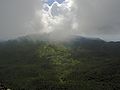
Another trail is the Tradewinds trail. This is possibly the longest trail in the park. It ends at El Toro Peak. From the summit of El Yunque, you can see the other peaks and the vast rainforest below. You can also see other parts of the island. The Quebrada Juan Diego river is just below El Yunque Peak. It has trails, waterfalls, and ponds to explore.
Gallery
-

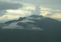
Morning mist in El Yunque rainforest by El Yunque peak.
-
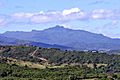
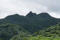
El Yunque massif with Pico El Yunque, Roca El Yunque and Mount Britton.
-
El Yunque view from Mount Britton Tower.
-
El Yunque from the north.
-
El Yunque from Yocahu Tower.
-
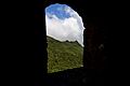
Los Picachos (left) and El Yunque (right) covered in fog.
-
El Yunque from the Northeast Ecological Corridor.
-


See also
 In Spanish: Pico El Yunque para niños
