Eldred Rock facts for kids

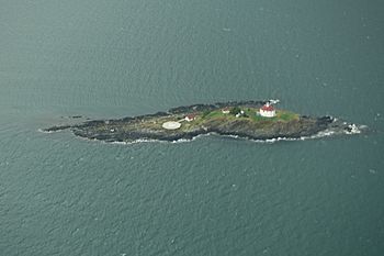
Eldred Rock and the lighthouse
|
|
| Geography | |
|---|---|
| Location | Juneau City and Borough, Alaska Haines Borough, Alaska |
| Coordinates | 58°58′18″N 135°13′15″W / 58.97167°N 135.22083°W |
| Archipelago | Alexander Archipelago |
| Adjacent bodies of water | Lynn Canal |
| Highest elevation | 0 ft (0 m) |
| Administration | |
|
United States
|
|
| State | Alaska |
| Borough | Juneau City and Borough |
| Borough | Haines Borough |
Eldred Rock (also called Nechraje) is a small island in Alaska, United States. It's located in an area called Lynn Canal. This island is part of both the Juneau and Haines regions.
Eldred Rock is about 2.7 miles (4.3 km) southeast of Kataguni Island. It's also about 55 miles (88 km) northwest of the city of Juneau.
The Famous Lighthouse
The most important thing on Eldred Rock is the Eldred Rock Light. This is a historic lighthouse that was built way back in 1905. For many years, people lived on the island to operate the lighthouse. Their job was to make sure the light was always working to guide ships safely.
In 1973, the United States Coast Guard made a big change. They updated the lighthouse so it could work all by itself. This means no one needed to live there anymore to keep it running. It became an "automated" lighthouse.
What Else is on the Island?
Besides the lighthouse, Eldred Rock also has a special landing spot for helicopters. This is called the Eldred Rock Coast Guard Heliport. It's used by the Coast Guard, probably to visit the lighthouse or for other important tasks in the area.
The name "Eldred Rock" was officially recorded by the United States Geological Survey between 1976 and 1981. It was added to a big list of geographic names on March 31, 1981.
 | Precious Adams |
 | Lauren Anderson |
 | Janet Collins |


