Ellston, Iowa facts for kids
Quick facts for kids
Ellston, Iowa
|
|
|---|---|
 |
|

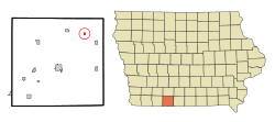
Location of Ellston, Iowa
|
|
| Country | |
| State | |
| County | Ringgold |
| Area | |
| • Total | 0.25 sq mi (0.64 km2) |
| • Land | 0.25 sq mi (0.64 km2) |
| • Water | 0.00 sq mi (0.00 km2) |
| Elevation | 1,230 ft (370 m) |
| Population
(2020)
|
|
| • Total | 19 |
| • Density | 76.31/sq mi (29.51/km2) |
| Time zone | UTC-6 (Central (CST)) |
| • Summer (DST) | UTC-5 (CDT) |
| ZIP code |
50074
|
| Area code(s) | 641 |
| FIPS code | 19-25005 |
| GNIS feature ID | 2394666 |
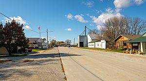
Ellston is a small city in Ringgold County, Iowa, United States. It is located in the midwestern part of the country. In 2020, the city had a population of 19 people.
Contents
History of Ellston
Ellston started as a small village called Wirt in 1881. Two business owners, Cochran & Le Fever, built a general store there. They hoped a railroad would soon come through the area.
Their business did not succeed and was sold six months later. However, in March 1882, the Humeston & Shenandoah Railroad did build a station in the village.
In 1895, the town's name was changed from Wirt to Ellston. This change was made to avoid confusion with another nearby town called Van Wert. People were getting their mail mixed up!
The western edge of Ellston is next to a road called P-64. This road was once part of the Dragoon Trace, an old trail used by soldiers.
Geography of Ellston
Ellston is located in Iowa. The United States Census Bureau reports that the city covers a total area of about 0.2 square miles (0.64 square kilometers). All of this area is land, with no water.
Population and People
This section tells us about the number of people living in Ellston and their characteristics.
How Many People Live Here?
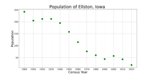
The population of Ellston has changed over the years. Here is a look at the population from different census reports:
| Historical population | |||
|---|---|---|---|
| Census | Pop. | %± | |
| 1900 | 242 | — | |
| 1910 | 205 | −15.3% | |
| 1920 | 212 | 3.4% | |
| 1930 | 212 | 0.0% | |
| 1940 | 195 | −8.0% | |
| 1950 | 158 | −19.0% | |
| 1960 | 115 | −27.2% | |
| 1970 | 76 | −33.9% | |
| 1980 | 60 | −21.1% | |
| 1990 | 44 | −26.7% | |
| 2000 | 57 | 29.5% | |
| 2010 | 43 | −24.6% | |
| 2020 | 19 | −55.8% | |
| U.S. Decennial Census | |||
Ellston in 2020
According to the 2020 census, 19 people lived in Ellston. These people made up 9 households and 5 families. The city had about 76 people per square mile.
There were 13 housing units in Ellston. All of the residents were White.
- About 22% of the households had children under 18 living with them.
- About 33% of households were married couples.
- About 67% of households had a female head with no spouse.
The average age of people in Ellston was 61.5 years old. About 5% of residents were under 20 years old. Most residents were 45 years or older. More females lived in Ellston than males.
Education in Ellston
Students in Ellston attend public schools operated by the Mount Ayr Community School District.
Notable People from Ellston
- Harley A. Wilhelm was a famous chemist. He was born on a farm near Ellston. He helped create a special way to purify uranium. This work was important for making the atomic bomb during the Manhattan Project.
See also
 In Spanish: Ellston (Iowa) para niños
 | Calvin Brent |
 | Walter T. Bailey |
 | Martha Cassell Thompson |
 | Alberta Jeannette Cassell |


