Empire, Louisiana facts for kids
Quick facts for kids
Empire, Louisiana
|
|
|---|---|
|
Census-designated place
|
|
| Country | United States |
| State | Louisiana |
| Parish | Plaquemines |
| Area | |
| • Total | 7.62 sq mi (19.72 km2) |
| • Land | 5.22 sq mi (13.51 km2) |
| • Water | 2.40 sq mi (6.21 km2) |
| Elevation | 3 ft (0.9 m) |
| Population
(2020)
|
|
| • Total | 905 |
| • Density | 173.47/sq mi (66.98/km2) |
| Time zone | UTC-6 (CST) |
| • Summer (DST) | UTC-5 (CDT) |
| ZIP Code |
70050
|
| Area code(s) | 504 |
| FIPS code | 22-23725 |
Empire is a small community in Plaquemines Parish, Louisiana, United States. It is known as a census-designated place (CDP). This means it's an area that the U.S. Census Bureau defines for gathering population data. In 2020, about 905 people lived in Empire.
Contents
A Hub for Seafood
Empire is a very important place for seafood! Along with a nearby town called Venice, it's one of the biggest seafood ports in the United States. This is measured by how much seafood is caught and how much it's worth.
- Many fishing boats, around 2,000 of them, call Empire their home port.
- Fishermen here catch all sorts of seafood. This includes delicious oysters, shrimp, and different kinds of fish.
However, the seafood industry here has faced challenges. During the 2010 BP oil spill, fishing stopped completely. It took a whole year for oyster fishing to start again. There's also a plan called the Coast 2050 plan. It suggests building a large freshwater diversion near Empire. This could change the saltiness of the water in the nearby marshes. Such a change might affect the lives of fishermen and local businesses.
Hurricane Katrina's Impact

On August 28, 2005, a very strong storm called Hurricane Katrina moved towards the coast. It brought strong winds to states like Florida, Alabama, Mississippi, and Louisiana. Early on August 29, 2005, Katrina officially hit land. It made landfall just a few miles southeast of Empire, near Buras-Triumph.
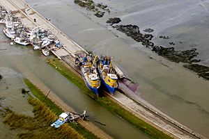
The eye of the storm, which is the calm center, passed right over Empire that morning. The entire area was flooded. Many shrimp and oyster boats were pushed onto roads and levees. Dozens of boats broke free from their docks. They ended up near the Empire High Rise Bridge. This meant that all traffic in and out of southern Plaquemines Parish had to use a different bridge. Many local businesses, like Tom's Place Oyster Bar and The Delta Marina, were completely destroyed by the storm.
Geography of Empire
Empire is located at 29°23′55″N 89°36′31″W / 29.39861°N 89.60861°W. It sits at an elevation of about 3 feet (1 meter) above sea level.
The total area of Empire is about 7.6 square miles (19.7 square kilometers). Most of this area, about 5.2 square miles (13.5 square kilometers), is land. The rest, about 2.4 square miles (6.2 square kilometers), is water.
Education in Empire
Students in Empire attend schools that are part of the Plaquemines Parish School Board school district.
- South Plaquemines High School is located right in Empire.
- For higher education, Plaquemines Parish is served by Nunez Community College.
Population Changes
The number of people living in Empire has changed over the years:
- In 2000, the population was 2,211.
- By 2010, it had decreased to 993.
- In 2020, the population was 905.
This shows a decrease in population, especially after events like Hurricane Katrina.
See also
 In Spanish: Empire (Luisiana) para niños
 | James B. Knighten |
 | Azellia White |
 | Willa Brown |


