Ensenada, Rincón, Puerto Rico facts for kids
Quick facts for kids
Ensenada
|
|
|---|---|
|
Barrio
|
|

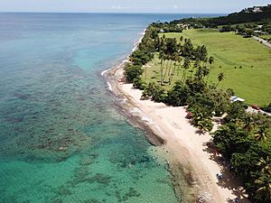
Tres Palmas Marine Reserve in Ensenada
|
|

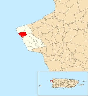
Location of Ensenada within the municipality of Rincón shown in red
|
|
| Commonwealth | |
| Municipality | |
| Area | |
| • Total | 1.34 sq mi (3.5 km2) |
| • Land | 1.09 sq mi (2.8 km2) |
| • Water | 0.25 sq mi (0.6 km2) |
| Elevation | 72 ft (22 m) |
| Population
(2010)
|
|
| • Total | 1,328 |
| • Density | 1,218.3/sq mi (470.4/km2) |
| Source: 2010 Census | |
| Time zone | UTC−4 (AST) |
Ensenada is a small area, like a neighborhood, located in the municipality of Rincón, Puerto Rico. It's on the beautiful western coast of the island. In 2010, about 1,328 people lived there. Ensenada is known for its lovely beaches and is divided into many smaller sections. One famous spot is Steps Beach, which is popular with surfers and is part of the Tres Palmas Reserve. This reserve is an important natural area found between Ensenada and Puntas in Rincón.
A Look Back in Time
After the Spanish–American War, Spain gave Puerto Rico to the United States in 1898. This happened because of a special agreement called the Treaty of Paris of 1898. Puerto Rico then became an unincorporated territory of the United States. This means it's a part of the U.S. but doesn't have all the same rights as a state.
In 1899, the United States Department of War took a count of all the people in Puerto Rico. This count, called a census, found that 674 people lived in the Ensenada area. The population has grown quite a bit since then!
| Historical population | |||
|---|---|---|---|
| Census | Pop. | %± | |
| 1900 | 674 | — | |
| 1910 | 758 | 12.5% | |
| 1920 | 876 | 15.6% | |
| 1930 | 721 | −17.7% | |
| 1940 | 951 | 31.9% | |
| 1950 | 658 | −30.8% | |
| 1980 | 769 | — | |
| 1990 | 763 | −0.8% | |
| 2000 | 1,301 | 70.5% | |
| 2010 | 1,328 | 2.1% | |
| U.S. Decennial Census 1899 (shown as 1900) 1910-1930 1930-1950 1980-2000 2010 |
|||
What's Special Here?
One of the most important places in Ensenada is the Tres Palmas Reserve. This special area was created by local people, including fishermen, surfers, and other community members. They wanted to protect the beautiful coast. The reserve is located along the coast of both Ensenada and Puntas neighborhoods. It's a great place for nature lovers and those who enjoy the ocean.
Neighborhoods
In Puerto Rico, larger areas called barrios are often divided into even smaller local parts. These smaller parts are called sectores (which means sectors in English). Think of them like different neighborhoods or sections within a bigger area.
The types of sectores can be different. Some are simply called sector, while others might be named urbanización (like a housing development), reparto (a subdivision), barriada (a settlement), or residencial (a residential area).
Here are some of the neighborhoods you can find in Ensenada:
- Calle Gabino Tirado
- Calle Sol
- Camino José Pérez
- Carretera 115
- Carretera 413
- Colinas de Ensenada
- Condominio Arenas del Mar
- Condominio Bahía del Mar
- Condominio Chalet del Mar
- Condominio Costa Ensenada
- Condominio Ensenada del Mar
- Condominio Rincón By The Seas
- Condominio Rincón Ocean View
- Condominio Rincón Wave View
- Condominio Solymar
- Extensión Jardines de Rincón
- Parada Muñoz
- Sección Cambijas
- Sector Ensenada
- Sector Ismael Sánchez
- Sector Quintana
- Urbanización Jardines de Rincón
- Urbanización Vista Azul
See Also
 In Spanish: Ensenada (Rincón) para niños
- List of communities in Puerto Rico
- List of barrios and sectors of Rincón, Puerto Rico
 | George Robert Carruthers |
 | Patricia Bath |
 | Jan Ernst Matzeliger |
 | Alexander Miles |


