
Entrepierres facts for kids
Quick facts for kids
Entrepierres
|
||
|---|---|---|

Bridge of Queen Jeanne
|
||
|
||

Entrepierres
Location in France

Entrepierres
Location in Provence-Alpes-Côte d'Azur
|
||
| Country | France | |
| Region | Provence-Alpes-Côte d'Azur | |
| Department | Alpes-de-Haute-Provence | |
| Arrondissement | Forcalquier | |
| Canton | Sisteron | |
| Intercommunality | Sisteron | |
| Area
1
|
47.79 km2 (18.45 sq mi) | |
| Population
(Jan. 2019)
|
372 | |
| • Density | 7.784/km2 (20.161/sq mi) | |
| Time zone | UTC+01:00 (CET) | |
| • Summer (DST) | UTC+02:00 (CEST) | |
| INSEE/Postal code |
04075 /04200
|
|
| Elevation | 455–1,444 m (1,493–4,738 ft) (avg. 600 m or 2,000 ft) |
|
| 1 French Land Register data, which excludes lakes, ponds, glaciers > 1 km2 (0.386 sq mi or 247 acres) and river estuaries. | ||

Entrepierres is a small commune located in the Alpes-de-Haute-Provence department in southeastern France. A commune is like a local town or village area. It is the smallest type of administrative division in France.
Contents
What is Entrepierres?
Entrepierres is a quiet place in the French countryside. It is known for its natural beauty. The name "Entrepierres" means "between stones." This name likely refers to its location among rocky landscapes.
Where is Entrepierres Located?
Entrepierres is found in the Provence-Alpes-Côte d'Azur region of France. This region is famous for its sunny weather and beautiful scenery. The commune is part of the Alpes-de-Haute-Provence department. This area is known for its mountains and valleys.
Nearby Towns and Areas
The commune is close to the town of Sisteron. Sisteron is a larger town with historical importance. Entrepierres is also part of the Forcalquier arrondissement. An arrondissement is a type of administrative district.
How Many People Live in Entrepierres?
As of January 2019, about 372 people live in Entrepierres. This makes it a very small community. Small communes often have a close-knit feel. Everyone knows their neighbors.
What is the Area Like?
Entrepierres covers an area of about 47.79 square kilometers. This is roughly 18.45 square miles. The land here varies quite a bit.
Elevation and Landscape
The lowest point in Entrepierres is 455 meters above sea level. The highest point reaches 1444 meters. This means the area has both lower valleys and higher hills. The average elevation is around 600 meters. This varied landscape offers many outdoor activities.
Who Manages Entrepierres?
Like all communes in France, Entrepierres has a local government. This government is led by a mayor. The mayor helps manage daily life in the commune. They work with a council to make decisions for the community.
Local Administration
The commune is part of the Sisteron intercommunality. This means it works with nearby communes. They share resources and services. This helps small towns manage things like waste collection or public transport.
Images for kids
-
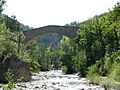
The historic Bridge of Queen Jeanne in Entrepierres.
See also
 In Spanish: Entrepierres para niños
