Eresma River facts for kids
Quick facts for kids River Eresma |
|
|---|---|

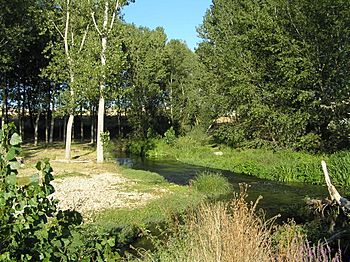
The Eresma River as it passes through Los Redondillos (Los Huertos, Segovia)
|
|
| Country | Spain |
| Region | Castile and León |
| Physical characteristics | |
| River mouth | Adaja River 41°26′38″N 4°45′15″W / 41.44378°N 4.75404°W |
| Length | 134 km |
| Basin features | |
| Progression | Adaja→ Douro→ Atlantic Ocean |
The Eresma is a river located in central Spain. It flows through the region of Castile and León, passing through the provinces of Segovia and Valladolid. The river is about 134 kilometers (83 miles) long. Its basin, which is the area of land that drains into the river, covers about 2,940 square kilometers (1,135 square miles).
Contents
What's in a Name? The Eresma River's Story
The name of the Eresma River comes from an ancient language called Iberian. The original word was "Iri-sama." This means "that which surrounds the big city." You might think this "big city" is Segovia, but it's actually the town of Coca. Coca is located about 50 kilometers (31 miles) away from Segovia.
Where Does the Eresma River Flow?
Starting Point and Tributaries
The Eresma River begins in the Valsaín valley. This valley is part of the Sierra de Guadarrama mountain range. Several small streams come together here to form the river. Many of these streams flow down from mountains like Peñalara, Siete Picos, and Montón de Trigo. The most important rivers that join the Eresma are the Moros and the Voltoya. Both of these flow towards the north.
Journey Through Cities and Towns
After starting its journey, the Eresma River flows past San Ildefonso and Palazuelos. It then reaches the city of Segovia. Here, the river forms a tight curve, almost wrapping around the city. This curve is called a meander.
From Segovia, the Eresma River continues its path northwest. It passes by towns such as Hontanares, Los Huertos, Bernardos, Navas de Oro, Coca, and Villeguillo. The river then enters the province of Valladolid. In Valladolid, it flows near Olmedo, Pedrajas, Alcazarén, and Hornillos. Finally, the Eresma River flows into the Adaja from the right side, near the town of Matapozuelos.
How the River's Water Levels Change
The Eresma River has what is called a "pluvio-nival regime." This means its water levels change based on both rain and melting snow. The river usually has a lot of water during the autumn and winter. This is because of the rain that falls during these seasons. In the spring, when the snow on the mountains melts, the river can have a quick and strong flow of water.
See also
In Spanish: Eresma para niños
 | Shirley Ann Jackson |
 | Garett Morgan |
 | J. Ernest Wilkins Jr. |
 | Elijah McCoy |

