
Espigüete facts for kids
Quick facts for kids Espigüete |
|
|---|---|
 |
|
| Highest point | |
| Elevation | 2,450 m (8,040 ft) |
| Prominence | 474 m (1,555 ft) |
| Geography | |

Location in the Province of Palencia.
|
|
| Location | |
| Country | |
| Geology | |
| Mountain type | Limestone |
| Climbing | |
| First ascent | 1854 |
| Normal route | South, from Cardaño de Abajo |
Espigüete Peak (called Pico Espigüete in Spanish) is a tall mountain in Spain. It stands 2,450 meters (about 8,038 feet) high! Even though it's not the very tallest mountain in the Cantabrian Mountains, it's one of the most famous and easily recognized peaks in the Montaña Palentina area. You can find it near the town of Velilla del Río Carrión.
Contents
Where is Espigüete?
Espigüete is located in northern Spain, in a beautiful area called the Montaña Palentina Natural Park. It's right next to a small town called Cardaño de Abajo. The mountain is about 26 kilometers (16 miles) from Guardo and 126 kilometers (78 miles) from Palencia. Part of its western side also touches the town of Valverde de la Sierra in the Province of León.
What Makes Espigüete Special?
Shape and Appearance
Espigüete is shaped like a pyramid and is mostly made of limestone. You can spot it from far away because it stands alone, not surrounded by other tall peaks. The southern side of the mountain has gentle slopes, while the northern side has steep, straight walls.
The mountain's look changes with the seasons and how the light hits it. In winter, it's usually covered in snow, making it look even more impressive.
Natural Park Home
Espigüete is part of the Fuentes Carrionas y Fuente Cobre-Montaña Palentina Natural Park. This park was officially created on June 27, 2000. It's a protected area known for its high peaks, like Curavacas (which is 2,528 meters tall), and deep valleys. The difference in height between the peaks and the valley bottoms can be more than 1,000 meters!
Hidden Caves and Rivers
Even though Espigüete looks solid from the outside, it has many hidden spaces inside. There are huge canyons with underground rivers and lakes. You can also find deep pits and caves. This makes Espigüete a fascinating place for speleologists, who are people who explore caves.
Mountain Plants
The plants on Espigüete are a mix of those found in central and northern Europe and those from the Mediterranean region. Because it's a high mountain, there isn't a lot of thick plant life. You'll mostly see lichen and small plants that are tough enough to grow in the mountains.
One special plant found here is a type of sempervivum. This particular variety only grows on Espigüete! It was discovered in 1935 by a famous botanist named Paul Leon Giuseppi, and it was named Sempervivum Giuseppii in his honor.
Who First Climbed Espigüete?
The first person recorded to climb Espigüete was a geologist and naturalist named Casiano de Prado. He reached the top in 1854. Later, in 1892, Aymar de Saint-Saud also climbed it during one of his trips to the Picos de Europa mountains.
Images for kids
-
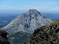
Espigüete seen from Curavacas peak.
-
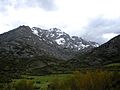
The northeast face of Espigüete, from Cardaño de Arriba.
-
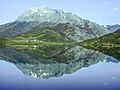
Southeast view of Espigüete reflected in the Camporredondo Reservoir.
-
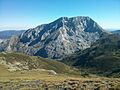
View of Espigüete from La Cerezuela range.


See also
 In Spanish: Espigüete para niños
