Evansdale, Iowa facts for kids
Quick facts for kids
Evansdale
|
|
|---|---|
| Nickname(s):
Edale
|
|

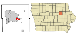
Location of Evansdale, Iowa
|
|
| Country | |
| State | |
| County | Black Hawk |
| Incorporated | November 13, 1947 |
| Government | |
| Area | |
| • Total | 4.06 sq mi (10.52 km2) |
| • Land | 4.00 sq mi (10.35 km2) |
| • Water | 0.07 sq mi (0.17 km2) |
| Elevation | 840 ft (256 m) |
| Population
(2020)
|
|
| • Total | 4,561 |
| • Density | 1,141.39/sq mi (440.65/km2) |
| Time zone | UTC-6 (Central (CST)) |
| • Summer (DST) | UTC-5 (CDT) |
| ZIP code |
50707
|
| Area code(s) | 319 |
| FIPS code | 19-25995 |
| GNIS feature ID | 0456412 |
Evansdale is a city located in Black Hawk County, Iowa, in the United States. In 2020, about 4,561 people lived there. This was a small increase from the 4,526 people counted in 2000. Evansdale is part of the larger Waterloo and Cedar Falls area.
Contents
Geography of Evansdale
Evansdale is located at 42.467837 degrees north and -92.282105 degrees west. This helps pinpoint its exact spot on a map.
The city covers a total area of about 4.12 square miles (10.67 square kilometers). Most of this area, about 4.05 square miles (10.49 square kilometers), is land. The rest, about 0.07 square miles (0.18 square kilometers), is water.
Evansdale is a suburb that borders the city of Waterloo.
History of Evansdale
How Evansdale Began
Evansdale started in 1947. People living in the Home Acres and River Forest areas, which were next to Waterloo, had a problem with water drainage. They formed a group called the Home Acres Improvement Association.
In August 1947, this group asked to officially become a town. They presented their request to Judge William T. Evans. The town was named "Evansdale" after him. A vote was held, and 205 people voted yes, while 106 voted no. So, the town was officially formed.
Early Development and Growth
The area that became Evansdale grew from several different sections. Around the early 1900s, William T. Evans owned a farm. Julia B. Richards also owned a farm nearby. A school called County School #1 was located on Richards' property. This area became known as Evans Crossing.
Other large farmers in the area included Mary C. Crumrine, Jacob Griffith, and Samuel R. White.
The Elk Run Hotel and Home Acres
Another part of Evansdale came from land owned by C.C. Wolf. In the early 1900s, Wolf built the Elk Run Hotel. It was a summer resort with a large ballroom and dining room. People from northeast Iowa would visit the resort, which was located by the Cedar River. Commuter trains brought visitors there on weekends.
Wolf tried to sell land lots in the area, but his hotel business didn't do well. In 1928, William Fox started the Home Acres Land Association. This group developed the land that Wolf used to own, along with other areas. The Home Acres Land Association first had its office in the Elk Run Hotel.
Casebeer Heights and Later Growth
Before Fox developed Home Acres, another section called Casebeer Heights was created. Lore Alford, a lawyer from Waterloo, owned this land. He sold it to Jack Casebeer, a restaurant owner. Casebeer developed this area as another summer resort.
More parts of Evansdale were developed before 1941. However, a building boom after World War II caused problems that led to the city's official start.
First City Leaders
On November 1, 1947, 110 voters chose William Wiltfang as the first mayor. The first city council meeting happened on November 24, 1947. It was held in an old chicken house owned by one of the council members, Mr. Boelman.
Since then, Evansdale has grown steadily. The city needed new sewers and water lines to keep up with its growth. In 1969, an Urban Renewal program helped the city get a fresh start. This program brought new housing and renovations, giving Evansdale a new look.
Population and People
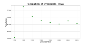
| Historical population | |||
|---|---|---|---|
| Census | Pop. | %± | |
| 1950 | 3,571 | — | |
| 1960 | 5,738 | 60.7% | |
| 1970 | 5,038 | −12.2% | |
| 1980 | 4,798 | −4.8% | |
| 1990 | 4,638 | −3.3% | |
| 2000 | 4,526 | −2.4% | |
| 2010 | 4,751 | 5.0% | |
| 2020 | 4,561 | −4.0% | |
| U.S. Decennial Census | |||
2020 Population Count
The census is a count of all the people living in a place. In 2020, Evansdale had 4,561 people. There were 2,037 households, which are groups of people living together.
Most people in Evansdale were White (89.1%). About 2.8% were Black or African American, and 0.6% were Asian. People of Hispanic or Latino background made up 2.9% of the population.
The average age in Evansdale was 42.5 years. About 24.1% of residents were under 20 years old. About 20.4% were 65 years old or older. The population was almost evenly split between males (49.2%) and females (50.8%).
2010 Population Count
In the 2010 census, Evansdale had 4,751 people. There were 1,987 households. The population density was about 1,173 people per square mile (453 people per square kilometer).
Most people were White (94.8%). About 1.7% were African American. Hispanic or Latino people made up 1.7% of the population.
About 31.2% of households had children under 18 living with them. The average household had 2.39 people. The average family had 2.87 people.
The median age in 2010 was 38 years. About 23.3% of residents were under 18. About 13.9% were 65 years old or older. The city was 48.9% male and 51.1% female.
Parks and Recreation
Evansdale is home to a starting point for the Cedar Valley Nature Trail. This trail is a great place for walking, running, and biking.
Education in Evansdale
Children in Evansdale attend schools within the Waterloo Community School District.
The schools located in Evansdale are:
- Bunger Middle School
- Poyner Elementary School
See also
 In Spanish: Evansdale (Iowa) para niños
 | Jessica Watkins |
 | Robert Henry Lawrence Jr. |
 | Mae Jemison |
 | Sian Proctor |
 | Guion Bluford |


