Evarts, Kentucky facts for kids
Quick facts for kids
Evarts, Kentucky
|
|
|---|---|

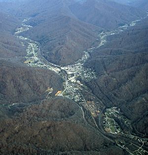
Evarts from the air
|
|

Location of Evarts in Harlan County, Kentucky.
|
|
| Country | United States |
| State | Kentucky |
| County | Harlan |
| Incorporated | 1921 |
| Government | |
| • Type | Mayor-Council |
| Area | |
| • Total | 0.40 sq mi (1.03 km2) |
| • Land | 0.38 sq mi (0.99 km2) |
| • Water | 0.02 sq mi (0.04 km2) |
| Elevation | 1,575 ft (480 m) |
| Population
(2020)
|
|
| • Total | 859 |
| • Density | 2,248.69/sq mi (867.11/km2) |
| Time zone | UTC-5 (Eastern (EST)) |
| • Summer (DST) | UTC-4 (EDT) |
| ZIP code |
40828
|
| Area code(s) | 606 |
| FIPS code | 21-25606 |
| GNIS feature ID | 0491839 |
Evarts is a small city in Harlan County, Kentucky, in the United States. It is known as a "home rule-class city," which means it has the power to manage its own local affairs. The city's post office first opened on February 9, 1855. It was named after one of the early families who settled in the area. Evarts was officially recognized as a city by the state assembly in 1921. According to the 2020 census, about 859 people live in Evarts.
Contents
Exploring Evarts: Location and Landscape
Evarts is located in the middle of Harlan County. It sits in the valley of the Clover Fork of the Cumberland River. Another stream, Yocum Creek, joins the Clover Fork from the southeast right in Evarts.
Roads and Travel
Kentucky Route 38, also known as Main Street, follows the Clover Fork. If you travel northeast on this road, you'll go about 21 miles (34 km) to the Virginia border. If you go southwest, you'll reach Harlan, the county seat, which is about 8 miles (13 km) away. Kentucky Route 215 heads southeast from Evarts, following the Yocum Creek valley. This route passes through towns like Kenvir and Dizney.
Size of the City
The United States Census Bureau reports that Evarts covers a total area of about 0.40 square miles (1.04 square kilometers). A small part of this area, about 0.02 square miles (0.04 square kilometers), is water.
People of Evarts: Population Facts
The number of people living in Evarts has changed over the years. Here's a quick look at the population from different census reports:
| Historical population | |||
|---|---|---|---|
| Census | Pop. | %± | |
| 1920 | 502 | — | |
| 1930 | 1,438 | 186.5% | |
| 1940 | 1,642 | 14.2% | |
| 1950 | 1,937 | 18.0% | |
| 1960 | 1,473 | −24.0% | |
| 1970 | 1,182 | −19.8% | |
| 1980 | 1,234 | 4.4% | |
| 1990 | 1,063 | −13.9% | |
| 2000 | 1,101 | 3.6% | |
| 2010 | 962 | −12.6% | |
| 2020 | 859 | −10.7% | |
| U.S. Decennial Census | |||

Population Details (2000 Census)
In the year 2000, there were 1,101 people living in Evarts. These people lived in 428 households, and 299 of these were families. The city had about 1,828 people per square mile.
- About 31% of households had children under 18 living with them.
- More than half (50.7%) of households were married couples.
- About 15.9% of households were led by a female with no husband present.
- Around 13.6% of households had someone living alone who was 65 years or older.
The average age of people in Evarts in 2000 was 36 years old. About 28.4% of the population was under 18, and 13.6% was 65 or older.
Education in Evarts
The schools in Evarts are part of the Harlan County Public Schools district.
- Elementary Schools: Students attend Evarts Elementary School or Black Mountain Elementary School.
- High School: Older students go to Harlan County High School.
Evarts also has a lending library. It is a branch of the Harlan County Public Library, where you can borrow books and other materials.
See also
 In Spanish: Evarts (Kentucky) para niños
 | George Robert Carruthers |
 | Patricia Bath |
 | Jan Ernst Matzeliger |
 | Alexander Miles |

