Exline, Iowa facts for kids
Quick facts for kids
Exline, Iowa
|
|
|---|---|
|
City
|
|

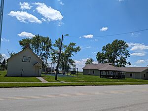
"The Old School" (left) next to a public park in Exline
|
|

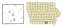
Location of Exline, Iowa
|
|
| Country | USA |
| State | |
| County | Appanoose |
| Incorporated | June 20, 1904 |
| Area | |
| • Total | 0.99 sq mi (2.57 km2) |
| • Land | 0.99 sq mi (2.57 km2) |
| • Water | 0.00 sq mi (0.00 km2) |
| Elevation | 1,014 ft (309 m) |
| Population
(2020)
|
|
| • Total | 160 |
| • Density | 161.13/sq mi (62.19/km2) |
| Time zone | UTC-6 (Central (CST)) |
| • Summer (DST) | UTC-5 (CDT) |
| ZIP code |
52555
|
| Area code(s) | 641 |
| FIPS code | 19-26310 |
| GNIS feature ID | 2394721 |
Exline is a small city located in Appanoose County, Iowa, United States. In the 2020 census, 160 people lived there. This was a bit less than the 191 people who lived there in 2000. Exline officially became a city on June 20, 1904.
Contents
History of Exline
Exline was first mapped out in 1873 by J.J. Hall. It was named after David Exline, who settled there. David Exline started a successful store that sold many different goods. At first, the town had other names like Caldwell City or Bob Town. But when a post office opened in 1877, they needed an official name, so they chose Exline.
Coal Mining in Exline
Exline grew a lot because of the coal mining industry. Many people came to work in the mines. In 1899, a group called the United Mine Workers Local 812 was formed in Exline. By 1907, this group had 200 members. Even in 1912, it still had 180 members.
In 1906, several coal companies operated around Exline. The Exline Coal Company had two mine shafts west of town. The Iowa Block Coal Company also had a mine in Exline. The White Oak Coal Company had a mine north of town, and the Royal Mine was to the east, though it was not active then.
Geography of Exline
According to the United States Census Bureau, the city of Exline covers a total area of about 0.99 square miles (2.57 square kilometers). All of this area is land.
Exline's Unique Rocks
Geologists have named a special rock group after the town called the Exline cyclothem. This rock group stretches from Iowa all the way into Illinois. It includes a type of rock called Exline limestone. This limestone was named because it was found exposed on a creek bank about 1.5 miles south of Exline.
Exline's Population
| Historical population | |||
|---|---|---|---|
| Census | Pop. | %± | |
| 1880 | 34 | — | |
| 1910 | 660 | — | |
| 1920 | 755 | 14.4% | |
| 1930 | 437 | −42.1% | |
| 1940 | 481 | 10.1% | |
| 1950 | 342 | −28.9% | |
| 1960 | 223 | −34.8% | |
| 1970 | 224 | 0.4% | |
| 1980 | 217 | −3.1% | |
| 1990 | 187 | −13.8% | |
| 2000 | 191 | 2.1% | |
| 2010 | 160 | −16.2% | |
| 2020 | 160 | 0.0% | |
| U.S. Decennial Census | |||
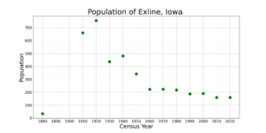
The population of Exline has changed a lot over the years. In 1880, only 34 people lived there. The population grew a lot during the coal boom, reaching 755 people in 1920. After that, the population slowly decreased. By 2010 and 2020, the population was 160 people.
Life in Exline in 2020
In 2020, there were 160 people living in Exline. These people lived in 75 households. Most of the people living in Exline were White (96.9%). A small number of people (2.5%) were from two or more races.
About one-third of the households (33.3%) had children under 18 living with them. Many households (54.7%) were married couples living together. The average age of people in Exline was 50 years old. About 25.6% of the residents were under 20 years old.
Education in Exline
The Centerville Community School District is in charge of the public schools in the Exline area. This means students living in Exline attend schools within this district.
See also
 In Spanish: Exline (Iowa) para niños
 | Dorothy Vaughan |
 | Charles Henry Turner |
 | Hildrus Poindexter |
 | Henry Cecil McBay |


