Fairton, New Jersey facts for kids
Quick facts for kids
Fairton, New Jersey
|
|
|---|---|

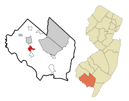
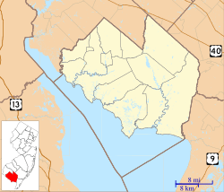
Map of Fairton highlighted within Cumberland County. Right: Location of Cumberland County in New Jersey.
|
|
| Country | |
| State | |
| County | Cumberland |
| Township | Fairfield |
| Area | |
| • Total | 2.99 sq mi (7.73 km2) |
| • Land | 2.87 sq mi (7.43 km2) |
| • Water | 0.12 sq mi (0.30 km2) 4.29% |
| Elevation | 26 ft (8 m) |
| Population
(2020)
|
|
| • Total | 1,060 |
| • Density | 369.47/sq mi (142.65/km2) |
| Time zone | UTC−05:00 (Eastern (EST)) |
| • Summer (DST) | UTC−04:00 (Eastern (EDT)) |
| ZIP Code |
08320
|
| Area code(s) | 856 |
| FIPS code | 34-22530 |
| GNIS feature ID | 02389066 |
Fairton is a small community in New Jersey, United States. It's located within Fairfield Township in Cumberland County. Fairton is also known as a census-designated place (CDP), which means it's an area that the government counts for population statistics. It's part of a larger area that includes the cities of Vineland, Millville, and Bridgeton. In 2020, about 1,060 people lived in Fairton.
Contents
History of Fairton
Before European settlers arrived, the land where Fairton now stands was home to the Lenape and Nanticoke tribes. These Native American groups spoke languages from the Algonquian family. Over time, settlers from Europe moved into their territory.
Early Industries and Growth
The first important business in Fairfield Township was a mill. It was built by an English settler named Samuel Fithian before 1702. This mill helped process grains for the community. Later, around the 1810s, Fairton became known for its pork and beef businesses.
The town also had a busy public wharf, which was like a dock for boats. From this wharf, people shipped vegetables, fish, and lumber to bigger cities. Fairton was also good at building boats. Between 1850 and 1897, its shipyards built three sloops, which are a type of sailboat.
Native American Heritage
In 1978, some of the Native American people from Cumberland County formed the Nanticoke Lenni-Lenape Tribal Nation. Their cultural center is in Fairton, and their main office is in Bridgeton. The tribe stated that in 2016, they had about 3,000 members. These members can show they are related to the original families of the tribe. The tribe has been working to get official recognition from the United States government.
Geography of Fairton
Fairton covers a total area of about 2.99 square miles (7.73 square kilometers). Most of this area, about 2.86 square miles (7.43 square kilometers), is land. The rest, about 0.128 square miles (0.30 square kilometers), is water.
Population and People
Fairton's population has changed over the years. In 2010, there were 1,264 people living there. By 2020, the population was 1,060 people.
Fairton's Community in 2010
According to the 2010 census, there were 529 households in Fairton. A household is a group of people living together in one home. About 23.4% of these households had children under 18. Many households, 45.4%, were married couples.
The average age of people in Fairton in 2010 was about 43.7 years old. About 20.1% of the population was under 18 years old.
Notable People from Fairton
Some interesting people have connections to Fairton:
- Nathaniel Clark Burt (1825–1874) was a Presbyterian clergyman, which means he was a religious leader.
- John T. Nixon (1820–1889) was a politician who represented New Jersey in the United States House of Representatives from 1859 to 1863.
See also
 In Spanish: Fairton para niños
 | John T. Biggers |
 | Thomas Blackshear |
 | Mark Bradford |
 | Beverly Buchanan |


