Faverolles, Aisne facts for kids
Quick facts for kids
Faverolles
|
|
|---|---|

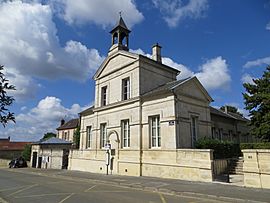
The town hall of Faverolles
|
|
| Country | France |
| Region | Hauts-de-France |
| Department | Aisne |
| Arrondissement | Soissons |
| Canton | Villers-Cotterêts |
| Intercommunality | Villers-Cotterêts–Forêt de Retz |
| Area
1
|
13.79 km2 (5.32 sq mi) |
| Population
(2008)
|
346 |
| • Density | 25.09/km2 (64.98/sq mi) |
| Time zone | UTC+01:00 (CET) |
| • Summer (DST) | UTC+02:00 (CEST) |
| INSEE/Postal code |
02302 /02600
|
| Elevation | 67–177 m (220–581 ft) (avg. 140 m or 460 ft) |
| 1 French Land Register data, which excludes lakes, ponds, glaciers > 1 km2 (0.386 sq mi or 247 acres) and river estuaries. | |
Faverolles is a small town in northern France. It is known as a "commune," which is like a local government area or a small community. Faverolles is located in the Aisne department, which is part of the Picardie region. This area is in the northern part of France, known for its green landscapes and history.
Contents
About Faverolles
Faverolles is a quiet place with a small number of people living there. It is a great example of a typical French village. The town is managed by local leaders who work to make it a good place to live.
Where is Faverolles Located?
Faverolles is found in the Aisne department. This department is in the Picardie region of France. It is located north of Paris, the capital city. The town's exact position is given by its coordinates: 49.22 degrees north and 3.1764 degrees east. These numbers help pinpoint its spot on a map.
Nearby Areas
The town is part of the Soissons arrondissement and the Villers-Cotterêts canton. These are ways that France organizes its local areas. Faverolles also works with nearby towns in a group called Villers-Cotterêts–Forêt de Retz. This helps them share services and work together.
How Many People Live in Faverolles?
In 2008, about 346 people lived in Faverolles. This makes it a very small community. The number of people living in a commune can change over time. Small towns like Faverolles often have a close-knit community feel.
The Town's Geography
Faverolles covers an area of about 13.79 square kilometers (about 5.3 square miles). The land in Faverolles has different heights. The lowest point is 67 meters (about 220 feet) above sea level. The highest point reaches 177 meters (about 581 feet). The average height of the town is 140 meters (about 459 feet). This means it has some hills and valleys.
Who Leads Faverolles?
Like all communes in France, Faverolles has a mayor. The mayor is the main leader of the town. From 2008 to 2014, Alexandre Potel was the mayor of Faverolles. The mayor helps manage the town's services, like roads and schools. They also represent the town in bigger government meetings.
See also
 In Spanish: Faverolles (Aisne) para niños


