
Fish River (Maine) facts for kids
Quick facts for kids Fish River |
|
|---|---|

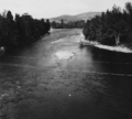
Fish River in 1940 near its confluence with the Saint John River at Fort Kent, Maine
|
|


|
|
| Country | United States |
| Physical characteristics | |
| Main source | Maine |
| River mouth | Saint John River 500 feet (150 m) 47°15′14″N 68°35′42″W / 47.2540°N 68.5950°W |
The Fish River is a river about 70 miles (113 km) long in northern Maine, United States. It flows into the Saint John River, which then empties into the Bay of Fundy in New Brunswick, Canada. The Bay of Fundy is part of the Atlantic Ocean.
The Fish River starts where Fox Brook and Carr Pond Stream meet. From there, it flows north to Fish River Lake, then east to Portage Lake. After that, it continues north through St. Froid Lake and Eagle Lake. Finally, it reaches the Saint John River near Fort Kent. A road called Maine State Route 11 runs alongside this part of the river.
Fish River Lake
| Fish River Lake | |
|---|---|
| Lua error in Module:Location_map at line 420: attempt to index field 'wikibase' (a nil value). | |
| Location | Aroostook County, Maine |
| Max. length | 4 mi (6.4 km) |
| Surface area | 2,568 acres (1,039 ha) |
| Water volume | 42,043 acre⋅ft (51,859,000 m3) |
| Surface elevation | 716 ft (218 m) |
Fish River Lake is located in Maine. The Fish River flows into the south end of this lake. Other smaller streams, like Smith Brook and Chase Brook, also flow into the west side of the lake. The Fish River then leaves the north end of Fish River Lake, flowing into Round Pond, and continues about 12 miles (19 km) to Portage Lake.
Portage Lake
| Portage Lake | |
|---|---|
| Lua error in Module:Location_map at line 420: attempt to index field 'wikibase' (a nil value). | |
| Location | Aroostook County |
| Max. length | 4.3 mi (6.9 km) |
| Surface area | 2,258 acres (914 ha) |
| Water volume | 18,971 acre⋅ft (23,400,000 m3) |
| Surface elevation | 609 ft (186 m) |
Portage Lake is entirely within the town of Portage Lake. The Fish River enters the western end of the lake and flows out from its northern end. Mosquito Brook is another stream that flows into the northern part of Portage Lake. The Bangor and Aroostook Railroad runs along the eastern shore of the lake. It then follows the Fish River all the way downstream to Fort Kent.
Saint Froid Lake
| Saint Froid Lake | |
|---|---|
| Lua error in Module:Location_map at line 420: attempt to index field 'wikibase' (a nil value). | |
| Location | Aroostook County |
| Max. length | 8 mi (13 km) |
| Surface area | 2,339 acres (947 ha) |
| Water volume | 93,853 acre⋅ft (115,766,000 m3) |
| Surface elevation | 581 ft (177 m) |
The Fish River flows into the south end of Saint Froid Lake about 10 miles (16 km) downstream from Portage Lake. Most of Saint Froid Lake is in Winterville Plantation. A stream called Red River flows into the west side of Saint Froid Lake. This stream connects to several smaller ponds like Pushineer Pond and Island Pond.
The north end of Saint Froid Lake flows into the Fish River. This is about 3 miles (5 km) upstream of Eagle Lake, which is part of the Fish River chain of lakes. The railroad continues to follow the eastern shore of Saint Froid Lake and the western shore of Eagle Lake. It goes through the town of Eagle Lake and then follows the Fish River for about 13 miles (21 km) into Fort Kent.
Images for kids
-
Fish River in 1940 near its confluence with the Saint John River at Fort Kent, Maine
