
Fitzroy Street, Melbourne facts for kids
Quick facts for kids Fitzroy StreetVictoria |
|
|---|---|
 |
|
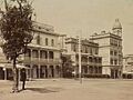
| Looking east up Fitzroy Street to the corner of Grey Street, during the Midsumma Pride March in 2008 | |
| General information | |
| Type | Street |
| Length | 1.1 km (0.7 mi) |
| Major junctions | |
| West end | The Esplanade St Kilda, Melbourne |
|
|
| East end | St Kilda, Melbourne |
| Location(s) | |
| LGA(s) | City of Port Phillip |
Fitzroy Street is a main road in St Kilda, a lively beachside suburb of Melbourne. This street has changed a lot over the years. It started as a fancy area with big houses. Later, it became a popular spot for entertainment and beach fun.
In recent times, Fitzroy Street has seen more changes. It was once famous for its many restaurants. Now, you can find a mix of shops, including kebab places and convenience stores. The street is named after Charles Augustus FitzRoy. He was the Governor of New South Wales in 1842. At that time, Victoria was part of New South Wales.
Contents
Exploring Fitzroy Street's Path
Fitzroy Street is a wide road that goes downhill. It stretches from St Kilda Junction all the way to the beach. This street is the most direct way to get from Melbourne's city center to the popular bay beach. It has very wide footpaths and special lanes for trams. The two sides of the street have different looks and feels. Sometimes, the street is closed to cars for big events. These events include the St Kilda Festival and the Midsumma Pride March.
East Side: Junction to Grey Street
The eastern part of Fitzroy Street starts at St Kilda Junction. It goes to Grey Street. On the south side, you'll see medium-sized apartment buildings. These buildings look out over Albert Park and Lake and the Junction Oval. The corner of Grey Street is home to a large building called The George. It used to be a big hotel but now has apartments and places to eat.
West Side: Grey Street to The Esplanade
From Grey Street to The Esplanade, the south side of the street is full of shops. Many of these shops have apartments or hotels above them. One famous place is Leo's Spaghetti Bar. It's an old Italian restaurant and ice cream shop. It first opened during the 1956 Summer Olympics.
Across from The George building is the old St Kilda railway station. It opened in 1857. In 1987, the train line became part of Tram Route 96. The old station building now has shops and other businesses. Tram routes 16 and 96 both travel along Fitzroy Street.
A Look Back at Fitzroy Street's Past
Like St Kilda itself, Fitzroy Street was a wealthy area in the mid to late 1800s. It had grand houses, fancy terraces, and hotels. Between World War I and World War II, many of these large homes changed. They became flats or private hotels. Shops were built in their front gardens. Other old buildings were replaced by new flats with shops on the ground floor. The well-known Art Deco style Prince of Wales Hotel was built in 1937. It replaced an older hotel on the corner of Acland Street. This trend of building shops continued into the mid-1900s.
A Hub for Community and Culture
From the 1960s to the 1980s, Fitzroy Street became a lively place. It was known for late-night eateries and entertainment. It also became a center for different music scenes, like punk rock and alternative music. Venues like the Crystal Ballroom and the Prince of Wales Hotel were popular.
In the 1980s, the street and especially the Prince of Wales Hotel became important for Melbourne's diverse community. This connection continues today. The Midsumma Festival has been held here since 1995. In 2017, it was announced that the Victorian Pride Centre would be built in the area. This center is a place for community groups and services.
In March 2017, the Gatwick Private Hotel was bought by the Nine Network. They used it for filming the 2018 season of The Block, a popular TV show.
Road Management Changes
The Road Management Act 2004 gave VicRoads the job of managing Victoria's main roads. In 2013, VicRoads officially named part of the road Fitzroy Street (Arterial #5932). This section starts at Canterbury Road and ends at Nepean Highway in St Kilda. The part of the street closer to The Esplanade is not part of this official declaration.
Images for kids
-
Looking towards Grey Street along Fitzroy Street from Albert Park in 1890. You can see the buildings that made up the Terminus (now the George) Hotel.
-
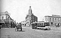
St Kilda Junction in the 1880s. From left to right, you can see Wellington Street, High Street (now St Kilda Road), Barkly Street, and Fitzroy Street. The tram tracks turning into Fitzroy Street are visible.


See also
