Flagstaff, Victoria facts for kids
Quick facts for kids FlagstaffVictoria |
|
|---|---|
| Established | 1854 |
| Postcode(s) | 3465 |
| LGA(s) | Shire of Central Goldfields |
| State electorate(s) | Ripon |
| Federal Division(s) | Mallee |
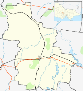
Flagstaff is a small area in Victoria, Australia. It used to be a settlement, or a place where people lived. You can find it on the Pyrenees Highway, east of Maryborough. It's part of the Shire of Central Goldfields. Flagstaff is about 218 meters above sea level. The land here naturally has a special type of forest called a Box-Ironbark forest. You can still find signs of the original Aboriginal people who lived here, like old rock wells and sculptures.
In 2021, a count showed that 97 people lived in Flagstaff. This was a small increase of 10 people since 2016.
Contents
The Story of Flagstaff
Flagstaff began as a place where people came to mine for gold. The settlement stretched for about 4.8 kilometers along a local creek.
Early Days and the School
A state school opened in Flagstaff in 1868. It taught children for many years until it closed in 1939. The school building is still standing today. After the school closed, it became a community hall. People still use it for dances and other community events.
The Gold Rush Begins
Gold was first officially found in Flagstaff in January 1855. This discovery got a lot of attention in the news. More gold was found in June 1855, which brought many prospectors (people looking for gold) to the area. At one point, there were seven local pubs (places to eat and drink) in Flagstaff!
A much bigger gold rush happened in Maryborough starting in June 1854. However, some miners had already been working in that area since December of the year before. The number of people in Maryborough grew very quickly. It went from 120 people to 2,700 in just one month. By August 1854, the population had jumped from 7,000 to 20,000!
How Flagstaff Got Its Name
Seven men were camping near Maryborough on their way to the gold rush. One of these men was named Murray Neppy. They found gold at a nearby place called Carisbrook. Neppy really liked the name Flagstaff. So, he decided to name the new township after it.
The goldfields around Flagstaff were just a small part of a much larger area rich in gold. Many miners came to these goldfields, following the latest discoveries. The area produced a lot of gold over time.
 | Laphonza Butler |
 | Daisy Bates |
 | Elizabeth Piper Ensley |


