Forest Hill, Maryland facts for kids
Quick facts for kids
Forest Hill, Maryland
|
|
|---|---|

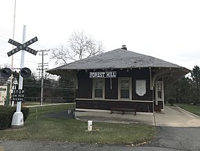
Forest Hill Train Station along the former Ma & Pa Railroad (December 2021)
|
|
| Country | United States |
| State | Maryland |
| County | Harford |
| Elevation | 577 ft (176 m) |
| Population
(2021)
|
|
| • Total | 18,202 |
| Time zone | UTC-5 (Eastern (EST)) |
| • Summer (DST) | UTC-4 (EDT) |
| ZIP code |
21050
|
| Area code(s) | 410, 443 |
| FIPS code | 24-24025 |
| GNIS feature ID | 584446 |
| Other name | Foresthill |
Forest Hill is a community in Harford County, Maryland, United States. It is called an "unincorporated community" because it doesn't have its own city government. Instead, it is part of the larger county.
Forest Hill is located north of Bel Air, which is the county seat. The main part of Forest Hill is where two roads, Maryland Route 24 and Jarrettsville Road, meet.
Years ago, until 1958, a train line called the Maryland and Pennsylvania Railroad served this community.
The area covered by Forest Hill's ZIP code is quite large. It includes both open rural land and more developed suburban areas. These suburban parts are close to the larger town of Bel Air.
History and Landmarks
Forest Hill is home to St. Ignatius Church. This historic church was added to the National Register of Historic Places in 1974. This means it's recognized as an important place in American history.
Where is Forest Hill Located?
Forest Hill is in Maryland, United States. It is located at about 39.58 degrees North latitude and 76.38 degrees West longitude. This community sits at an elevation of 577 feet (or 176 meters) above sea level.
People and Homes in Forest Hill
According to the 2000 census, about 14,951 people lived in the Forest Hill area. This included 7,234 men and 7,717 women. There were also 5,459 homes in the community. The land area of Forest Hill is about 29.89 square miles (or 77.41 square kilometers).
 | Calvin Brent |
 | Walter T. Bailey |
 | Martha Cassell Thompson |
 | Alberta Jeannette Cassell |


