
Bel Air, Maryland facts for kids
Quick facts for kids
Bel Air, Maryland
|
|||||
|---|---|---|---|---|---|
| Town of Bel Air | |||||

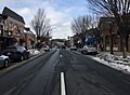
Bel Air's South Main Street in December 2021
|
|||||
|
|||||

Location of Bel Air, Maryland
|
|||||

Bel Air, Maryland
Location in Maryland

Bel Air, Maryland
Location in the United States

Bel Air, Maryland
Location in North America
|
|||||
| Country | |||||
| State | |||||
| County | |||||
| Founded | 1780 | ||||
| Incorporated | 1874 | ||||
| Government | |||||
| • Type | Council-Manager | ||||
| Area | |||||
| • Town | 3.04 sq mi (7.88 km2) | ||||
| • Land | 3.03 sq mi (7.85 km2) | ||||
| • Water | 0.01 sq mi (0.02 km2) | ||||
| Population
(2020)
|
|||||
| • Town | 10,661 | ||||
| • Density | 3,517.32/sq mi (1,357.84/km2) | ||||
| • Urban | 214,647 (US: 180th) | ||||
| • Urban density | 2,002.3/sq mi (773.1/km2) | ||||
| Time zone | UTC−5 (Eastern (EST)) | ||||
| • Summer (DST) | UTC−4 (EDT) | ||||
| ZIP Codes |
21014, 21015
|
||||
| Area codes | 410, 443, and 667 | ||||
| FIPS code | 24-05825 | ||||
| Website | Bel Air, Maryland | ||||


Bel Air is a town in Maryland, USA. It is the main town, or county seat, of Harford County. In 2020, about 10,661 people lived in Bel Air.
Bel Air is also part of a larger developed area. This area, which includes nearby Aberdeen, had a population of over 214,000 people in 2020. This makes it one of the bigger urban areas in the United States.
Contents
History of Bel Air
Bel Air has changed its name a few times since it started in 1780. A man named Aquilla Scott owned the land. He planned the town on a part of his land called "Scott's Old Fields."
Just four years later, the town grew. Local leaders and business owners bought land from Scott. The county decided to change the town's name to "Belle Aire." Later, the spelling changed to "Bell Aire," and then finally to "Bel Air" around 1798.
Becoming the County Seat
In 1782, Bel Air became the county seat for Harford County. This meant it was the main center for government. Daniel Scott, Aquilla's son, started building a courthouse on Main Street.
At first, Bel Air was mostly just two sides of Main Street. But after the American Civil War, the town started to grow a lot. New buildings were built, and more land was developed.
Growth and Development
Bel Air was officially made a town in 1874. It began with only 42 lots along Main Street. These lots were around the courthouse and the county jail. By 1865, about 200 people lived there.
The town's growth really sped up after the Civil War. New industries like canning and the "Ma & Pa" railroad helped the town expand. Bel Air became an important place for government and business in the county.
Since 1980, Bel Air and its nearby areas have grown even more. Today, it is the main hub for government, schools, culture, healthcare, and businesses in Harford County.
Fires in Downtown Bel Air
Over the years, several large fires have happened in downtown Bel Air. Major fires occurred in 1900 and 1942. Another big fire in 1972 destroyed part of Main Street. It caused about $2 million in damage.
Historic Places
Many important historical buildings and sites in Bel Air are listed on the National Register of Historic Places. These places help preserve the town's history. Some examples include:
- Bel Air Armory
- Bel Air Courthouse Historic District
- Hays House
- Liriodendron
- Tudor Hall
Geography and Climate
Bel Air covers about 3.03 square miles (7.85 square kilometers) of land. Only a very small part is water.
Weather in Bel Air
Bel Air has a humid subtropical climate. This means it has:
- Hot and often humid summers.
- Mild and wet springs.
- Pleasant autumns.
- Cool to chilly winters.
On average, Bel Air gets about 40-43 inches of rain each year. It also gets about 19-24 inches of snow.
Population Information
| Historical population | |||
|---|---|---|---|
| Census | Pop. | %± | |
| 1850 | 255 | — | |
| 1860 | 197 | −22.7% | |
| 1870 | 633 | 221.3% | |
| 1890 | 1,416 | — | |
| 1900 | 961 | −32.1% | |
| 1910 | 1,005 | 4.6% | |
| 1920 | 1,091 | 8.6% | |
| 1930 | 1,650 | 51.2% | |
| 1940 | 1,885 | 14.2% | |
| 1950 | 2,578 | 36.8% | |
| 1960 | 4,300 | 66.8% | |
| 1970 | 6,307 | 46.7% | |
| 1980 | 7,814 | 23.9% | |
| 1990 | 8,860 | 13.4% | |
| 2000 | 10,080 | 13.8% | |
| 2010 | 10,120 | 0.4% | |
| 2020 | 10,661 | 5.3% | |
| 2021 (est.) | 10,715 | 5.9% | |
| U.S. Decennial Census | |||
In 2010, there were 10,120 people living in Bel Air. The town had 4,491 households. The average age of people in Bel Air was about 40 years old.
About 20.5% of the people were under 18 years old. About 18.4% were 65 years or older.
Getting Around Bel Air
Highways and Roads
_just_north_of_U.S._Route_1_Business_(Baltimore_Pike)_in_Bel_Air,_Harford_County,_Maryland.jpg)
Most people travel to and from Bel Air by car. Maryland Route 24 is the main highway. It connects Bel Air to U.S. Route 1 and Interstate 95.
U.S. Route 1 Business goes through downtown Bel Air. Maryland Route 22 connects Bel Air directly to Aberdeen.
Bel Air is about:
- 27 miles northeast of Baltimore.
- 66 miles northeast of Washington, D.C..
- 78 miles southwest of Philadelphia.
- 167 miles southwest of New York City.
Airports for Small Planes
There are three small airports nearby:
- Forest Hill Industrial Airpark
- Fallston Airport
- Harford County Airpark
Old Railroad Tracks
In the mid-1900s, the Maryland and Pennsylvania Railroad (called "Ma and Pa") ran through Bel Air. The tracks were removed in 1958. Today, much of the old railroad path is now the Ma and Pa Trail. This is a popular walking trail that goes through wooded areas of the town.
Bus Services
Harford Transit LINK is the main bus service in Bel Air and Harford County. It has seven routes. The Orange Line, for example, is the "Bel Air Circulator" and travels around the town.
Other routes connect to places like Edgewood and Aberdeen. The Harford Mall is the main place where people can switch between bus routes.
Law Enforcement
The Bel Air Police Department is in charge of keeping the town safe. It was started in 1874. Its main office is on N. Hickory Avenue.
Culture and Arts
Bel Air has a special "arts and entertainment district." This area covers about 99 acres in downtown Bel Air. It is used for:
- Concerts
- Art galleries
- Other fun events
Famous People from Bel Air
Many notable people have connections to Bel Air:
- John Archer (1741–1810) – A politician and doctor.
- Lisa Aukland – A professional bodybuilder.
- Andrew Berry – A professional football manager.
- Elijah Bond – The inventor of the ouija board.
- Edwin Booth – A famous actor from the 1800s.
- John Wilkes Booth – An American stage actor.
- Augustus Bradford – The 32nd Governor of Maryland.
- Pat Healey – A professional soccer player.
- Julienne Irwin – A singer who was a finalist on America's Got Talent.
- Chase Kalisz – An Olympic swimmer who won a silver medal in 2016.
- Howard Atwood Kelly – A pioneering doctor at Johns Hopkins University School of Medicine.
- Kimmie Meissner – An Olympic figure skater and World Champion.
- Melvin Mora – A former Baltimore Orioles baseball player.
- Herman Stump – A Congressman.
- Drew Westervelt – A professional lacrosse player.
- Jay Witasick – A Major League Baseball pitcher.
- Brandon Scott Jones – An American actor.
Images for kids
-
Bel Air's South Main Street in December 2021
-

Flag of Bel Air
-
Seal of Bel Air
-
Coat of arms of Bel Air
-

Wordmark of Bel Air
-

Location of Bel Air, Maryland

See also
 In Spanish: Bel Air (condado de Harford, Maryland) para niños
