Forks of Waters, Virginia facts for kids
Quick facts for kids
Forks of Waters, Virginia
|
|
|---|---|

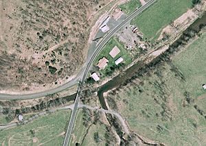
Aerial view of Forks of Waters. The South Branch Potomac River flows diagonally across the image.
|
|
| Country | United States |
| State | Virginia |
| County | Highland |
| Elevation | 2,313 ft (705 m) |
| Time zone | UTC−5 (Eastern (EST)) |
| • Summer (DST) | UTC−4 (EDT) |
| ZIP codes |
24465
|
| GNIS feature ID | 1483492 |
Forks of Waters is a small place in Highland County, Virginia, United States. It's called an "unincorporated community." This means it's a group of homes and businesses that don't have their own local government like a city or town. Instead, it's part of the larger county. Forks of Waters was once known as Strait Creek.
About Forks of Waters
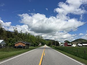
Forks of Waters is located in the beautiful mountains of Virginia. It sits about 6 miles (10 km) northeast of a town called Monterey, Virginia. The community is found where two important roads meet: U.S. Route 220 and Virginia State Route 642.
Why the Name "Forks of Waters"?
The name "Forks of Waters" tells you something special about this place. It's named because two waterways come together here. A stream called Strait Creek flows into the South Branch Potomac River right near the community. This meeting point of the two waters gives the area its unique name.
Where the River Flows
After passing through Forks of Waters, the South Branch Potomac River continues its journey. It flows about 1 mile (1.6 km) northeast before crossing into West Virginia. This makes Forks of Waters an interesting spot on the river's path.
 | Selma Burke |
 | Pauline Powell Burns |
 | Frederick J. Brown |
 | Robert Blackburn |


