
Fort Denison facts for kids
Quick facts for kids Fort Denison |
|
|---|---|
|
Mattewanye (Dharuk)
|
|

Fort Denison pre-1885.
(Image: National Archives of Australia) |
|
| Former names | Pinchgut |
| Etymology | Sir William Thomas Denison |
| General information | |
| Status | Built as a fortress. Decommissioned circa 1930s. Now used as a national park; reserve; tourist facility; function space |
| Type | Military fortress; gunnery |
| Architectural style | Colonial fortification, castellated style |
| Location | Sydney Harbour |
| Address | North of Woolloomooloo |
| Construction started | 1841 |
| Completed | 14 November 1857 |
| Closed | circa 1930s |
| Height | |
| Observatory | Martello tower |
| Technical details | |
| Material | Sydney sandstone |

Fort Denison with its Martello tower
|
|
| Lua error in Module:Location_map at line 420: attempt to index field 'wikibase' (a nil value). | |
| Location | Port Jackson, Sydney Harbour National Park |
| Nearest city | Sydney |
| Operator | NSW National Parks & Wildlife Service |
| Official name: Fort Denison; Pinchgut; Mattewanye (Eora name) | |
| Type: | State heritage (built) |
| Designated: | 2 April 1999 |
| Reference #: | 985 |
| Type: | Fortification |
| Category: | Defence |
| Builders: | William Randle |
| Official name: Fort Denison, Sydney, NSW, Australia | |
| Designated: | 21 March 1978 |
| Reference #: | 1856 |
Fort Denison is a small island in Sydney Harbour, New South Wales, Australia. It's part of the Sydney Harbour National Park. This historic site was once a place for prisoners and later became a military fort.
The island is also known by its original Eora language name, Mattewanye, or as Pinchgut Island. Today, it's a protected national park, a tourist spot, and a place for special events. It also has a time signal gun, navigational aids, and tide gauges.
Contents
History of Fort Denison
Before Europeans arrived, the Eora people called the island Mattewanye.
Pinchgut: The Island Prison
| Location | Sydney Harbour, New South Wales, Australia |
|---|---|
| Status | Closed |
| Security class | Maximum; isolation |
| Opened | 1788 |
| Former name | Rock Island |
| Managed by | New South Wales Colonial Government |
When the First Fleet arrived in 1788, Governor Phillip called it "Rock Island." Soon, it became known as "Pinchgut." This name came from the harsh punishments given to convicts there. They were often left with very little food, just bread and water.
Convicts also worked on the island. They quarried Sydney sandstone to help build Circular Quay nearby. This work made the island much flatter than its original 15-meter height.
In 1796, a gibbet (a structure used to display bodies as a warning) was placed on Pinchgut. A convict named Francis Morgan was displayed there after being executed for a crime. He famously said the view of the harbour from the island was "superb."
Building a Military Fortress
In 1839, two American warships sailed into Sydney Harbour at night. This made the government worried about foreign attacks. They decided to build a fort on Pinchgut Island to protect the harbour.
Construction started in 1841 but stopped for a while. It began again in 1855 because people feared a Russian attack during the Crimean War. The fort was finished on November 14, 1857. It was then named Fort Denison after Sir William Thomas Denison, who was the Governor of New South Wales.
The Unique Martello Tower
Fort Denison has a special Martello tower. It's the only one ever built in Australia and the last one constructed in the British Empire. The tower was made from 8,000 tonnes of sandstone. Its walls are very thick, ranging from 3.3 to 6.7 meters at the bottom.
The tower had rooms for 24 soldiers and one officer. It was armed with three large cannons inside. However, by the time the fort was completed, new artillery made it less effective. The cannons inside the tower were hard to use because the passages were too narrow, and their recoil was too strong for the small room.
In 1906, a saluting gun was moved to Fort Denison. In 1913, a lighthouse beacon replaced one of the large guns on the tower's roof. This light, called Fort Denison Light, is still used today.
World War II Incident
In May 1942, three Japanese mini-submarines attacked Sydney Harbour. During the battle, shells from a US Navy cruiser accidentally hit Fort Denison. The tower suffered minor damage, which you can still see today.
A Famous Prank
In October 1900, during the Second Boer War, a young officer named Charles Lightoller played a prank. He and two friends rowed to Fort Denison. They climbed the tower, raised a makeshift Boer flag, and fired a harmless wad of cotton from one of the cannons. The blast broke some windows but caused no other damage.
Lightoller was never caught for the prank. He later became the second officer on the famous ship, the RMS Titanic. He was the most senior officer to survive its sinking in 1912.
Fort Denison Today

Since 1992, the NSW National Parks & Wildlife Service has worked to preserve and improve Fort Denison. They have spent a lot of money to keep the historic site in good condition. These efforts have won several awards.
The island is now home to over 100 birds. Fort Denison – Muddawahnyuh is currently closed to visitors for important upgrades and conservation work. It is expected to reopen in mid-2025.
When open, Fort Denison is a museum, a tourist attraction, and a popular spot for events. Visitors can learn about the island's history, from Aboriginal times to its use as a fort. Ferries usually take visitors from Circular Quay. Guided tours of the island and the Martello tower are also available.
The lighthouse beacon is still working, helping ships navigate the harbour. The Bureau of Meteorology also uses the island to collect weather information.
The Daily Gun Firing
Since 1906, a gun has been fired daily at 1 pm. This tradition helped sailors set their ship's clocks accurately. The practice stopped during World War II to avoid alarming residents. It started again in 1986 and continues today.
Island Features and Design
Fort Denison is a unique landmark in Sydney Harbour. It looks more like a built structure than a natural island now. However, you can still see some of the original sandstone bedrock.
The fort's design combines the tall Martello tower with lower barracks and battery buildings. This shows how it was built in different stages.
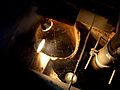
- The Fort: The tower has two internal levels. The lower level stored gunpowder and supplies. The middle level still holds the three original cannons. A spiral staircase connects the levels.
- Gun Battery and Bastion: This part of the fort faced the open water to defend against ships. It has nine gun placements and a bastion (a projecting part of a fortification) with a revolving cannon.
- Wet Ditch and Breakwater: A ditch and a breakwater made of sandstone blocks protect the fort from waves.
- Barracks: This single-story building has eight chimneys. It provided accommodation for soldiers and officers. It also has special angled openings called loopholes for defense.
- Terrace: The lower terrace faces away from the open sea. It has some small garden beds and two sewerage treatment units hidden within them.
- Plantings: The only trees on Fort Denison are a Canary Island date palm and a fig tree.
Condition and Changes
As of August 2025, Fort Denison is in excellent physical condition. It is considered one of the most intact Martello towers in the world.
Over the years, the fort has seen several changes:
- 1840–1842: Initial construction of the battery.
- 1856–1858: Construction of the main battery, barracks, tower, and bastion.
- 1858–1862: Addition of the terrace, west room, and tide gauge room.
- 1917: Construction of a slipway.
Heritage Listing
Fort Denison was added to the New South Wales State Heritage Register on April 2, 1999. This means it is recognized as an important historical site.
Measuring the Tides

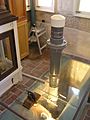
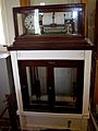
Tides have been measured at Fort Denison since 1857. Over time, different instruments have been used as technology improved. The Bureau of Meteorology has graphed these measurements since 1914.
The island has special equipment called a tide gauge. It uses a float system in a well to measure the water level. While the old system is now a museum exhibit, a modern system continues to record tide heights. Fort Denison's tide measurements are very important. They are the main reference for all published tide information in New South Wales.
Images for kids
-
Tide gauge installation: old and new
-
Obsolete instruments
-
Historic and current (right) stilling wells.
-
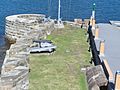
Viewing from tower to southern bastion
-
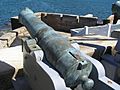
Gun – southern bastion
-
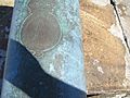
Gun inscription: Honi soit qui mal y pense
-
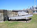
Gun at east-facing wall
-
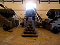
Gun room in the Martello tower


See also
- Punishment in Australia
