Fort Watauga facts for kids

Fort Watauga, also known as Fort Caswell, was an important fort during the American Revolutionary War. It stood near the Watauga River in what is now Elizabethton, Tennessee. Settlers built the fort in 1775–1776 to protect themselves from attacks by Native American tribes, especially the Cherokee. The British government sometimes encouraged these attacks. The fort was first named Fort Caswell after North Carolina Governor Richard Caswell.
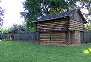
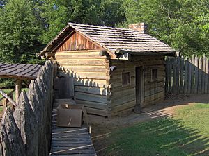
In the 1970s, for the United States Bicentennial (America's 200th birthday), Tennessee decided to rebuild Fort Watauga. Experts studied the area and found old trenches that were likely part of the fort's walls. They used this information, along with old descriptions and common designs of frontier forts, to reconstruct it. Today, the rebuilt fort is part of Sycamore Shoals State Historic Park.
Contents
History of Fort Watauga
Early Settlers Arrive
In the late 1760s, European-American settlers began moving into the valleys of the Holston River, Watauga River, and Nolichucky River. These areas are now in Southwest Virginia and Northeast Tennessee. Many settlers were drawn to a spot called the Watauga Old Fields. This was an ancient gathering place for Native Americans, even before the Cherokee.
The Old Fields had flat, clear land along the Watauga River's Sycamore Shoals. This was a shallow part of the river, making it easy for people to cross. The new settlers often clashed with the Cherokee and other Native American tribes. These tribes considered the land their hunting grounds.
Land Disputes and Treaties
A rule from 1763, called the Royal Proclamation of 1763, set a boundary for British lands. It said settlers should not go past the South Fork of the Holston River. In the early 1770s, settlers living beyond this line, including those at Watauga, were told to leave.
In 1772, the Watauga settlers leased their land from the Cherokee. Then, in 1775, they bought the land. However, these agreements still went against the 1763 Proclamation. A young Cherokee chief named Dragging Canoe strongly disagreed with selling tribal lands. He warned the settlers that there would be fighting. British and North Carolina leaders also told the settlers to leave Cherokee lands.
Cherokee Invasion of 1776
The American Revolutionary War began in 1775. This made the situation on the frontier even more tense. The Watauga settlers supported breaking away from Britain. They formed a group called the "Committee of Safety" and created the "Washington District."
In January 1776, Dragging Canoe and the British formed an alliance. In April, the British gave the Cherokee many weapons. They hoped the Cherokee would attack the colonial frontier. The Cherokee then sent a message to the Watauga settlers. They gave them 20 days to leave or face an attack.
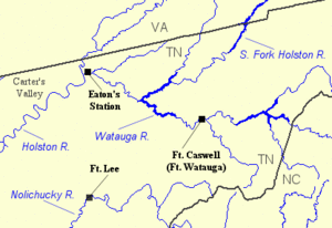
The Watauga settlers expected the Cherokee invasion. They bought weapons and ammunition. They also gathered food and medicine. Several forts were built or made stronger, including Fort Caswell (Fort Watauga). In early July, a Cherokee woman named Nancy Ward warned a trader named Isaac Thomas about the invasion plans. Thomas quickly told John Sevier, who was building Fort Lee. The news scared the settlers, and most of them fled to Fort Caswell. Sevier also had to leave Fort Lee unfinished.
The Cherokee invasion started in mid-July 1776. One group, led by "The Raven," went to Carter's Valley. They chased away settlers and burned their homes. Two other groups, led by Dragging Canoe and Old Abraham of Chilhowee, burned the abandoned Fort Lee. Then, Dragging Canoe went north to attack settlements on the Holston River. Old Abraham went east to attack Fort Watauga.
Dragging Canoe's force met settlers at Eaton's Station. The settlers, led by Captain John Thompson, fought them at Island Flats. Thirteen Cherokee warriors were killed, and many, including Dragging Canoe, were hurt. The Cherokee force then retreated.
The Siege of Fort Caswell
As the Cherokee approached, about 150 to 200 settlers crowded into Fort Caswell. The fort had about 75 defenders. They were led by John Carter, with James Robertson and John Sevier helping him.
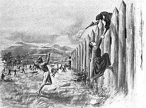
Old Abraham of Chilhowee's Cherokee warriors arrived at Fort Caswell early on July 21. Their sudden appearance surprised several women who were milking cows outside. They rushed to get back inside the fort. One woman, Catherine "Bonnie Kate" Sherrill, who would later marry John Sevier, couldn't get in before the gate was locked. Sevier had to pull her over the fort's tall wooden walls.
The first Cherokee attack lasted about three hours. Both sides fired their guns. Some Cherokee warriors got close enough to try and set the fort on fire. But Ann Robertson Johnson, James Robertson's sister, threw scalding hot water at them, forcing them back.
Since they couldn't take the fort, the Cherokee stopped their direct attack. They began a long siege instead. This meant they surrounded the fort, trying to starve out the people inside. During the siege, a teenager named Tom Moore was captured outside the fort. He was taken to a Cherokee town and killed. Another captive, Lydia Russell Bean, was about to suffer the same fate. But Nancy Ward, a respected Cherokee woman, stepped in and used her power to save her.
After about two weeks, the Cherokee ended the siege and left. Later that year, the Virginia militia arrived, which greatly reduced the threat to the fort.
Fort Watauga in Later Years
In September 1780, a group of frontier fighters called the Overmountain Men gathered at Sycamore Shoals. They were on their way to fight British loyalists at the Battle of Kings Mountain, which they won.
After this event, Fort Watauga was rarely mentioned in historical records. However, it still appeared in land documents as late as 1819.
In 1909, the Daughters of the American Revolution placed a monument near where they believed the fort stood. In the mid-1970s, Tennessee rebuilt the fort for the nation's 1976 bicentennial. The state paid for archaeological digs and historical research to figure out the fort's design and exact spot. A group called the Watauga Historical Association, formed in the late 1950s, played a big part in creating Sycamore Shoals State Historic Park.
Fort Location and Design
Finding the Fort's Location
A historian named J. G. M. Ramsey wrote about Fort Watauga's location in 1852. He visited Elizabethton and thought he saw the fort's remains. Ramsey said the fort was about 0.5 miles (0.8 km) northeast of Gap Creek's mouth. This is now near the intersection of West G Street and Monument Place, where the 1909 D.A.R. monument stands.
Another historian, Lyman Draper, had a different idea about the fort's location. He believed it was about 1 mile (1.6 km) downstream from the Doe River's mouth. This spot is about 2 miles (3.2 km) northeast of Ramsey's location. It is now in the outfield of Joe O'Brien Field, south of the Watauga River.
The Ramsey location places the fort two miles farther west from the homes of John Carter, John Sevier, and James Robertson. These men were leaders and defenders during the 1776 Cherokee siege. James Robertson built his home in 1770-1771 along the north side of the Watauga River. Draper also noted that Fort Watauga was about four miles from John Sevier's plantation. Sevier's home was near Stoney Creek, south of the Watauga River.
What the Fort Looked Like
Not much is known about the original design of Fort Watauga. Ramsey described the fort as being on a small hill. Draper wrote that the fort was surrounded by an open grassy area. This area was within easy firing distance of the Watauga River's north bank.
In 1974, state archaeologists found partial trench-like shapes about 300 feet (91 m) west of the D.A.R. marker. Carl Kuttruff, a state archaeologist, thought these were the remains of Fort Watauga. This was based on Ramsey's description.
The 1974 excavations showed that the fort had an irregular shape. It likely had several cabins connected by a stockade (a fence of sharpened poles). The shape of the rebuilt fort is based on these findings. Its design is also based on other frontier forts from that time. These forts usually had log buildings, some with second stories that hung over. They also had a stockade of sharpened poles surrounding a courtyard of about 1 acre (0.4 ha). The reconstructed fort today is about 1500 yards (1372 m) northeast of Ramsey's location. It is about a mile west of Draper's location.
 | William M. Jackson |
 | Juan E. Gilbert |
 | Neil deGrasse Tyson |


