Foss, Oregon facts for kids
Quick facts for kids
Foss
|
|
|---|---|

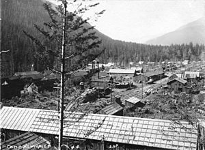
Camp Nehalem
|
|
| Country | United States |
| State | Oregon |
| County | Tillamook |
| Elevation | 49 ft (15 m) |
| Time zone | UTC-8 (Pacific (PST)) |
| • Summer (DST) | UTC-7 (PDT) |
| Area code(s) | 503 and 971 |
| GNIS feature ID | 1120902 |
Foss is a small, quiet place in Tillamook County, Oregon, in the United States. It's not a city or town with its own government, but rather an unincorporated community. You can find it about 4 miles (6.4 km) east of Mohler, close to the Nehalem River. Foss is important because it has a special device that measures how high the river water is during floods.
Foss got its name from a man named Herbert Foss. He owned a lot of timber (trees used for wood) in this area. A post office operated in Foss from 1928 to 1943. A train station for the Southern Pacific Railroad (now the Port of Tillamook Bay Railroad) was also set up there.
A place called Camp Nehalem, sometimes known as Camp Foss, was located northeast of Foss. This camp was part of the Civilian Conservation Corps (CCC). The CCC was a program during the Great Depression that helped young men find work. They built things like parks and roads. Camp Nehalem used Foss as its mailing address.
Geography of Foss
Foss is a small area, covering only about 474 acres. It is located in the northwestern part of Oregon. This community sits at a low elevation, close to the Pacific Ocean. It is surrounded by the tall mountains of the Oregon Coastal Range.
Climate and Weather
Foss has a unique climate that is a mix of cool-summer Mediterranean and oceanic weather. This means it has cool temperatures and a lot of rain during the cooler months. From October to April, Foss gets a huge amount of rain, often more than 12 inches (30 cm) each month. It doesn't snow much, usually only about 2 inches (5 cm) per year.
Summers in Foss are mild and sometimes warm. July and August are the driest months, with very little rain. Because Foss is at a low elevation and surrounded by high mountains near the ocean, a lot of moisture gets trapped in the area. This is why it receives so much heavy rainfall throughout the year.
| Climate data for Foss, Oregon (1981–2010) | |||||||||||||
|---|---|---|---|---|---|---|---|---|---|---|---|---|---|
| Month | Jan | Feb | Mar | Apr | May | Jun | Jul | Aug | Sep | Oct | Nov | Dec | Year |
| Mean daily maximum °F (°C) | 51.1 (10.6) |
52.2 (11.2) |
54.1 (12.3) |
56.8 (13.8) |
60.0 (15.6) |
63.7 (17.6) |
68.0 (20.0) |
68.5 (20.3) |
68.1 (20.1) |
62.0 (16.7) |
55.7 (13.2) |
49.6 (9.8) |
59.2 (15.1) |
| Mean daily minimum °F (°C) | 38.8 (3.8) |
39.2 (4.0) |
39.5 (4.2) |
41.4 (5.2) |
44.7 (7.1) |
50.2 (10.1) |
51.7 (10.9) |
51.0 (10.6) |
48.6 (9.2) |
45.5 (7.5) |
42.3 (5.7) |
38.6 (3.7) |
44.3 (6.8) |
| Average precipitation inches (mm) | 15.71 (399) |
11.58 (294) |
15.44 (392) |
11.00 (279) |
5.63 (143) |
3.82 (97) |
0.90 (23) |
1.22 (31) |
4.40 (112) |
12.08 (307) |
18.36 (466) |
17.44 (443) |
117.58 (2,986) |
| Average snowfall inches (cm) | 0.8 (2.0) |
0.7 (1.8) |
0.1 (0.25) |
0.0 (0.0) |
0.0 (0.0) |
0.0 (0.0) |
0.0 (0.0) |
0.0 (0.0) |
0.0 (0.0) |
0.0 (0.0) |
0.0 (0.0) |
0.8 (2.0) |
2.4 (6.05) |
| Source: NOAA | |||||||||||||
 | Emma Amos |
 | Edward Mitchell Bannister |
 | Larry D. Alexander |
 | Ernie Barnes |


