Fountains Fell Tarn facts for kids
Quick facts for kids Fountains Fell Tarn |
|
|---|---|

Fountains Fell Tarn
|
|
| Location | Fountains Fell, North Yorkshire, |
| Coordinates | 54°08′13″N 2°12′07″W / 54.137°N 2.202°W |
| Type | Tarn |
| Etymology | Derived from Fountains Fell |
| Primary inflows | None |
| Primary outflows | Darnbrook Beck Cowside Beck |
| Catchment area | 37 acres (15 ha) |
| Basin countries | England |
| Surface area | 4.9 acres (2 ha) |
| Average depth | 1 foot 8 inches (0.5 m) |
| Water volume | 3,000,000 cubic feet (86,000 m3) |
| Shore length1 | 0.62 miles (1 km) |
| Surface elevation | 2,116 feet (645 m) |
| 1 Shore length is not a well-defined measure. | |
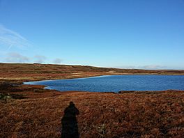
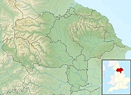
Fountains Fell Tarn is a small lake high up in the mountains, located between the two peaks of Fountains Fell in North Yorkshire, England. A "tarn" is a special name for a mountain lake, often formed by glaciers. This tarn is near the famous Pennine Way walking path. It's about 7 kilometers (4.3 miles) northwest of Malham Tarn and 7 kilometers (4.3 miles) east of Horton in Ribblesdale.
Water from Fountains Fell Tarn flows eastwards into Cowside Beck. This beck then joins the River Skirfare in Littondale. The water in the tarn itself is quite acidic. However, as it flows off the mountain, it passes over Yoredale limestone. This makes the water become "harder," meaning it becomes more alkaline (the opposite of acidic).
Contents
What is Fountains Fell Tarn Like?
Fountains Fell Tarn sits in a shallow bowl-shaped area. This shape was carved out by glaciers during the Devensian Ice Age, which scraped away the limestone rock. Malham Tarn was formed in a similar way. The removal of porous limestone allowed water to collect and form these lakes.
Even though the tarn doesn't always have water flowing out, during heavy rain, water drains eastwards. This water forms Cowside Beck, which flows into the River Skirfare. The water in the tarn is quite acidic because of the local peat and the underlying millstone grit rock, not limestone. This gives the water a low "hardness value" (between 3 and 5). However, as the water flows over limestone rocks, it picks up alkalinity. By the time it joins water from Darnbrook Fell, its hardness increases a lot (between 19 and 25).
Fountains Fell has two main peaks. The northern peak is 668 meters (2,192 feet) high, and the southern peak is 662 meters (2,172 feet) high. The tarn itself sits between these two peaks at an elevation of 645 meters (2,116 feet) above sea level. It lies on a flat area surrounded by eroding peat bog, which contributes to its acidity. In the 1950s, it was noted that the bottom of the tarn was mostly sand, with some peat growing into it.
Size and Temperature of the Tarn
Fountains Fell Tarn is quite shallow, with an average depth of only 0.5 meters (1.6 feet). Despite being shallow, it holds a large amount of water, estimated to be about 86,000 cubic meters (3,037,000 cubic feet).
Because of its high location near the top of Fountains Fell, the tarn often freezes for long periods during winter. Between 1949 and 1955, snow fell on average 47 days each year. The average air temperature during this time was about 7 degrees Celsius (45 degrees Fahrenheit). By the period of 1992 to 1997, the average air temperature had slightly risen to 7.2 degrees Celsius (45 degrees Fahrenheit). In 1995, there were at least 129 days of cloud cover.
Animals Living in the Tarn
Scientists have found water bugs and water beetles living in Fountains Fell Tarn. However, freshwater shrimp (called Gammarus pulex) were not found there. This is likely because the tarn has low levels of calcium, which these shrimp need. Interestingly, these shrimp were found in large numbers in the streams and small rivers that flow out from the tarn, where the water has picked up more calcium from the limestone.
The tarn is easy to reach for hikers. The famous Pennine Way walking trail crosses Fountains Fell, passing to the east of the tarn.
How Fountains Fell Tarn Got Its Name
The tarn is named after the mountain it sits on, Fountains Fell. The name "Fountains Fell" was first recorded in 1540. It was named after Fountains Abbey, a famous monastery that owned the rights to graze sheep on the mountain.
The word "tarn" itself is a common name for mountain lakes. It comes from the Old Scandinavian word tjǫrn. The first time the name Fountains Fell Tarn was written down was in 1858.
There is an old cross base called Ulfkil Cross near the tarn. This cross marks the boundary between two old townships, Stainforth and Malham Moors. In old records, the mountain (Fountains Fell) was called Gnup, and the tarn was called Suartecumbe. Sometimes, the lake is simply called Fountains Tarn.
 | Stephanie Wilson |
 | Charles Bolden |
 | Ronald McNair |
 | Frederick D. Gregory |


