Fowlerton, Texas facts for kids
Quick facts for kids
Fowlerton, Texas
|
|
|---|---|

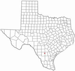
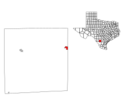
Location of Fowlerton, Texas
|
|
 |
|
| Country | United States |
| State | Texas |
| County | La Salle |
| Area | |
| • Total | 2.18 sq mi (5.64 km2) |
| • Land | 2.17 sq mi (5.62 km2) |
| • Water | 0.004 sq mi (0.01 km2) |
| Elevation | 318 ft (97 m) |
| Population
(2020)
|
|
| • Total | 73 |
| • Density | 33.52/sq mi (12.94/km2) |
| Time zone | UTC−6 (Central (CST)) |
| • Summer (DST) | UTC−5 (CDT) |
| ZIP Code |
78021
|
| Area code(s) | 830 |
| FIPS code | 48-27144 |
| GNIS feature ID | 2408251 |
Fowlerton is a small community in La Salle County, Texas, in the United States. It's called a census-designated place (CDP). This means it's an area that the government defines for counting people. In 2020, about 73 people lived there.
Contents
History of Fowlerton
Fowlerton got its name from two brothers who started the community around 1910. By 1914, the town was quite busy. Its population grew to about 1,000 people. At that time, Fowlerton even had telephone service.
However, farmers in the area faced tough times. There were long periods without rain, called droughts. Also, the prices for their crops were very low. The Fowler brothers, who had encouraged people to move there, soon faced legal problems from unhappy settlers.
By 1925, the number of people living in Fowlerton had dropped to about 600. It never grew back to its earlier size. A railroad, the San Antonio, Uvalde and Gulf Railroad, came through Fowlerton. This brought some good times, but they didn't last very long. Today, this railroad is part of Union Pacific.
Geography of Fowlerton
Fowlerton is located in the northeastern part of La Salle County. It sits right next to McMullen County on its eastern side.
You can find Fowlerton by following Texas State Highway 97. This highway goes north about 29 miles (47 km) to Charlotte. If you go west on Highway 97, it's about 27 miles (43 km) to Cotulla. Another road, Texas State Highway 72, starts about 2 miles (3 km) north of Fowlerton. It goes east about 39 miles (63 km) to Three Rivers.
- San Antonio is about 75 miles (121 km) north of Fowlerton.
- Corpus Christi is about 114 miles (183 km) to the southeast.
- Laredo is about 100 miles (161 km) to the southwest.
The U.S. Census Bureau says that Fowlerton covers a total area of about 2.2 square miles (5.6 square kilometers). Only a tiny part of this area, about 0.004 square miles (0.01 square kilometers), is water. The Frio River flows along the northern edge of the community. This river eventually joins the Nueces River at Three Rivers.
Population Information
| Historical population | |||
|---|---|---|---|
| Census | Pop. | %± | |
| 2020 | 73 | — | |
| U.S. Decennial Census 1850–1900 1910 1920 1930 1940 1950 1960 1970 1980 1990 2000 2010 |
|||
In the year 2000, there were 62 people living in Fowlerton. These people lived in 28 households. About 25% of these households had children under 18 living with them. Most households, about 60%, were married couples.
The average age of people in Fowlerton in 2000 was 46 years old. About 25% of the population was under 18.
Education in Fowlerton
Students in Fowlerton are part of the Cotulla Independent School District. However, most students from Fowlerton choose to go to McMullen County High School in Tilden.
Climate
The weather in Fowlerton has hot and humid summers. The winters are usually mild to cool. This type of weather is known as a humid subtropical climate. On climate maps, it is often labeled as Cfa.
See also
 In Spanish: Fowlerton (Texas) para niños
 | Janet Taylor Pickett |
 | Synthia Saint James |
 | Howardena Pindell |
 | Faith Ringgold |

