
Fox Island, Michigan facts for kids

USGS aerial imagery of Fox Island
|
|

Fox Island
Location in Wayne County, Michigan

Fox Island
Location in Michigan

Fox Island
Location in the United States
|
|
| Geography | |
|---|---|
| Location | Michigan |
| Coordinates | 42°06′21″N 83°08′30″W / 42.10583°N 83.14167°W |
| Highest elevation | 587 ft (178.9 m) |
| Administration | |
|
United States
|
|
| State | |
| County | Wayne |
Fox Island is an island in the Detroit River. It is in Wayne County, in southeast Michigan. Its coordinates are 42°06′21″N 83°08′30″W / 42.10583°N 83.14167°W, and the United States Geological Survey gave its elevation as 587 ft (179 m) in 1980.
Images for kids
-
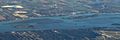
A 2016 aerial photo looking east, with Grosse Ile at bottom and Amherstburg at top. To the top of the Livingstone Channel are Crystal Island (left) and Bois Blanc Island (right). To the bottom are Stony Island (left), Powder House Island (center-left), Fox Island (center-right), and Sugar Island (far right).
-
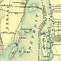
Fox Island, as it appeared on a 1906 USGS map.
,_1906,_1-62500_(cropped_to_Fox_and_Powder_House_Islands).jpg)

All content from Kiddle encyclopedia articles (including the article images and facts) can be freely used under Attribution-ShareAlike license, unless stated otherwise. Cite this article:
Fox Island, Michigan Facts for Kids. Kiddle Encyclopedia.