
Fraubrunnen District facts for kids
Quick facts for kids
Fraubrunnen District
Amtsbezirk Fraubrunnen
|
|
|---|---|
|
District
|
|
 |
|
| Country | |
| Canton | |
| Capital | Fraubrunnen |
| Area | |
| • Total | 124 km2 (48 sq mi) |
| Population
(2007)
|
|
| • Total | 38,895 |
| • Density | 313.7/km2 (812/sq mi) |
| Time zone | UTC+1 (CET) |
| • Summer (DST) | UTC+2 (CEST) |
| Municipalities | 26 |
Fraubrunnen District was a special area, like a county, in Switzerland. It was located in the canton of Bern, which is like a state or region. The main town, or capital, of this district was Fraubrunnen.
The district covered an area of 124 square kilometers (about 48 square miles). In 2007, about 38,895 people lived there. It was made up of 27 smaller towns and villages, called municipalities.
Contents
What Was the Fraubrunnen District?
The Fraubrunnen District was one of 26 administrative districts in the canton of Bern. These districts helped manage local government and services. Think of them like smaller regions within a larger state.
Why Was the District Changed?
On January 1, 2010, the Fraubrunnen District was dissolved. This means it stopped being a separate district. This change was part of a bigger plan to reorganize the districts in the Canton of Bern.
Most of the area that was once the Fraubrunnen District became part of a new, larger district. This new district is called the Emmental district. This kind of change happens sometimes to make government more efficient.
Towns and Villages in the District
Before it was dissolved, the Fraubrunnen District included many different towns and villages. Each of these smaller places had its own local government. Some of the larger towns included Münchenbuchsee, Urtenen-Schönbühl, and Jegenstorf.
These towns and villages varied in size and population. For example, Münchenbuchsee was the largest town with over 9,500 people in 2005. Other places, like Scheunen, were much smaller.
Images for kids
-
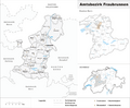
A map showing the Fraubrunnen District in 2007.
See also
 In Spanish: Distrito de Fraubrunnen para niños
