Frederick Reefs facts for kids
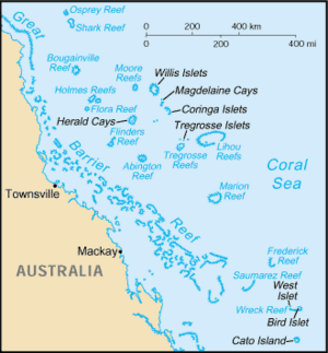
Frederick Reef is a small group of reefs in the Coral Sea Islands. It's located about 220 nautical miles (407 km) northeast of Gladstone, Queensland, Australia. This reef was named after the ship Frederick, which first saw it.
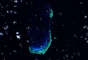
Frederick Reef is like a small atoll, which is a ring-shaped coral reef that surrounds a lagoon. It has a large rock called Ridge Rock and a sand island called Observatory Cay. There's also a lighthouse at the northern end. This lighthouse is on the only part of the reef that stays dry all the time. The whole reef area is about 30 square kilometers.
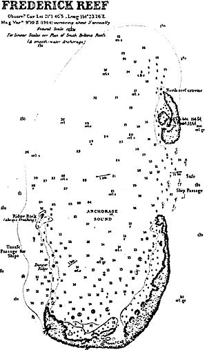
The reefs are shaped like a "J". This shape creates a protected area of water called Anchorage Sound. This sound has an opening on its northern side. The entire reef system is about 10 kilometers long and 4 kilometers wide. The water around the reef is very deep, dropping sharply to over 2,500 meters (8,200 feet) on the western side.
Contents
About Frederick Reef
The Frederick Reefs are a small, faraway group of reefs. They are found beyond the southern part of the Great Barrier Reef.
This reef system is about 540 kilometers (336 miles) east of Mackay, Queensland. It's also about 450 kilometers (280 miles) northeast of Gladstone. These reefs are part of the southern Coral Sea reefs. They are located in very deep ocean waters, far from the main land shelf.
Frederick Reefs are also near other reefs. They are about 175 kilometers (109 miles) east of the Swains Reefs. The Swains Reefs are part of the lower Great Barrier Reef. Frederick Reefs are also about 95 kilometers (59 miles) northeast of the Saumarez Reefs. And they are about 120 kilometers (75 miles) west of the Kenn Reefs.
The reefs form a protected body of water called Anchorage Sound. It's mostly surrounded by reef but open to the north. On the southern side of the reef is Observatory Cay. This is the only part of the reef that is always dry land. Other small sand islands might get covered by water when the tide is high. Observatory Cay is about 1.8 meters (6 feet) above sea level. Boats can sometimes land on its northern side through a channel. When there are strong winds, waves can sometimes break over this small island.
Like other sand islands, the exact spot of Observatory Cay can change. In 1983, it was reported to be about 750 meters (2,460 feet) west of where it was shown on maps. There might also be a few other small sand islands on the southern reef that stay dry at high tide.
A single leaning rock, about 1.2 meters (4 feet) tall, is on the western edge of the southern reef near Observatory Cay. It's about 2.4 kilometers (1.5 miles) west-northwest of Observatory Cay.
From Observatory Cay, the southern part of the reef stretches north and northeast for about 6.2 kilometers (3.9 miles).
Danger Ridge is a narrow ridge that connects Observatory Cay to Ridge Rock.
The North Reef Extreme is located north of Observatory Cay. It is about 3 kilometers (1.9 miles) north of the southern part of Observatory Cay reef. This part of the reef is about 2.7 kilometers (1.7 miles) long and 900 meters (3,000 feet) wide.
A small sand island is located 900 meters (3,000 feet) south of the Frederick Reef Light. The lighthouse is at the northeastern tip of the reef. This is the only part of the reef that is always above water. You can only get to the lighthouse by boat. Its light can be seen from about 20 kilometers (12 miles) away.
History of Frederick Reef
|
|
|
| Location | North Cay Frederick Reefs Coral Sea islands Australia |
|---|---|
| Coordinates | 20°56′06″S 154°24′00″E / 20.93500°S 154.40000°E |
| Year first constructed | ~ 1990 |
| Foundation | concrete base |
| Construction | metal tower |
| Tower shape | two-stage cylindrical tower with balcony and light |
| Markings / pattern | white tower |
| Height | 33 metres (108 ft) |
| Focal height | 33 metres (108 ft) |
| Range | 10 nautical miles (19 km; 12 mi) |
| Characteristic | Fl W 5s. |
| Admiralty number | K3016 |
| NGA number | 10220 |
How the Reef Was Discovered
The Frederick Reefs were first seen in 1812 by a ship named the Frederick. The ship's logbook described the reefs. It said they were shaped like a half-circle and were about 20 miles (32 km) wide.
The Shipwreck of the Royal Charlotte
On June 11, 1825, a ship called the Royal Charlotte ran aground on Frederick Reefs. The ship was carrying soldiers to India. To stop the ship from sinking quickly, its masts were cut down. The crew and soldiers were able to get to shore with water and food. Only two people lost their lives. A small group took the ship's longboat and sailed to Moreton Bay. They arrived in July, and another ship, the Amity, was sent to rescue the survivors. The remains of this shipwreck were found in January 2012.
The Grounding of the USS Tiru
On November 4, 1966, a United States submarine called USS Tiru got stuck on Frederick Reef. The submarine had left Brisbane, Australia, and was heading to the Philippines. For two days, the submarine tried to move off the reef by itself, but it couldn't. On November 6, an Australian warship, HMAS Vendetta, and a civilian tugboat arrived to help. The submarine was pulled off the reef and towed back to Brisbane for repairs. After some temporary fixes, the Tiru slowly made its way to Japan for more complete repairs.
The Grounding of the Jhansi Ki Rani
On April 23, 1986, a large cargo ship named Jhansi Ki Rani left Australia for Japan. It was carrying 74,000 tons of coal. The ship's route was planned to pass about 10 nautical miles (19 km) east of Frederick Reef.
During the voyage, heavy rain made it hard to see. At one point, an object was seen on the radar. The crew thought it was the Frederick Reefs Lighthouse, but it was actually another ship. Later, another radar signal appeared, but it was unclear and then disappeared due to the rain. The crew thought it was another ship. The captain came to the bridge to check on the ship's progress.
Soon after, the crew saw white lines ahead. These were waves breaking over the edge of the reef. The captain ordered the ship to turn sharply, but it wasn't enough. The ship ran aground about 5.7 nautical miles (10.6 km) from the lighthouse. The engines were stopped, and then put in reverse to try and pull the ship off the reef. After almost two hours, these attempts failed.
The ship was stuck for several days. It was finally pulled free on May 4. After being checked, it was towed to Singapore for repairs.
 | Percy Lavon Julian |
 | Katherine Johnson |
 | George Washington Carver |
 | Annie Easley |


