Saumarez Reefs facts for kids
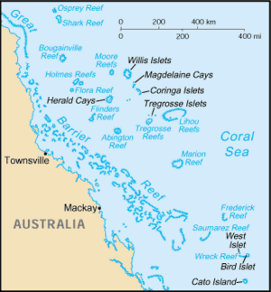
The Saumarez Reef is a group of reefs found in the Coral Sea Islands. It's one of the southernmost reefs in this area and is part of the Coral Sea Shelf. This reef system includes three main reefs and many smaller ones. Together, they form a large crescent shape that opens towards the northwest.
There are two sandy islands, called cays, within the reef: North East Cay and South West Cay.
Lieutenant John Lihou first saw these reefs on February 27, 1823, while on his ship, the Zenobia. He named them after Vice-Admiral of the United Kingdom James Saumarez, 1st Baron de Saumarez.
Contents
About Saumarez Reef
|
|
|
| Location | Northeast Cay Saumarez Reefs Coral Sea Australia |
|---|---|
| Coordinates | 21°38′13.2″S 153°45′33.0″E / 21.637000°S 153.759167°E |
| Foundation | concrete base |
| Construction | metal skeletal tower |
| Tower shape | two-stage tower, square frustum lower part, square prism upper part with balcony and light |
| Markings / pattern | white tower |
| Height | 19 metres (62 ft) |
| Focal height | 21 metres (69 ft) |
| Range | 10 nautical miles (19 km; 12 mi) |
| Characteristic | Fl (4) W 20s. |
| Admiralty number | K3015 |
| NGA number | 10300 |
The Saumarez Reef is part of the Coral Sea Shelf. It is located about 330 kilometers (205 miles) northeast of Gladstone, Queensland, in Australia. It's one of the closer coral sea islands to the mainland. The reef is only about 85 kilometers (53 miles) east of the Great Barrier Reef's Swain Reefs. It is also about 95 kilometers (59 miles) southwest of the Frederick Reefs.
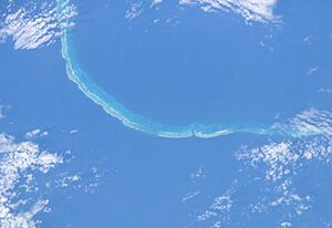
The Saumarez Reef system is made up of three main reefs and many smaller ones. They form a large crescent shape, about 39 kilometers (24 miles) wide, that opens to the northwest.
North East Cay
North East Cay (21°38′S 153°46′E / 21.633°S 153.767°E) is the northernmost sand island of the Saumarez Reefs. It's a small sandy island located near the northern end of the reefs. This cay is about 2.4 meters (8 feet) high and is surrounded by a coral reef. There is an opening on its southwestern side. A lighthouse stands on the northern edge of this cay, helping ships navigate.
South West Cay
South West Cay (21°50′S 153°30′E / 21.833°S 153.500°E) is another sand island. It is the westernmost part of the Saumarez Reefs that is above water. This cay is also about 2.4 meters (8 feet) high and is surrounded by its own reef. It is located about 10.8 kilometers (6.7 miles) northwest of an area called Southeast Elbow.
History of Discovery
On February 27, 1823, Captain John Lihou was sailing his ship, the 550-ton Zenobia, from Calcutta. He discovered the reef system and named it Sir James Saumarez' Shoal, which is now known as Saumarez Reefs. Lihou wrote down its location as "latitude 21 degrees 40 minutes, and longitude 153 degrees 46 minutes." He also thought that more reefs might exist to the northwest of this spot.
Just a few days before, on February 23, 1823, Lihou had also discovered Lihou Reef and Cays. The Zenobia was traveling from Manila to South America. Captain Lihou chose a route through Torres Strait, which was a very important decision. This was the first time a ship had sailed through Torres Strait from west to east. It was also the first time a ship had sailed through the Coral Sea from Torres Strait, heading southeast, south of New Caledonia.
In January 1823, the Zenobia entered Endeavour Strait. There, Lihou discovered a shallow port on the south coast of Prince of Wales Island. He named it Port Yarborough, which was later called Port Lihou. After a difficult journey through the Strait, where the ship lost anchors and a rudder, it left the Great Barrier Reef through an opening near the Murray Islands.
Famous Shipwrecks on the Reef
Saumarez Reef has been the site of several shipwrecks over the years. These stories remind us of the dangers of the sea.
The Noumea in May 1880
On May 13, 1880, the schooner Noumea was on its way back to Mackay from Santa Island. It was carrying ninety-nine Islanders, including eight women. The ship hit Saumarez Reef and was completely destroyed. Sadly, seven of the Islanders drowned while trying to swim from the wreck to the rescue boats. However, the rest of the Islanders and the ship's crew were saved by the steamer Leichhardt. This rescue ship was sent by the owner of the Noumea.
The Noumea was a vessel of about 144 tons, roughly 100 feet long. It was built in 1873. The ship's captain, R.J. Belbin, had a lot of experience in the South Sea Island labor trade.
Captain South of another ship, the Keilawarra, reported picking up Captain Belbin and six white sailors in a boat. They were in great distress after the Noumea had been wrecked. Captain South also reported that four white men and ninety-nine Islanders were still at the wreck, needing help and food.
The owner of the Noumea quickly arranged for the steamer Leichhardt to go to the wreck. The Leichhardt arrived at Keppel Bay on May 21, 1880. It brought all the European crew and ninety-three South Sea Islanders to safety. Some of the rescued Islanders were very weak, but thankfully, no one was sick. The Islanders then continued their journey to Mackay on another ship called the Tinonee.
The Noumea was badly damaged and lost its masts. It became a total wreck on the northeast point of Saumarez Reef. One of the crew members, Arthur William Munson, shared his story. He said the ship struck the reef not too hard at first, but then bounced high onto it. He described how people tried to get to the boats and how some were lost in the water. He also mentioned that those left on the wreck had only salt-water damaged bread to eat.
The SS Francis Preston Blair in July 1945
The SS Francis Preston Blair was an American Liberty ship, weighing 7196 tons. It was built in 1943. This ship was wrecked on the eastern edge of the Saumarez Reef on July 15, 1945. The stranding happened during a cyclone. Interestingly, the Royal Australian Air Force (RAAF) sometimes used the wreck for target practice in the 1980s, dropping practice and live bombs. There was also an unexplained explosion hole in the front of the ship at the waterline.
 | Victor J. Glover |
 | Yvonne Cagle |
 | Jeanette Epps |
 | Bernard A. Harris Jr. |


