Freeport Main Street Historic District facts for kids
Quick facts for kids |
|
|
Freeport Main Street Historic District
|
|

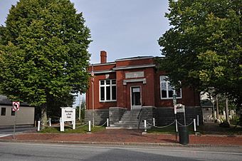
The former B. H. Bartol Library, housing an Abercrombie and Fitch outlet in 2014
|
|
| Lua error in Module:Location_map at line 420: attempt to index field 'wikibase' (a nil value). | |
| Location | Main St., Freeport, Maine |
|---|---|
| Area | 3.5 acres (1.4 ha) |
| Architectural style | Colonial Revival, Federal, Shingle Style |
| NRHP reference No. | 77000064 |
| Added to NRHP | November 16, 1977 |
Imagine stepping back in time! The Freeport Main Street Historic District is a special part of Freeport, Maine. It's a small area on Main Street, also known as U.S. Route 1. This district was added to the National Register of Historic Places in 1977. It protects many old buildings from the 1800s. These buildings show us what Freeport looked like long ago.
Contents
Exploring Freeport's Historic Buildings
This historic district has nine main buildings. Most of them were homes in the 1800s. Today, many of these old houses are shops. But they still look very much like they did back then.
Oldest Homes and Special Styles
The oldest building here is the Mitchell-Soule-Davis House. It was built around 1790. This house is a "Federal Cape" style. Another cool house is the Harrington House, built around 1830. It's made of brick and shows a mix of "Federal" and "Greek Revival" styles. Today, it's home to the Freeport Historical Society. The newest building in the district is the Gould House, built in 1922. It has a "Colonial Revival" style.
Important Public Buildings
There are also two important public buildings in the district. The Congregational Church was built in 1895. It has a unique "Shingle style" design. The old B. H. Bartol Library is another key building. It was built with help from Andrew Carnegie, a famous businessman. Like many other buildings, it is now used as a store.
A Look at Freeport's Past
The Main Street area became important later than other parts of Freeport. Earlier centers like Mast Landing were closer to the Harraseeket River. These older areas are now part of the Harraseeket Historic District.
How Main Street Grew
By the late 1700s, Main Street started to become busy. It was a stop for stagecoaches traveling between Portland and Brunswick. Later, in the 1800s, factories and businesses grew in Freeport. This made Main Street the main center of town.

