
Freeport, Maine facts for kids
Quick facts for kids
Freeport, Maine
|
||
|---|---|---|

View of downtown
|
||
|
||
| Nickname(s):
The Birthplace of Maine
|
||

Location in Cumberland County and the state of Maine.
|
||
| Country | ||
| State | ||
| County | Cumberland | |
| Incorporated | February 14, 1789 | |
| Communities |
|
|
| Area | ||
| • Total | 46.47 sq mi (120.36 km2) | |
| • Land | 34.70 sq mi (89.87 km2) | |
| • Water | 11.77 sq mi (30.48 km2) | |
| Elevation | 36 ft (11 m) | |
| Population
(2020)
|
||
| • Total | 8,737 | |
| • Density | 252/sq mi (97.2/km2) | |
| Time zone | UTC−5 (Eastern (EST)) | |
| • Summer (DST) | UTC−4 (EDT) | |
| ZIP Codes |
04032–04034
|
|
| Area code(s) | 207 | |
| FIPS code | 23-26525 | |
| GNIS feature ID | 0582481 | |

Freeport is a town in Cumberland County, Maine, United States. It is known for its many outlet stores. Freeport is also home to the famous outdoor gear company L.L. Bean. Other popular spots include Wolfe's Neck Woods State Park and the unique Desert of Maine. In 2020, about 8,737 people lived in Freeport.
History of Freeport
Freeport was once part of a larger town called North Yarmouth. This area was known as Harraseeket, named after the Harraseeket River. People first settled here around the year 1700.
Early Days and Name
Freeport officially became its own town on February 14, 1789. It is likely named "Freeport" because its harbor was often "free from ice." This made it easy for ships to come and go.
Freeport grew into four main villages:
- Mast Landing
- Porter's Landing
- South Freeport
- Freeport Corner
These villages are now part of the Harraseeket Historic District. This district is a special place listed on the National Register of Historic Places.
Life in the Villages
At Mast Landing, people shipped timber for building, especially for tall ship masts. A dam was built on the river to power mills. These mills helped grind grain and cut wood.
Porter's Landing was important for shipbuilding after the American Revolutionary War. This industry was busiest between 1850 and 1860. But it slowed down during the American Civil War.
South Freeport was the biggest village by the water. It once had four shipyards. People also worked in fishing, canning, and farming. In 1903, a hotel called Casco Castle was built here. It was meant to encourage people to travel by trolley. The hotel burned down in 1914, but its tower still stands today.
Freeport Corner was an inland village. It was a center for farming and trade. When the railroad arrived in 1849, it helped this area grow. It became the main shopping and business center of the town. In the 1800s, fabric was sent here from big cities. Local workers would sew it into clothes. A businessman named E. B. Mallet had a sawmill, a brickyard, a granite quarry, and a large shoe factory in Freeport.
The L.L. Bean Story
In 1912, Leon Leonwood Bean opened a small store in Freeport. It was in the basement of his brother's clothing shop. He sold his famous "Bean Boot" (also called the Maine Hunting Shoe).
His store, L. L. Bean, became very popular. By 1951, it started staying open 24 hours a day, every day! L.L. Bean grew into a huge company. It sells outdoor gear all over the world.
The main L.L. Bean store is a big draw for shoppers. It helps make Freeport a popular place for outlet shopping. About 3.5 million people visit Freeport every year. L.L. Bean also hosts fun events. These include their Outdoor Discovery Schools. They also have a Summer Concert Series. Famous artists like Rockapella have performed there.
The McDonald's House
In 1982, McDonald's wanted to build a restaurant in Freeport. They planned to tear down an old house from the 1850s. This house was called the Gore House.
But the people of Freeport spoke up. They wanted to save the old house. So, the town made new rules. These rules said what businesses could do with their buildings. McDonald's had to build their restaurant inside the old house. It opened in 1984. The outside of the house looked almost the same. This was one of the first times McDonald's changed its design. It showed how important local history was to the town.
-
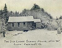
Old Ledge Schoolhouse c. 1905
-
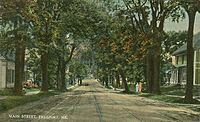
Main Street c. 1910
-
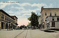
Main Street c. 1912
-
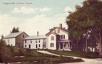
Jameson Tavern c. 1915
-
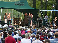
Rockapella performs at the L.L. Bean Summer Concert Series, July 2003
-
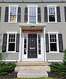
The McDonald's in Freeport. It was built inside an old house.
-

Main Street in 2012.


Geography and Climate
Freeport covers about 46.47 square miles (120.36 square kilometers). Most of this area is land, but about 11.77 square miles (30.48 square kilometers) is water. The town is located at the end of Casco Bay. The Harraseeket River flows through Freeport.
Neighboring Towns
Freeport shares borders with several other towns. These include Brunswick and Durham to the north. To the west are Pownal and Yarmouth. Freeport's border also extends into Casco Bay. This means it touches parts of Cumberland and Harpswell by water.
Weather in Freeport
Freeport has a climate with big changes in temperature. Summers are warm and often humid. Winters are cold, sometimes very cold. This type of weather is called a warm-summer humid continental climate.
Getting Around Freeport
It is easy to get to and from Freeport. Both U.S. Route 1 and Interstate-295 go right through the town.
Train and Bus Service
You can take the Amtrak Downeaster train to Freeport. The train stops at Freeport station. From there, you can go to Portland Transportation Center or Boston.
The Greater Portland Metro also has a bus service called BREEZ. This bus connects Brunswick and Portland. It makes four stops in Freeport.
Population Information
Freeport has grown steadily over the years. In 1790, about 1,320 people lived here. By 2020, the population had grown to 8,737 people.
People in Freeport (2010)
In 2010, there were 7,879 people living in Freeport. There were 3,209 households. Most people (95.2%) were White. About 2.3% were Asian, and 0.6% were African American.
Many households (32.6%) had children under 18. Most families (55.8%) were married couples. The average age in town was 45 years old. About 22.8% of residents were under 18.
Education
Freeport is part of Regional school unit #5. This means it shares school services with other towns.
Public Schools
- Morse Street School, for grades K–2
- Mast Landing School, for grades 3–5
- Freeport Middle School, for grades 6–8
- Freeport High School, for grades 9–12
Private Schools
Freeport also has several private schools:
- École Française du Maine, which teaches in French for grades K–7
- Maine Coast Waldorf School
- Pine Tree Academy, a school run by the Seventh-day Adventist Church
Fun Places to Visit
Freeport has many interesting places to explore:
- Desert of Maine: A unique sandy area that looks like a desert.
- Wolfe's Neck Woods State Park: A beautiful park with trails and ocean views.
- Wolfe’s Neck Center for Agriculture & the Environment: A farm and education center.
Famous People from Freeport
Many notable people have lived in Freeport:
- Joan Benoit Samuelson: An Olympic gold medalist in the marathon (1984).
- Donald B. MacMillan: An admiral and Arctic explorer.
- Sara Gideon: A former Speaker of the Maine House of Representatives.
- John Gould: A well-known humorist and columnist.
- Aaron Lufkin Dennison: A famous watchmaker.
See also
 In Spanish: Freeport (Maine) para niños
