
Yarmouth, Maine facts for kids
Quick facts for kids
Yarmouth, Maine
|
||
|---|---|---|

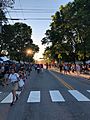
Yarmouth's Main Street during its annual Clam Festival
|
||
|
||
| Motto(s):
Our Latchstring Always Out
|
||

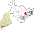
Location in Cumberland County and the state of Maine
|
||
| Country | United States | |
| State | Maine | |
| County | Cumberland | |
| Settled | 1636 | |
| Incorporated | August 8, 1849 | |
| Villages |
|
|
| Area | ||
| • Total | 22.94 sq mi (59.41 km2) | |
| • Land | 13.35 sq mi (34.58 km2) | |
| • Water | 9.59 sq mi (24.84 km2) | |
| Elevation | 43 ft (13 m) | |
| Population
(2020)
|
||
| • Total | 8,990 | |
| • Density | 673/sq mi (260.0/km2) | |
| Time zone | UTC-5 (Eastern (EST)) | |
| • Summer (DST) | UTC-4 (EDT) | |
| ZIP code |
04096
|
|
| Area code(s) | 207 | |
| FIPS code | 23-87845 | |
| GNIS feature ID | 0582831 | |
| Website | yarmouth.me.us | |

Yarmouth is a town in Cumberland County, Maine, United States. It is located about twelve miles north of Portland, Maine's largest city.
The town was first settled in 1636 and was called North Yarmouth. At that time, it was part of the Massachusetts Bay Colony. In 1849, Yarmouth officially became its own town.
Yarmouth is part of the larger Portland–South Portland–Biddeford Metropolitan Area. In 2020, the town had a population of 8,990 people.
Because Yarmouth is close to the Atlantic Ocean and sits on the Royal River, it was a great spot for a harbor. Many ships were built here between 1818 and the 1870s. The Royal River also has four waterfalls. These waterfalls provided power for almost sixty mills that operated between 1674 and 1931.
Every year, Yarmouth hosts the Yarmouth Clam Festival. This popular event brings in about 80,000 visitors, which is about ten times the town's population!
Contents
Geography and Nature
Yarmouth covers a total area of about 22.94 square miles (59.41 km2). About 58% of this area is land, and 42% is water.
The Royal River flows right through the middle of Yarmouth. The town is bordered by Freeport to the north and Cumberland to the west. To the south, it meets Casco Bay. Yarmouth also includes several islands, such as Cousins Island and Littlejohn Island.
The Royal River was very important to early settlers because its waterfalls offered waterpower. In 1674, the first sawmill was built on the river. However, it was abandoned two years later due to conflicts with Native Americans.
Yarmouth has four main waterfalls on the Royal River. The First Falls are less than a mile from the river's mouth. The Sparhawk Mill, one of the town's old mill buildings, is located near the Second Falls. The Third Falls, also known as Baker Falls, were the busiest. The Forest Paper Company, once the world's largest pulp and paper mill, operated there from 1874 to 1923. The Fourth Falls are further upstream.
Over the years, 57 different mills and several factories have used the river's power. They produced things like grain, lumber, paper, shoes, and bricks.
Yarmouth's coastline has two main coves: White's Cove and Broad Cove.
Population and People
| Historical population | |||
|---|---|---|---|
| Census | Pop. | %± | |
| 1850 | 2,144 | — | |
| 1860 | 2,027 | −5.5% | |
| 1870 | 1,872 | −7.6% | |
| 1880 | 2,021 | 8.0% | |
| 1890 | 2,098 | 3.8% | |
| 1900 | 2,274 | 8.4% | |
| 1910 | 2,358 | 3.7% | |
| 1920 | 2,216 | −6.0% | |
| 1930 | 2,125 | −4.1% | |
| 1940 | 2,214 | 4.2% | |
| 1950 | 2,669 | 20.6% | |
| 1960 | 3,517 | 31.8% | |
| 1970 | 4,854 | 38.0% | |
| 1980 | 6,585 | 35.7% | |
| 1990 | 7,862 | 19.4% | |
| 2000 | 8,360 | 6.3% | |
| 2010 | 8,349 | −0.1% | |
| 2020 | 8,990 | 7.7% | |
| U.S. Decennial Census Raymond H. Fogler Library 2012 Estimate |
|||
2010 Census Snapshot
In 2010, Yarmouth had 8,349 people living in 3,522 households. The town's population density was about 625.4 inhabitants per square mile (241.5/km2). This made Yarmouth one of the more densely populated towns in the area, after Portland, South Portland, and Westbrook.
Most residents were White (96.9%). About 30% of households had children under 18 living with them. The average age in Yarmouth was 45.9 years old. About 22.8% of residents were under 18, and 16.7% were 65 or older.
History of Yarmouth

The area now known as Yarmouth was originally called Westcustogo by Native Americans. English settlers arrived in 1636. One of the first European settlers was William Royall, who bought a farm in 1636. The Royal River is named after him.
Another early settler, George Felt, bought land at Broad Cove in 1643. In 1652, John Cousins sold land that became known as Maine's Point.
In 1675, conflicts began between the local Native Americans and the settlers. This was part of a larger conflict called King Philip's War. Settlers had to leave their homes and move south. This unrest continued for many years.
Around 1715, a more permanent settlement began in Yarmouth. By 1764, 1,098 people lived in 154 houses. The town's Main Street slowly grew into two areas: the Upper Village and Lower Falls.
The Town of Yarmouth officially became a town on August 8, 1849.
Shipbuilding History
Maritime activities, like shipbuilding, were very important to Yarmouth from its early days. Between 1790 and 1890, almost 300 ships were built and launched from Yarmouth's shipyards.
Historic Places

Twelve buildings and places in Yarmouth are listed on the National Register of Historic Places. This means they are important historical sites. The oldest is the Cushing and Hannah Prince House, built in 1785. The newest is the Grand Trunk Railway Station, built in 1906.
Some of these historic places include:
- Cushing and Hannah Prince House, 189 Greely Road
- North Yarmouth and Freeport Baptist Meeting House, 3 Hillside Street
- Ammi Mitchell House, 333 Main Street
- Russell Hall, North Yarmouth Academy, 141 Main Street
- Academy Hall, North Yarmouth Academy, 129 Main Street
- Capt. S. C. Blanchard House, 317 Main Street
- Captain Reuben Merrill House, 233 West Main Street
- First Universalist Church, 97 Main Street
- First Parish Congregational Church, 116 Main Street
- Camp Hammond, 275 Main Street
- Cousins Island Chapel, 414 Cousins Street
- Grand Trunk Railway Station, 288 Main Street
Economy and Businesses

Yarmouth was once home to DeLorme, a large map-making company. Their headquarters had Eartha, the world's largest revolving and rotating globe. In 2016, DeLorme was bought by Garmin.

The Wyman Power Station, which uses oil to make electricity, is located on Cousins Island. It is part of Central Maine Power (CMP).
Yarmouth does not have any hotels or motels anymore. The last one, the Down-East Village Restaurant & Motel, was taken down in 2017. It was one of the oldest motels in Maine.
A drive-in movie theater used to be where the Hannaford grocery store plaza is now.
In 2019, the town started a plan to improve Main Street. Work began in 2021 to make the street better for walking and shopping.
Education in Yarmouth

Yarmouth has four public schools:
- William H. Rowe (Elementary) School (for kindergarten and first grade)
- Yarmouth Elementary School (for second through fourth graders)
- Frank H. Harrison Middle School
- Yarmouth High School
Three of these schools are close to each other. Rowe School is about two miles away. Yarmouth High School has been recognized as one of the best high schools in Maine and the country.
North Yarmouth Academy (NYA) is a private school in Yarmouth. It was founded in 1814. NYA became a private school in 1961 when the new Yarmouth High School was built. The academy's ice arena is named after Travis Roy, a former student who was injured while playing hockey.
Transportation Around Town
Roads and Highways

In 1727, local leaders started planning roads for the new town. Early roads included today's Pleasant Street and Atlantic Highway.
In 1761, Benjamin Franklin, who was then Postmaster General, ordered milestones to be placed along the King's Highway. This route connected Boston to northern locations like Machias, Maine. Yarmouth has three of these historic milestones.


In 1813, a new road was built near the First Falls, which is now Lafayette Street. It was named after General Lafayette, a French hero who stayed in a building on East Main Street.
State Route 115, which is Yarmouth's Main Street, was officially named in 1925. U.S. Route 1 came through Yarmouth in the late 1940s.
In 1961, Interstate 295 was built through Yarmouth. It has two exits in town (Exits 15 and 17).
Trains and Trolleys

Yarmouth has two railroad junctions: Royal Junction and Yarmouth Junction. The Guilford Rail System (Kennebec & Portland) and the now unused St. Lawrence and Atlantic Railroad pass through town.
In 2012, the Downeaster passenger train service was extended to Brunswick, Maine. These trains now pass through Yarmouth several times a day.
From 1898 to 1933, Trolley cars from the Portland and Yarmouth Electric Railway Company ran through Yarmouth. They traveled from Portland, through Falmouth, and onto Pleasant Street and Main Street.
Bus Service
The only bus route serving Yarmouth is Greater Portland Metro's BREEZ. It runs between Portland and Brunswick on weekdays and Saturdays. There are three bus stops in Yarmouth: at the I-295 park and ride, in front of Yarmouth Town Hall, and on Route 1 at Hannaford.
Fun and Recreation
Parks to Explore

Yarmouth has several parks where you can relax and play:
- Grist Mill Park, East Main Street
- Village Green Park, Main Street
- Latchstring Park, Main Street and West Elm Street
- Royal River Park, between East Elm Street and Bridge Street
- Pratt's Brook Park, North Road

Nature Preserves and Trails
The town also has many open spaces and conservation lands for enjoying nature:
- Spear Farm Estuary Preserve, Bayview Street
- Fels-Groves Farm Preserve, Gilman Road
- Larrabee's Landing, Burbank Lane
- Frank Knight Forest, East Main Street
- Cousins River Fields and Marsh Project, Granite Street
- Barker Preserve, between East Elm Street and Royal River
- Riverfront Woods Preserve, River Front Drive
- Camp SOCI, Sandy Point Road, Cousins Island (a camp established in 1957)
- Sandy Point Beach, Cousins Street, Cousins Island
- Katherine Tinker Preserve, Seal Lane, Cousins Island
- Littlejohn Island Preserve, Pemasong Lane, Littlejohn Island
You can also find trails like the West Side Trail and Spears Hill Trail for walking and exploring.
Beth Condon Memorial Pathway
This is a special recreation path that starts near the intersection of Portland Street and Route 1. It's a great place for walking and biking.
Churches and Cemeteries
Churches in Yarmouth

Yarmouth has eight churches. Four of them are located on Main Street:
- First Universalist, 97 Main Street (built 1860)
- First Parish Congregational, 116 Main Street (built 1867)
- Sacred Heart Catholic Church, 326 Main Street (built 1929)
- First Baptist Church, 346 Main Street (built 1889)
The North Yarmouth and Freeport Baptist Meeting House on Hillside Street was built in 1796. It was used as a church until 1889, then became the town's first library. During World War II, its belfry was used by volunteers to spot airplanes.
Other churches include St. Bartholomew's Episcopal on Gilman Road, Royal River Baptist Church on Route One, and Cousins Island Chapel (1895).
Cemeteries and Burial Grounds

Yarmouth has several cemeteries. The Old Baptist Cemetery is next to the Meeting House on Hillside Street.
Near the old "Old Ledge" Meeting House on Lafayette Street, you'll find the Pioneer Cemetery (1731) and the Ledge Cemetery (1770). Many early settlers are buried here.
Riverside Cemetery (founded 1869) and Holy Cross Cemetery are next to each other on Smith Street. Many important townspeople are buried in Riverside Cemetery, including Leon Gorman, the former president of L.L.Bean.
Other cemeteries include Davis Cemetery on Granite Street and Cousins Island Cemetery.
Local News and Media
An early newspaper in Yarmouth was the Eastern Gazette, first printed in 1886. Later, the town had its own page, the Yarmouth Gazette, in the Six Towns Times newspaper (1892-1916).
Today, Yarmouth news is reported in newspapers like the Portland Press Herald and The Forecaster. The local newspaper The Notes was published from 1953 to 2021.
Yarmouth is also home to one radio station, WYAR, which started broadcasting from Cousins Island in 1998.
Yarmouth Clam Festival

The Yarmouth Clam Festival is a big annual event that started in 1965. It happens every year during the third weekend in July and attracts about 120,000 people. The festival includes a parade, lots of food (especially clams!), carnival rides, crafts, a clam-shucking contest, a five-mile run, and a bike race.
"Herbie" the Elm Tree
"Herbie" was a famous elm tree that stood on East Main Street (Route 88) from 1793 to 2010. It was 110 feet tall and, for many years, was the oldest and largest elm tree in New England.
Sadly, Herbie got Dutch elm disease and had to be removed in 2010. Frank Knight, who took care of Herbie for over fifty years, passed away in 2012 at 103 years old. The Frank Knight Forest on East Main Street is named in his honor.
Notable People from Yarmouth
Many interesting people have lived in Yarmouth throughout its history.
- Early Settlers of Westcustogo
- John Cousins, English settler
- George Felt, English settler
- William Royall, English settler
- People from North Yarmouth (before 1849)

- Rufus Anderson, a minister
- Peter Chardon Brooks, a Massachusetts state senator
- Augustus W. Corliss, a writer and historian
- Levi Cutter, who became the fourth Mayor of Portland
- Elizabeth Oakes Smith, a writer
- Edward Russell, a politician and brigadier general
- People from Yarmouth, Maine (after 1849)

- F. Lee Bailey, a famous lawyer
- Leon Gorman, former president of L.L.Bean
- William Hutchinson Rowe, a historian and author
- Oliver Wahlstrom, an NHL hockey player
- Eric Weinrich, a former NHL defenseman
Images for kids
-
Yarmouth's Main Street during its annual Clam Festival
-
Seal of Yarmouth, Maine
-
Location in Cumberland County and the state of Maine
-
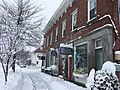
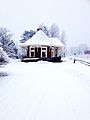
Yarmouth's Upper Village in 2017
-
Grand Trunk Railway Station (1906), now occupied by a savings bank
-
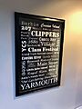
A Yarmouth-themed poster on display at the town's Merrill Memorial Library in 2018
-
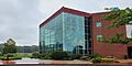
Garmin houses Eartha, the largest rotating globe
-
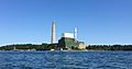
Wyman Power Station in 2016
-
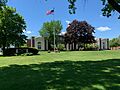
North Yarmouth Academy. The main building is flanked by Safford Auditorium (left) and Cutter Gymnasium (right)
-
A milestone on the Boston-to-Machias "King's Highway" route. The milestone, now incorporated into a wall, is engraved with "B 138," to denote its distance of 138 miles from Boston. It is located on Pleasant Street
-
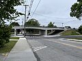
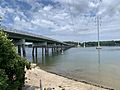
Looking west toward Main Street's Route 1 overpass and Brickyard Hollow in August 2019. This bridge was rebuilt between late 2017 and August 2019, replacing a structure from the 1950s
-
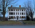
General Lafayette once stayed in the three-storey building at 51 East Main Street, erected in 1810
-
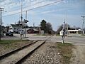
Yarmouth Crossing, where Main Street traverses the St. Lawrence and Atlantic Railroad, looking north from Railroad Square
-
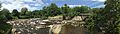
Grist Mill Park, viewed from the bottom of the Main Street hill at the First Falls
-
Sandy Point Beach at high tide, looking back to the mainland
-
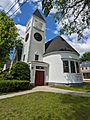
First Baptist Church
-
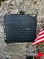
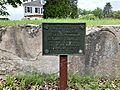
Pioneers burial ground marker. It was removed to the town's historical society in February 2019, after being in place for 90 years, because some people found the word "savage" offensive
-
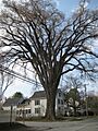
"Herbie" stood on present-day East Main Street (State Route 88) at its intersection with Yankee Drive. This photograph taken prior to its spread being reduced in 2008. The tree succumbed to Dutch elm disease and was removed in January 2010
-
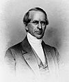
Rufus Anderson, minister (1796–1880)
-

F. Lee Bailey (1933–2021)

See also
 In Spanish: Yarmouth (Maine) para niños
