History of Yarmouth, Maine facts for kids
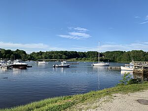
The town of Yarmouth, Maine, has a history closely connected to the Royal River and Casco Bay. This area was first settled by Native Americans. Later, European settlers arrived, and there were several conflicts before the Native Americans left the area in the mid-1700s.
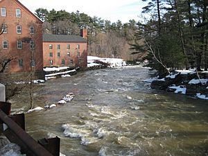
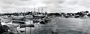
From about 1790 to 1890, around 300 ocean-going ships were built in the many shipyards in Yarmouth harbor. Also, nearly 60 mills were built along the Royal River over 250 years, using the power from its four waterfalls. Many of Yarmouth's old buildings are considered important enough to be listed on the National Register of Historic Places, and twelve are already included.
Contents
First People and European Settlers
People have lived in the Yarmouth area for a very long time, possibly as far back as 2,000 BC. Before Europeans arrived, many Native American groups lived here. They used the natural features of the coast, especially the rivers, for food, good soil for farming, power for mills, and travel between the land and the ocean.
In 1643, an Englishman named George Felt bought 300 acres of land at Broad Cove. He had moved to America 18 years earlier. This made him one of the first European settlers in Yarmouth.
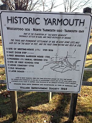
Another early settler was William Royall, a barrel maker. He came to America in 1629. In 1636, he bought a farm at what is now Lambert Point. He lived there with his wife, Phoebe Green, and they had 13 children. The Royal River is named after him, though with a slightly different spelling. The Native Americans called this river and the nearby area "Westcustogo."
John Cousins arrived even earlier than Royall. He settled with his wife, Mary, on the land between the branches of the Cousins River and Cousins Island.
By 1676, about 65 people lived in Westcustogo. However, conflicts like King Philip's War (1675–1678) forced them to leave their homes and move south. John Cousins was hurt and died in 1682.
Some settlers returned in 1679. Within a year, the area became known as North Yarmouth, the eighth town in the Province of Maine.
In 1688, during King William's War, settlers building a fort were attacked by Native Americans. They fought back, but the Native Americans returned with more force. The 36 families living there had to leave their homes again. Walter Gendall, who had been friendly with the Native Americans, was killed.
The area was empty for many years after this. By 1715, settlers came back and found their fields covered with young trees. The mills at the First Falls were rebuilt first. In 1722, a group was formed in Boston to help resettle North Yarmouth.
In 1725, William and Matthew Scales were killed by Native Americans. William's wife and daughter, both named Susannah, survived. His daughter later married James Buxton, and they are buried in the Ledge Cemetery.
Joseph Felt, another settler, also died. His wife, Sarah, and their children were captured for five years. Sarah was later rescued by Captain Peter Weare.
Once resettlement began in 1727, the town's population grew quickly. A map was made, dividing the land into 10-acre lots for 103 original settlers. If a settler built on and improved their lot, they could apply for more land.
The first meetinghouse, the Meetinghouse under the Ledge, was built in 1729 on what is now Gilman Road. Nine years later, the first school was built. North Yarmouth held its first town meeting on May 14, 1733.
In 1756, Native Americans attacked and killed members of the Means family at Flying Point. This was the last time Native Americans resisted within the town's borders.
By 1764, 1,098 people lived in 154 houses. By 1810, the population was 3,295. During a time of peace, people started settling more along the coast and inland.
The town's Main Street slowly divided into the Upper Village and Lower Falls. This split was roughly where the U.S. Route 1 overpass is today.
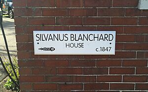
The Yarmouth Village Improvement Society has placed wooden plaques on over 100 important buildings in town. Some examples include:
- Cushing and Hannah Prince House, built in 1785.
- Mitchell House, built around 1800, home to three doctors.
- Capt. S. C. Blanchard House, built in 1855 by a successful shipbuilder, Sylvanus Blanchard.
- Captain Rueben Merrill House, built in 1858 for a well-known sea captain.
Another important building is Camp Hammond (1889–90). It was built in a special way to prevent fires, using heavy planks over timbers. Frederick Law Olmsted, who designed New York's Central Park, planned the outdoor areas for Camp Hammond.
In 1822, a "grasshopper plague" caused the loss of wheat and corn crops. Around 1847, the Old Ledge School was moved. A replica now stands on West Main Street.
Becoming an Independent Town
Yarmouth was part of North Yarmouth until 1849. On August 8 of that year, it became its own independent town. The split happened because of disagreements between the farming community inland and the coastal community focused on the sea. They couldn't agree, so the two parts separated into today's Yarmouth and North Yarmouth.
In 1849, Yarmouth had nine districts. By 1874, people tried to change this system because they felt it was unfair in how money was shared.
By 1850, Yarmouth's population was 2,144, and it didn't change much for the next 100 years. Businesses in the 18th and 19th centuries relied on natural resources. After lumber was cut, the land was farmed. Tanneries (places that make leather) were built near streams. Potteries and brickyards used the natural clay, and mills along the Royal River helped with things like shaping iron and finishing cloth.
Shipbuilding in Yarmouth
Maritime activities, meaning things related to the sea, were very important from the start of the third settlement. Yarmouth's shipyards launched almost 300 ships between 1790 and 1890.
Yarmouth in the Late 1800s
In 1887, a fire started in dry grass near the Grand Trunk Station, likely from a spark from a train. A strong wind spread the fire quickly, burning 200 acres. The fire only stopped when it reached the waters of Broad Cove.
Yarmouth's "town system" began in April 1889. Three of the old districts were closed because they were small and had old buildings.
Electricity came to Yarmouth in 1893.
Entering the 1900s
Another big fire happened in April 1900. A corn-canning factory caught fire from a spark from a sawmill. A strong wind carried sparks across the most populated part of town, causing small fires in many places. More than 20 buildings were burning at the same time.
In 1903, the post office started a route for rural free mail delivery around town. Joshua Adams Drinkwater became the town's first letter carrier. He would pick up mail and deliver it to different parts of town, changing horses and eating lunch at his farm.
In 1918, the Spanish flu affected the town in two waves, leading to 370 infections and 14 deaths.
In 1923, town historian William Hutchinson Rowe announced he was writing a history of Yarmouth. The book took 14 more years to finish but was so detailed that it is still available today.
A Grippe (flu) epidemic hit the town in January 1944, and 2,000 residents were placed in quarantine.
In 1949, Yarmouth celebrated its 100th birthday with a parade.
The town grew quickly again after 1948 when Route 1 was built through it. Two years later, the town had 2,699 residents. Interstate 295 was built through the harbor in 1961. Yarmouth's population grew about 40% from 1970 to 2005, from 4,854 to 8,300 residents.
Yarmouth Today
In the early 21st century, Yarmouth is mostly a residential town, meaning many people live there. There are also businesses spread throughout the town, especially along Route 1 and Main Street (State Route 115).
See also
- Historical buildings and structures of Yarmouth, Maine
 | Jackie Robinson |
 | Jack Johnson |
 | Althea Gibson |
 | Arthur Ashe |
 | Muhammad Ali |


