
French Camp, Mississippi facts for kids
Quick facts for kids
French Camp, Mississippi
|
||
|---|---|---|

French Camp Academy
|
||
|
||

Location of French Camp, Mississippi
|
||
| Country | United States | |
| State | Mississippi | |
| County | Choctaw | |
| Government | ||
| Area | ||
| • Total | 0.99 sq mi (2.56 km2) | |
| • Land | 0.98 sq mi (2.54 km2) | |
| • Water | 0.01 sq mi (0.02 km2) | |
| Elevation | 413 ft (126 m) | |
| Population
(2020)
|
||
| • Total | 256 | |
| • Density | 260.96/sq mi (100.76/km2) | |
| Time zone | UTC-6 (Central (CST)) | |
| • Summer (DST) | UTC-5 (CDT) | |
| ZIP code |
39745
|
|
| Area code(s) | 662 | |
| FIPS code | 28-26020 | |
| GNIS feature ID | 0670200 | |

French Camp is a small town in Choctaw County, Mississippi, in the United States. It is known for its history and a special school called French Camp Academy. In 2020, about 256 people lived there. The population was 174 at the 2010 census.
Contents
A Look Back in Time: French Camp's History
French Camp started around 1810. A French person named Louis Lefleur set up a trading post and an inn here. It was located on the famous Natchez Trace, a historic path.
The local Choctaw people and others called this place "the Frenchman's Camp." Over time, the name was shortened to French Camp.
Where is French Camp? Geography and Location
French Camp is in the western part of Choctaw County. It is right next to Attala County to the south.
The Natchez Trace Parkway goes right through the town. It crosses Mississippi Highway 413 just west of the town center.
Land and Water Area
The United States Census Bureau says the town covers about 2.6 square kilometers (1.0 square mile). Most of this area is land. Only a tiny part, about 0.02 square kilometers (0.01 square miles), is water.
Who Lives Here? French Camp's Population
| Historical population | |||
|---|---|---|---|
| Census | Pop. | %± | |
| 1880 | 420 | — | |
| 1890 | 267 | −36.4% | |
| 1900 | 259 | −3.0% | |
| 1910 | 220 | −15.1% | |
| 1920 | 123 | −44.1% | |
| 1930 | 181 | 47.2% | |
| 1940 | 172 | −5.0% | |
| 1950 | 162 | −5.8% | |
| 1960 | 123 | −24.1% | |
| 1970 | 174 | 41.5% | |
| 1980 | 306 | 75.9% | |
| 1990 | 320 | 4.6% | |
| 2000 | 393 | 22.8% | |
| 2010 | 174 | −55.7% | |
| 2020 | 256 | 47.1% | |
| U.S. Decennial Census | |||
In 2000, there were 393 people living in French Camp. These people lived in 68 households, and 42 of these were families. The town had about 74 housing units.
Most of the people living in French Camp were White (92.37%). A smaller number were African American (5.09%) or from other backgrounds.
Household and Family Life
About 26.5% of households had children under 18 living with them. Many households (54.4%) were married couples. Some households (36.8%) were individuals living alone.
The average household had 2.43 people. The average family had 3.19 people.
Age of Residents
The population in French Camp was quite young. About 48.6% of residents were under 18 years old. The median age was 18 years. This means half the people were younger than 18, and half were older.
Learning in French Camp: Schools and Education
Students in French Camp attend schools run by the Choctaw County School District. There is also a special private school in town.
- French Camp Elementary School
- This school is part of the Choctaw County School District. It serves younger students in French Camp.
- French Camp Academy
- French Camp Academy is a Christian boarding school. Students live at the school while they study.
Cool Places to Visit: Points of Interest
French Camp has several interesting places to see and visit:
- Rainwater Observatory and Planetarium: A place to learn about stars and space.
- French Camp Town Hall: This building also houses the town's volunteer fire department.
- French Camp Academy Campus: You can see the grounds of this historic school.
- Natchez Trace Historic Village: This area includes:
- Council House Cafe: A place to eat.
- WFCA (FM): A local radio station.
Images for kids
-
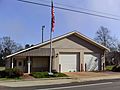
French Camp Town Hall
-

French Camp Elementary School
-

French Camp Post Office
-
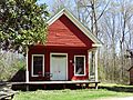
Old French Camp Post Office


See also
 In Spanish: French Camp (Misisipi) para niños
