French Island (California) facts for kids

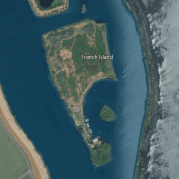
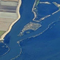
USGS aerial imagery of French Island; Hastings Tract is across Cache Slough to the west, and the flooded Liberty Island is across Shag Slough to the east.
|
|
| Geography | |
|---|---|
| Location | Northern California |
| Coordinates | 38°15′51″N 121°41′38″W / 38.26417°N 121.69389°W |
| Adjacent bodies of water | Sacramento–San Joaquin River Delta |
| Highest elevation | 0 ft (0 m) |
| Administration | |
|
United States
|
|
| State | |
| County | Solano |
French Island is a small piece of land surrounded by water. It is located in the Sacramento–San Joaquin River Delta in Northern California. This island is part of Solano County, California. Its exact location is at coordinates 38°15′51″N 121°41′38″W / 38.26417°N 121.69389°W. In 1981, the United States Geological Survey measured its elevation as 0 feet (0 meters). This means it is at the same level as the surrounding water.
What is French Island?
French Island is a natural landform found within a large river system. It is a small island, meaning it is completely surrounded by water. Islands like French Island are often formed by rivers. They can be created when sediment builds up over time. They can also form when rivers change their paths.
Where is French Island Located?
French Island is in the Sacramento–San Joaquin River Delta. This delta is a very important area in California. It is where the Sacramento and San Joaquin Rivers meet. These rivers then flow into San Francisco Bay. The delta has many islands, channels, and sloughs (small waterways).
Solano County Connection
French Island is part of Solano County. This county is in the northern part of California. Solano County is known for its agricultural lands. It also has important waterways like those in the delta.
How High is French Island?
The elevation of French Island is 0 feet (0 meters). This measurement was taken in 1981. An elevation of 0 feet means the island is at sea level. This is common for islands in river deltas. These areas are often very flat and low-lying.
Why is Elevation Important?
Knowing an island's elevation is very important. It helps scientists understand how water might affect the land. Low-lying islands can be more easily flooded. This is especially true during high tides or heavy rains.
The Sacramento–San Joaquin River Delta
The Sacramento–San Joaquin River Delta is a huge area. It covers about 1,100 square miles (2,800 square kilometers). This delta is a mix of rivers, sloughs, and islands. It is a vital part of California's water system.
Importance of the Delta
The delta provides drinking water for millions of Californians. It also supports a lot of farming. Many different kinds of crops are grown here. The delta is also home to many plants and animals. It is an important habitat for wildlife.
Delta Islands and Their Role
Islands like French Island are a key part of the delta. They help shape the flow of water. They also provide land for farming or natural habitats. Some islands are protected areas for wildlife. Others are used for agriculture.
Understanding River Deltas
A river delta is a landform that looks like a triangle. It is created when a river flows into a larger body of water. This could be an ocean, sea, or lake. The river carries sediment, like mud and sand. When the river slows down, it drops this sediment. Over time, the sediment builds up. This forms new land, creating a delta.
How Deltas Form Islands
As sediment builds up, it can create small mounds of land. Water flows around these mounds. This process forms channels and sloughs. The land surrounded by these waterways becomes an island. French Island is an example of such an island.
Natural Processes and Change
Deltas are always changing. Rivers can shift their paths. Sediment can build up in new places. Floods can also reshape the land. This means islands in a delta can change over time. They can grow, shrink, or even disappear.
 | Lonnie Johnson |
 | Granville Woods |
 | Lewis Howard Latimer |
 | James West |


