
Funzie Girt facts for kids
Quick facts for kids Funzie Girt |
|
|---|---|
| Shetland, Scotland, UK | |

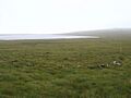
Vord Hill from the west. Funzie Girt dyke runs along the side of the hill at about 90 metres (295 ft) above sea level.
|
|

Funzie Girt
Location in Shetland
|
|
| Coordinates | 60°37′23″N 0°52′05″W / 60.623°N 0.868°W |
Funzie Girt is an ancient wall on Fetlar, an island in Shetland, Scotland. It stretches from north to south across the island. No one knows exactly when it was built, but some think it's from the Neolithic (Stone Age).
This wall is over 4 kilometers (2.5 miles) long. It used to split the island into two nearly equal parts. It's also called the Finnigirt Dyke. Parts of it have disappeared, especially in the south. But you can still see much of it in the wild northern part of the island. It's a big landmark there. We don't know why it was built. There are many old stories about how it was made, and it's even featured in some Shetland folk music.
Contents
What Does the Name Funzie Girt Mean?
The name "Funzie Girt" means "Finns' wall." The Finns were legendary people who lived on the islands before the Norse. People believed they had magic powers. The real people who lived there later were called Picts. The word girt is an old word for a wall or dyke.
The wall might have helped name the island of Fetlar itself. The wall divided the island so clearly that the Norse people saw Fetlar as two separate islands. They called them "Est Isle" (East Island) and "Wast Isle" (West Island). Some people think Fetlar comes from the Old Norse word fetill, which means "strap" or "tie." This would mean Fetlar is like "two islands tied together" by the wall. However, others think fetlar means "shoulder-straps," which doesn't make much sense for an island name. So, Fetlar might be a Norse version of an even older language, possibly Pictish language.
Where Can You Find Funzie Girt?
The Funzie Girt wall was originally about 1 meter (3 feet) wide. It starts on the north shore near cliffs called Muckle Funziegord Geo. It then crosses a nature reserve and disappears near an old enclosure called Whilsa Pund.
The wall reappears at the southern shore of Skutes Water. It is very well-preserved in some areas, like between Riggin of Setter and Rivs Dale. But its path is lost again as it goes around the village of Houbie. It might have reached the south coast of Fetlar near Stack of Billaclett. However, local stories say it ended at the cliffs of Clemmels Geos. If it went all the way, its total length would have been 4 kilometers (2.5 miles) or more.
Other Old Structures Nearby
Whilsa Pund is an old stone enclosure built in a similar way to Funzie Girt. It's shaped like a rectangle, about 293 meters (320 yards) long and 128 meters (140 yards) wide. There are remains of other buildings inside it.
Many other ancient ruins are close to the wall. These include the Bronze Age Hjaltadans stone circle, which is only 6 meters (20 feet) from the wall. There are also three stone circles called Fiddler's Crus. Near the top of Vord Hill, you can find two Neolithic "heel-shaped cairns." These are special burial mounds unique to Shetland.
The village of Funzie, the Bay of Funzie, and Loch of Funzie are about 3 kilometers (2 miles) east of Houbie. They don't seem to have a direct link to the Funzie Girt wall itself.
How Was Funzie Girt Built?

We don't know the exact date when Funzie Girt was built. Some experts suggest it could be from the Mesolithic (Middle Stone Age) or Bronze Age. However, many important sources point to the Neolithic (New Stone Age). In Shetland, the difference between the Neolithic and Bronze Ages isn't always clear. It was likely built before 1000 BC.
Shetland has many old boundary walls, and Funzie Girt is the best example still standing. It divides the island from west to east. It also separates the higher land of Vord Hill from the lower areas. The wall is made from local stones. The largest stones and boulders were placed upright or on their side to form the base.
Building such a huge wall would have taken a lot of human effort. This suggests that many people lived in Shetland during the Neolithic period, perhaps as many as 10,000. The original reason for the wall isn't certain, but it was probably a boundary. In later times, it was used as a property marker. Its massive size is hard to explain given the tools and people available back then. Some have called it a "Bronze Age Berlin Wall," suggesting it might have separated two rival groups.
In contrast, "fealie dykes" were made of turf (grass and soil). An example is near Burn of Feal, less than 0.5 kilometers (0.3 miles) east of Funzie Girt. Even if they had stone bases, these turf walls needed regular repairs. In later times, fences were often added to them to keep animals from crossing.
Protecting Funzie Girt
A strip of land about 1 kilometer (0.6 miles) wide along the east side of the wall was once known as "Houbie." This is now the name of Fetlar's main village. In 1850, a survey of Fetlar was done. At that time, part of Funzie Girt marked the eastern edge of important property boundaries for Russeter, in northern Fetlar. The oldest man on the island then, Andrew Johnson, said he had been on the last "riding" (inspection) of these boundaries in 1820.
The northern part of Funzie Girt is the most complete section. It has been protected as a scheduled monument since December 1957. This means it's an important historical site that must be preserved. The protected area is about 1,828 meters (2,000 yards) long. The land on either side of the wall is not included in this protection. However, the protected area touches the "irregular polygon" (many-sided shape) around Whilsa Pund, which also became protected in 1998.
Funzie Girt in Stories and Music
A large rock called "the Haljer o' Fivlagord" is near the south end of the wall. Fivl means "troll" (or "trow" in Shetland dialect). This suggests people once believed that trolls built the wall. Trolls were also thought to live in a nearby cave on the coast.
One local story is about a farmer at Colbinstoft, west of the wall. He wanted a fence for his farm. He promised that if a fence appeared overnight, he would give his best cow to the Finns. The next morning, the wall had appeared, but his cow was gone! There's also a story that the wall was built because two landowners had an argument.
The Hjaltadans Stone Circle Story

The name Hjaltadans means "limping dance." Local stories say that a fiddler and his wife were dancing at night with trolls. They didn't notice the sun rising. When the sun came up, they all turned to stone. The trolls became the circle of stones, and the two flat stones in the middle are where the humans rested.
Music Inspired by the Wall
Debbie Scott, a fiddle player from Papa Stour, recorded a song called "Da Hill o' Finnigirt – Da Burn o' Finnigirt." It was on her 1985 album The Selkie's Song. The song features guitarist Peerie Willie Johnson. There's also a fiddle tune called the "Muckle Reel O' Finnigirt." This tune went with a dance whose steps are now lost. It was played as a break from more energetic reels.
Images for kids
-
Hjaltadans stone circle
