Papa Stour facts for kids
| Norse name | Papey Stóra |
|---|---|
| Meaning of name | Norse for 'big island of the papar (priests) |
| OS grid reference | HU169607 |
| Coordinates | 60°20′N 1°41′W / 60.33°N 1.68°W |
| Physical geography | |
| Island group | Shetland |
| Area | 828 hectares (3.20 sq mi) |
| Area rank | 59 |
| Highest elevation | Virda Field 87 metres (285 ft) |
| Administration | |
| Sovereign state | United Kingdom |
| Country | Scotland |
| Council area | Shetland Islands |
| Demographics | |
| Population | 15 |
| Population density | 1.8 people/km2 |
| Largest settlement | Biggings |
Papa Stour is a small island in the Shetland Islands of Scotland. It has a very small population, usually around 15 people. Some of these residents moved to the island after an appeal in the 1970s.
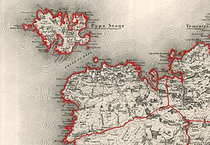
Papa Stour is located west of the main Shetland island. It covers about 828 hectares (3.2 square miles). This makes it the eighth largest island in Shetland. The island's soft volcanic rocks have been shaped by the sea over time. This has created amazing caves, rock stacks, arches, and cliffs.
The island and its waters are home to many different kinds of wildlife. The western part of the island is a special protected area for nature. The seas around Papa Stour are also a protected area.
People have lived on Papa Stour for a very long time. There are ancient burial sites from the Neolithic period. You can also see the remains of a 13th-century house. This house belonged to Duke Hakon during the time the Norsemen lived on the island.
In the 1800s, the island's population grew to over 380 people. This was when a fishing station opened at Crabbaberry. After that, the number of people living on the island slowly went down.
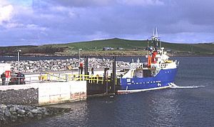
Today, the main village on Papa Stour is Biggings. The Snolda ferry arrives here from West Burrafirth on the Shetland Mainland. Most people on the island work in crofting. This means they farm small pieces of land, especially raising sheep.
Many ships have been wrecked around Papa Stour's coast. The famous poem Da Sang o da Papa Men by Vagaland tells stories of the island's deep-sea fishing past.
Contents
Exploring Papa Stour's Geography
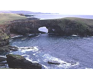
Papa Stour is found at the southwest end of St Magnus Bay. Its coastline is about 34 kilometers (21 miles) long. It has many small bays and four larger 'voes' (sea inlets). Hamna Voe in the south is the most sheltered place for boats. Its cliffs have a natural rock arch.
Housa Voe is in the east. It is the main harbor for the island and where the ferry arrives. Brei Holm and Maiden Stack are two small islands that guard the harbor entrance. Brei Holm is a tidal island. It was once a place where sick people lived until the 1700s.
Maiden Stack has a story from the 1300s. Lord Thorvald Thoresson supposedly built a tiny house on top of it. He wanted to keep his daughter away from men. But the story says she either became pregnant or ran away with a fisherman.
The main village, Biggings, looks over Housa Voe. The land around Biggings is good for farming. The western part of the island has a belt of rocky soil. There is almost no peat (a type of soil used for fuel) on the island. This is because of the volcanic rocks, which make the soil quite fertile.
The highest point on Papa Stour is Virda Field. It is 87 meters (285 feet) high. Its name might come from an Old Norse word meaning 'heap of stones'.
Small Islands and Rocks Nearby
Papa Stour is surrounded by many smaller islands and 'skerries' (rocky islets). Some of these include:
- Aesha Stack
- Boinna Skerry
- Borse Skerry
- Fogla Skerry
- Forewick Holm
- Galti Stacks
- Holm of Melby
- Koda Skerry
- Lyra Skerry
- Skerries of Quidaness
- Skerry of Lambaness
- Sula Stack
- Swat Skerry
- The Horn
- Tiptans Skerry
- Wilma Skerry
The Ve Skerries are about 5 kilometers (3 miles) northwest of Papa Stour. They include Helliogoblo, North Skerry, Ormal, Reaverack, and The Clubb.
In 2008, a man named Stuart Hill claimed the small island of Forewick Holm. He called it "Forvik Island." He argued that it should be a British Crown dependency, not part of the UK. This claim was not accepted by the United Kingdom.
Understanding Papa Stour's Geology
Papa Stour is made of different kinds of rocks. These rocks formed during the Devonian period, millions of years ago. At that time, Scotland was part of a large continent. This continent was located much closer to the equator.
The island's structure is mostly made of ash and lava from ancient volcanoes. There are also layers of solidified volcanic ash and lava called rhyolite. You can also find a Devonian fish bed at Lamba Banks. Large boulders left behind by ancient glaciers are also present.
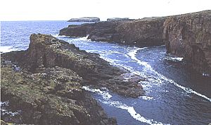
The sea has worn away the soft volcanic rocks. This has created amazing caves, stacks, arches, and cliffs. These are some of the best examples in Britain. The 'Hol o' Bordie' is a cave that goes all the way through the northwest tip of the island. It is 300 meters (980 feet) long and wide enough to row a boat through.
Kirstan (or Christie's) Hole in the southwest is another impressive cave. Part of its roof fell in 1981. 'Francie's Hole' is near Hamna Voe. A writer named John Tudor described it as being like "fairyland" because of its beautiful colors.
In 1953, a dramatic headland called 'Da Horn o Papa' fell into the sea during a storm. The nearby islet of Brei Holm also has caves that small boats can enter when the weather is calm.
Wildlife and Nature on Papa Stour
Many animals can be seen on and around Papa Stour. These include otters, grey seals, killer whales, and harbour porpoises.
Many types of birds also breed on the island. These include:
- Atlantic puffin
- Arctic tern and common tern
- Bonxie and Arctic skua
- northern fulmar
- Common guillemot
- razorbill
- Curlew
- Wheatear
- ringed plover
- great black-backed gull
Many other birds visit the island during their migrations.
The island has many wild flowers. You can find mountain everlasting, spring squill, and eyebright. Heather is also very common.
As mentioned, the west side of the island is a Site of Special Scientific Interest. The seas around Papa Stour are a Special Area of Conservation. These areas protect the island's unique nature. The traditional Shetland pony is still raised here.
A Look at Papa Stour's History
People have lived on Papa Stour since about 3000 BC. There are remains of ancient burial sites called 'heel-shaped cairns'. Not much is known about the time before the Norse people arrived. But when the Norse came, they likely found a religious settlement. The island's name, Papey Stóra, means "Big island of the Papar" (Celtic monks). This name helps tell it apart from Papa Little, another island nearby.
Norse Period on Papa Stour
Papa Stour is mentioned in a very old document from 1299. This document was written in Old Norse. It tells a dramatic story about Duke Hakon Magnusson's house. He later became King Hakon V of Norway.
Near the beach at Housa Voe, there is a circle of stones. These are the remains of a 'ting', which was a local meeting place. A duel happened here, won by Lord Thorvald Thoresson. He was accused of bad behavior in the 1299 document. The remains of Duke Hakon's 13th-century house can still be seen near Housa Voe.
Scottish Rule and Fishing Life
In 1469, Shetland came under Scottish control. However, Norse landowners kept their Papa Stour estates until the 1600s. In the 1500s, traders from Germany came to buy fish from local fishermen.
By the 1700s, two Scottish landowners owned the island. They ran a successful deep-sea fishing business. Fishermen used special six-oared boats called sixareens during the summer months.
The island church was built in 1806. It overlooks Kirk Sand. Some people believe there was an older chapel site nearby. Local stories say that supernatural powers interfered with building the old chapel. They moved the cornerstones overnight to the current church site.
In the 1800s, a fishing station opened at Crabbaberry. The island's population grew to over 360 people. But then, there were fuel shortages and less fishing. This caused the population to drop from the 1870s onwards.
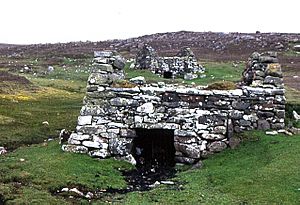
There are good examples of old water mills around Dutch Loch. These were two-story buildings with turf roofs. They were built into banks to allow access to the upper floor where the millstone was. Water falling onto paddles below would turn the millstone. Some of these mills were still used on Papa Stour in the early 1900s.
Papa Stour in the 20th and 21st Centuries
Like many small Scottish islands, Papa Stour's population reached its highest point in the 1800s. Since then, it has seen a big drop in residents. By 1970, the island school had closed. The population was down to just sixteen older people.
However, an advertisement in a magazine helped change this. It offered a farm and five sheep for free to new residents. This brought many people who wanted to move to the island. By 1981, the population had grown to 33. But by 2005, it had fallen again to 20. The school closed once more. By early 2008, the population was only nine after a family left. The 2011 census recorded 15 people living on the island.
How Papa Stour's Population Changed
| Year | Population |
| 1841 | 382 |
| 1871 | 351 |
| 1881 | 254 |
| 1891 | 244 |
| 1931 | 100 |
| Year | Population |
| 1961 | 55 |
| 1981 | 33 |
| 1991 | 33 |
| 2001 | 23 |
| 2011 | 15 |
Shipwrecks Around Papa Stour
Many ships have been wrecked around the coast of Papa Stour. In Hamnavoe, the Tiptans Skerry alone has caused Dutch, French, German, and Norwegian ships to sink.
On March 28, 1930, the trawler Ben Doran sank on the Ve Skerries. This is about 3 miles northwest of Papa Stour. All 9 crew members died in the wreck. Rescue attempts were difficult due to bad weather.
In February 1940, the cargo ship SS Highcliffe ran aground in fog on Forewick Holm. The weather was calm, so only the ship and its cargo were lost. In 1967, the trawler Juniper ran aground near cliffs. The 12 crew members were saved by the Aith lifeboat.
Another shipwreck happened on December 9, 1977. The trawler Elinor Viking sank on the Ve Skerries. The Aith Lifeboat could not get close enough to rescue the crew. A British Airways helicopter from Sumburgh Airport was called. The helicopter crew bravely rescued all the boat's crew. This event led to a lighthouse being built on the skerries in 1979. It also helped create the current Search and Rescue helicopter unit at Sumburgh Airport.
Life and Travel on Papa Stour
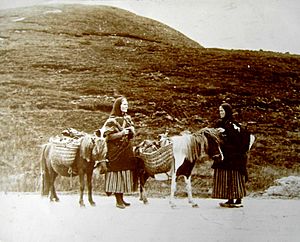
Crofting is the main way of life on Papa Stour. Raising sheep is very important for the island's economy. But people also keep other animals like cattle, pigs, goats, chickens, ducks, and geese. Vegetables are grown too, often in circular walled gardens called 'planti crubs'. These were originally used to grow cabbage seedlings.
Fishing is still done, but on a smaller scale. There is a post office at the pier, but no shop. The island only got mains electricity at the end of the 1900s.
Ferries now travel across the Sound of Papa to West Burrafirth on the Shetland Mainland. The trip takes about 45 minutes. The ferry, called the Snolda, can carry cars. However, there is only one short road on the island. For visiting yachts, the four main voes offer good shelter. But the strong tides in the Sound of Papa need careful navigation.
Airstrip
Culture and Arts on Papa Stour
The Papa Stour sword dance might have come from Norse traditions. It is similar to sword dances in northeast England. A description of this dance appears in the novel The Pirate by Sir Walter Scott.
The writer and journalist John Sands lived on Papa Stour for a while in the late 1800s. George P. S. Peterson, a writer, folklorist, and musician, grew up on Papa Stour.
The island is also the "Papa" in Vagaland's poem Da Sang o da Papa men. This poem is now a popular folk song. The repeating line, 'Rowin Foula Doon!', is very memorable.
The poem describes fishermen rowing their open boats far out to sea. They would row until the high cliffs of Foula could no longer be seen. This meant they were about 96 kilometers (60 miles) west of Papa Stour. The poem also talks about the 'tide-lumps', which are unusually large waves. The poem ends with the fishermen being guided home by the "scent o flooers" across the water. The poem also honors 'Da Horn o Papa', a famous rock formation that collapsed in a storm around the time the poem was written.
|
See also
 In Spanish: Papa Stour para niños
 | Kyle Baker |
 | Joseph Yoakum |
 | Laura Wheeler Waring |
 | Henry Ossawa Tanner |


