Güímar facts for kids
Quick facts for kids
Güímar
|
|||
|---|---|---|---|
|
|||
|
|||
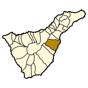
Municipal location in Tenerife
|
|||
| Country | |||
| Autonomous Community | |||
| Province | Tenerife | ||
| Island | Tenerife | ||
| Area | |||
| • Total | 102.9 km2 (39.7 sq mi) | ||
| Elevation
(AMSL)
|
289 m (948 ft) | ||
| Population
(2018)
|
|||
| • Total | 19,739 | ||
| • Density | 191.83/km2 (496.83/sq mi) | ||
| Time zone | UTC+0 (CET) | ||
| • Summer (DST) | UTC+1 (CEST (GMT +1)) | ||
| Postal code |
38500
|
||
| Area code(s) | +34 (Spain) + 922 (Tenerife) | ||
| Climate | BSh | ||
| Website | www.guimar.es | ||
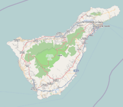
Güímar is a town, valley, and municipality. It is located on the eastern side of Tenerife, one of the Canary Islands in Spain. The municipality covers about 103 square kilometers. It stretches from the mountains to the beaches on the Atlantic Ocean. Güímar shares borders with the towns of La Orotava, Arafo, and Fasnia. About 18,589 people lived there in 2013. The main highway, TF-1, passes through the area.
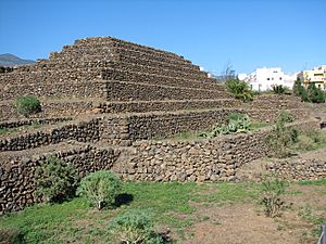
Güímar is well-known for its special pyramids. It is also home to the barranco de Badajoz, a deep ravine. Part of its volcanic landscape is protected as the Nature reserve of Malpaís of Güímar. The highest point in this area is Montaña Grande.
What Does Güímar Mean?
The name Güímar comes from the Guanche language. The Guanche people were the original inhabitants of the Canary Islands. The name is believed to mean 'angle', 'corner', or 'nook'.
A Look at Güímar's History
The first community in Güímar started in the 1500s. It was in the San Juan area, also called Güímar de Arriba. This spot was chosen because it was near the Agua and Chamoco ravines, which had water springs. The first buildings were part of a sugar mill. This mill was started by two brothers, Juan Felipe and Blasino Piombino or Romano.
Güímar's Weather
Güímar has a warm climate all year round. The average temperature is about 19°C (66°F). Summers are warm and sunny, while winters are mild. It does not get very cold. Most of the rain falls in the winter months. Summers are usually very dry.
| Climate data for Güímar (altitude: 289 metres (948 feet)) | |||||||||||||
|---|---|---|---|---|---|---|---|---|---|---|---|---|---|
| Month | Jan | Feb | Mar | Apr | May | Jun | Jul | Aug | Sep | Oct | Nov | Dec | Year |
| Mean daily maximum °C (°F) | — | 18.7 (65.7) |
19.9 (67.8) |
20.7 (69.3) |
21.8 (71.2) |
23.8 (74.8) |
26.3 (79.3) |
27.5 (81.5) |
26.1 (79.0) |
24.5 (76.1) |
21.4 (70.5) |
19.5 (67.1) |
22.4 (72.3) |
| Daily mean °C (°F) | 15.4 (59.7) |
15.6 (60.1) |
16.5 (61.7) |
17.1 (62.8) |
18.1 (64.6) |
20.1 (68.2) |
22.3 (72.1) |
23.1 (73.6) |
22.5 (72.5) |
21.0 (69.8) |
18.4 (65.1) |
16.4 (61.5) |
18.9 (66.0) |
| Mean daily minimum °C (°F) | 12.4 (54.3) |
12.5 (54.5) |
13.1 (55.6) |
13.5 (56.3) |
14.5 (58.1) |
16.5 (61.7) |
18.3 (64.9) |
18.8 (65.8) |
18.9 (66.0) |
17.5 (63.5) |
15.4 (59.7) |
13.4 (56.1) |
15.4 (59.7) |
| Average rainfall mm (inches) | 57 (2.2) |
45 (1.8) |
40 (1.6) |
20 (0.8) |
9 (0.4) |
4 (0.2) |
1 (0.0) |
1 (0.0) |
7 (0.3) |
37 (1.5) |
67 (2.6) |
73 (2.9) |
361 (14.3) |
| Source: Climate-Data.org | |||||||||||||
See Also
 In Spanish: Güímar para niños
 | Delilah Pierce |
 | Gordon Parks |
 | Augusta Savage |
 | Charles Ethan Porter |


