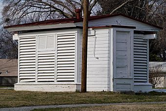
Gaithersburg Latitude Observatory facts for kids
The Gaithersburg Latitude Observatory is a special old building in Gaithersburg, Maryland. It was built in 1899. Its main job was to help scientists measure how the Earth's spinning axis slightly wobbles. This wobble is called the Chandler wobble.
This observatory was one of six similar places around the world. They all worked together to make very exact measurements. In 1989, the observatory was named a National Historic Landmark. This shows how important it was for science and international teamwork. The observatory stopped working in 1982 because new technology, like computers, made human observations unnecessary. Now, the city owns the property.
|
Gaithersburg Latitude Observatory
|
|

Gaithersburg latitude observatory
|
|
| Location | DeSellum Ave., Gaithersburg, Maryland |
|---|---|
| Area | 2.3 acres (0.93 ha) |
| Built | 1899 |
| Built by | Smith, Edwin |
| NRHP reference No. | 85001578 |
Quick facts for kids Significant dates |
|
| Added to NRHP | July 12, 1985 |
| Designated NHL | December 20, 1989 |
Contents
Why the Earth Wobbles: A Scientific Story
The Gaithersburg Latitude Observatory was one of six special observatories built around the world. Their goal was to track a tiny "wobble" in Earth's spin. This wobble changes how far north or south you are, which scientists call "latitude variation."
The first four observatories were built by 1899. They were in:
- Gaithersburg, Maryland, USA
- Cincinnati, Ohio, USA
- Ukiah, California, USA
- Mizusawa, Japan
- Charjui, in what was then Russian Turkestan
- Carloforte, Sardinia, Italy
All these observatories worked together. They watched specific stars to figure out how much the Earth was wobbling. This project was part of the International Polar Motion Service, which started in 1899.
How the Observatory Helped Science
A plaque at the Gaithersburg site explains its importance:
- This small building was key to studying Earth's rotation.
- In 1898, a group called the International Geodetic Association set up these observatories.
- They wanted to measure Earth's wobble by watching stars.
- Gaithersburg was chosen because it was on the same latitude (39° 8' N) as sites in California, Italy, Japan, and the Soviet Union.
- The U.S. Coast and Geodetic Survey managed the American stations.
Clever Building Design
The observatory building itself was designed to help with measurements:
- Its roof could split open in the middle. It moved on tracks to let the telescope see the night sky.
- The outer walls had slats. These helped keep the air inside stable. This stopped outside temperatures from affecting the telescope's accuracy.
- The building was painted white. This helped it reflect heat. Less heat meant less air movement around the telescope at night. Air movement can make stars look blurry.
Scientists used the information gathered here every night until 1982. This data helped them learn about Earth's structure. It also helped spacecraft orbiting our planet and navigating through space.
A second part of the observatory once held a Photographic Zenith Tube. This device took pictures using a special telescope to align and track stars. However, this part of the building is no longer there.
How the Observatory Worked
Edwin Smith, who built the Gaithersburg observatory, was a chief at the U.S. Coast and Geodetic Survey. He had done similar measurements before from his home in Rockville, Maryland.
During its operation, scientists studied twelve groups of stars. Each group had six pairs of stars. Every night, the Gaithersburg station observed two star groups on a set schedule. They then compared their data with the measurements taken by the other five observatories.
The station followed this schedule until 1915. It closed temporarily due to budget cuts. Operations started again in 1932 and continued until 1982. By then, new computer technology and satellite observations made the old methods unnecessary.
Even though it's closed, the data collected by the observatory is still useful. Scientists use it to study:
- Polar motion (how Earth's poles move)
- The physical properties of Earth
- Climate change
- Satellite tracking and navigation
What the Observatory Looks Like
The Gaithersburg Latitude Observatory is on the north side of DeSellum Avenue. It's just north of the Gaithersburg High School campus.
The building is about 13 feet (4 meters) square. It has a small entrance porch on the west side with a slatted roof. There's also a small addition on the east side. The building sits on a foundation made of mortar and fieldstone (natural rocks).
Each end of the roof has a decorative wooden five-pointed star. A metal vent is on top of each roof half, also with a metal star. A system of metal-capped wooden rails lets the building split in the middle. Ropes and pulleys were used to pull the halves apart. Each half moves on its own.
The building has double walls. The inner frame is made of 4x4 wooden beams covered with tongue-and-groove boards. There's a 9-inch (23 cm) space between this inner wall and the outer, slatted wall. This design helped keep the inside temperature stable.
Inside, a double floor surrounds a pyramid-shaped concrete pillar. This pillar supported the telescope and other instruments. A brick house, built in 1947, is about 70 feet (21 meters) south of the observatory. This house was for the caretaker, but it's not part of the historic landmark.
Important Markers and Tools
The area around the observatory was carefully measured and marked.
- The Meridian Mark Pier is about 200 feet (61 meters) south. It was used to line up the zenith telescope perfectly.
- There are five Coast and Geodetic Survey markers on the property.
- One marker, called RM-1, has been used by NOAA for testing related to the Global Positioning Satellite (GPS) system.
 | Calvin Brent |
 | Walter T. Bailey |
 | Martha Cassell Thompson |
 | Alberta Jeannette Cassell |


