Gales Creek (Oregon) facts for kids
Quick facts for kids Gales Creek |
|
|---|---|

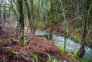
Gales Creek near intersection of Oregon Route 8 and Oregon Route 6
|
|
|
Location of the mouth of Gales Creek in Oregon
|
|
| Country | United States |
| State | Oregon |
| County | Washington County |
| Physical characteristics | |
| Main source | near Round Top Northern Oregon Coast Range 2,387 ft (728 m) 45°40′57″N 123°21′49″W / 45.68250°N 123.36361°W |
| River mouth | Tualatin River 1.6 miles (2.6 km) south of Forest Grove 154 ft (47 m) 45°29′29″N 123°06′08″W / 45.49139°N 123.10222°W |
| Length | 23.5 mi (37.8 km) |
| Basin features | |
| Basin size | 77.9 sq mi (202 km2) |
Gales Creek is a cool stream in Washington County, Oregon, United States. It's like a smaller river that flows into a bigger one. Gales Creek is about 23.5 miles (37.8 km) long. It eventually joins the Tualatin River.
The creek gets its name from Joseph Gale. He was an early settler and a member of the first government in Oregon. He lived near the creek for a while.
Where Does Gales Creek Start?
Gales Creek begins high up on the north side of a mountain called Round Top. This mountain is part of the Northern Oregon Coast Range. The creek starts at an elevation of about 2,387 feet (728 m) above sea level. By the time it reaches the Tualatin River, it has dropped to 154 feet (47 m). That's a big drop!
The Journey of Gales Creek
Gales Creek stays entirely within Washington County. It starts by flowing west, then turns south, and finally heads east. Along its journey, many smaller streams, called tributaries, join it.
- Near the beginning, it flows past Gales Creek Forest Park. Here, Low Divide Creek joins it.
- Further downstream, Oregon Route 6 runs alongside the creek. North Fork Gales Creek and South Fork Gales Creek also add their waters.
- The creek passes under Route 6 a few times. It flows by the Gales Creek Children's Camp.
- It then reaches the community of Glenwood. Here, Beaver Creek flows into Gales Creek.
- After Glenwood, Gales Creek turns southeast. More streams like Bateman Creek, Lyda Creek, and White Creek join in.
- The creek then flows parallel to Oregon Route 8.
- It passes through the community of Gales Creek. Here, Iller Creek joins the main stream.
- As it continues south, Clear Creek, Kelley Creek, and Godfrey Creek all flow into Gales Creek.
- Finally, Gales Creek flows along the southwest side of Forest Grove. It passes under the Oregon Route 47 Bridge.
- A little further on, it goes under a railroad bridge. After about 1.5 miles (2.4 km) more, it empties into the Tualatin River. The Tualatin River then flows into the Willamette River.
How Much Water Flows in Gales Creek?
Scientists keep an eye on how much water flows in Gales Creek. They have a special measuring station near the Route 47 bridge in Forest Grove. This station helps them understand the creek's flow.
In 2008, the average amount of water flowing in the creek was about 202 cubic feet per second (5.7 m3/s).
- The most water recorded was on January 11, 2008. It was 1,880 cubic feet per second (53 m3/s)! This happens when there's a lot of rain or snowmelt.
- The least amount of water was on September 17, 2008. It was only 6.4 cubic feet per second (0.18 m3/s). This is usually during dry summer months.
 | James B. Knighten |
 | Azellia White |
 | Willa Brown |


