Garnat-sur-Engièvre facts for kids
Quick facts for kids
Garnat-sur-Engièvre
|
|
|---|---|

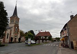
The main road in Garnat-sur-Engièvre
|
|
| Country | France |
| Region | Auvergne-Rhône-Alpes |
| Department | Allier |
| Arrondissement | Moulins |
| Canton | Dompierre-sur-Besbre |
| Intercommunality | Pays de Chevagnes en Sologne Bourbonnaise |
| Area
1
|
18.74 km2 (7.24 sq mi) |
| Population
(Jan. 2019)
|
710 |
| • Density | 37.89/km2 (98.1/sq mi) |
| Time zone | UTC+01:00 (CET) |
| • Summer (DST) | UTC+02:00 (CEST) |
| INSEE/Postal code |
03120 /03230
|
| Elevation | 202–242 m (663–794 ft) (avg. 200 m or 660 ft) |
| 1 French Land Register data, which excludes lakes, ponds, glaciers > 1 km2 (0.386 sq mi or 247 acres) and river estuaries. | |
Garnat-sur-Engièvre is a small and charming commune located in the center of France. It is part of the Allier department. A commune is like a local town or village area with its own government.
Contents
About Garnat-sur-Engièvre
Garnat-sur-Engièvre is a peaceful place. It is known for its quiet streets and natural surroundings. The commune is named after the Engièvre river. This river flows nearby and adds to the area's beauty.
Where is Garnat-sur-Engièvre Located?
Garnat-sur-Engièvre is found in the Allier department. This department is in the Auvergne-Rhône-Alpes region of central France. The nearest large town is Moulins. Moulins is the capital of the Allier department.
- Department: Allier
- Arrondissement: Moulins
- Canton: Dompierre-sur-Besbre
The commune's exact location can be found using its coordinates. These are 46.6344 degrees north and 3.6636 degrees east. This helps people find it on a map.
How Many People Live Here?
As of January 2019, about 710 people lived in Garnat-sur-Engièvre. This makes it a small community. The number of people living in a commune is called its population. This number helps us understand the size of the community.
Who is the Mayor?
The mayor of Garnat-sur-Engièvre is Joël Lamouche. He was elected to serve from 2014 to 2020. The mayor is the head of the local government. They help manage the commune's daily life. This includes things like local services and public spaces.
What is the Area and Elevation?
Garnat-sur-Engièvre covers an area of 18.74 square kilometers. This is about 7.23 square miles. The commune's elevation, or height above sea level, varies. It ranges from 202 meters (663 feet) to 242 meters (794 feet). The average elevation is around 200 meters (656 feet).
Local Government and Services
Like all French communes, Garnat-sur-Engièvre has a local council. This council works with the mayor. They make decisions about the commune's future. These decisions affect the people who live there.
The commune is also part of a larger group. This group is called "Pays de Chevagnes en Sologne Bourbonnaise." This helps different communes work together. They can share resources and plan for the region.
See also

- In Spanish: Garnat-sur-Engièvre para niños


