Garristown facts for kids
Quick facts for kids
Garristown
Irish: Baile Gháire
|
|
|---|---|
|
Village
|
|

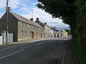
Houses on Garristown's main street
|
|
| Country | Ireland |
| Province | Leinster |
| County | County Dublin |
| Local government area | Fingal |
| Elevation | 120 m (390 ft) |
| Population
(2022)
|
619 |
| Time zone | UTC±0 (WET) |
| • Summer (DST) | UTC+1 (IST) |
| Eircode routing key |
A42
|
| Telephone area code | +353(0)1 |
| Irish Grid Reference | O071587 |
Garristown (which means Baile Gháire in Irish) is a small village in County Dublin, Ireland. It is also a historic area called a civil parish within the old barony of Balrothery West. In 2022, a count showed that 619 people lived in Garristown. This was a big jump from 2002, when only 289 people lived there.
Contents
Where is Garristown Located?
Garristown is about 18 kilometers (11 miles) north of Swords. It is also around 7 kilometers (4 miles) northeast of Ashbourne. The village is in a hilly area. From west to east, the land slopes downwards. You can see views of the hills near Naul. The center of Garristown is 120 meters (394 feet) above sea level.
A Look at Garristown's Past
Garristown has a long history. Records from the year 1200 show that the Archbishop of Dublin gave the church in Garristown to a priory (a type of monastery). Later, in 1318, a man named William de Bardelby, who became an important judge, was the local priest.
By 1607, Garristown had a windmill and two other mills. There were also about 326 acres (1.3 square kilometers) of land around the village. The village was officially recorded in a survey in 1654. The old medieval church was later replaced by a new one.
The way Garristown's streets are laid out today is very similar to how they looked on a map from 1746. In 1837, the village had 741 people. The wider area around it had 2,801 people. At that time, Garristown had a police station and a place where people could get medicine. There was also a windmill and two churches: one for the Church of Ireland and one for the Roman Catholic Church. The Catholic church was built in 1828. There was a school for boys and two private schools. The village also held three fairs each year. The area had natural resources like stone and peat (a type of fuel).
A new Roman Catholic church, called the Church of Assumption, was officially opened on June 10, 1906.
What Can You Find in Garristown?
Garristown's main street runs from north to south. On the western side, there is a nice area with trees. The center of the village is where Main Street meets Naul Road. The police station building in the village center was built in the 1800s. The Carnegie library is still open today and was built in the early 1900s. It was updated in the 2000s.
Garristown also has a primary school and a community center. The community center used to be a secondary school. After it closed, the community council bought it. They turned it into a large hall and other useful rooms. Many local groups use this center. These include the local branch of the Irish Countrywomen's Association, scout groups, and the youth club. You can also still see the base of the old windmill.
Other places in the village include a pub, a butcher's shop, a small supermarket, and a hair salon. There is also a service station and a Garda station (police station).
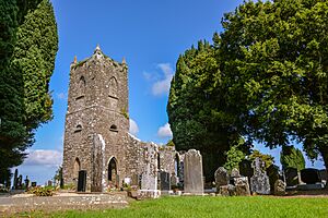
The local Roman Catholic church is called the Church of the Assumption. It is part of the Garristown parish. There is also an old Church of Ireland church and a cemetery.
Sports and Clubs
Garristown has its own GAA club called Garristown GFC. Their sports grounds are to the east of the village. The club has 11 teams and a new clubhouse with a small gym.
Other local groups include the Garristown Gun Club and the Garristown Historical Society. There is also the Arena Airsoft Club for those who enjoy airsoft games.
A famous Dublin Gaelic footballer, Dean Rock, comes from the Garristown area.
How Garristown is Governed
Garristown is part of the local government area called Fingal. It is also in the Dáil constituency of Dublin Fingal. This means that people in Garristown vote for representatives in the Irish parliament. In 2005, the Fingal County Council made plans for an area just east of the village.


