Gentryville, Indiana facts for kids
Quick facts for kids
Gentryville, Indiana
|
|
|---|---|
 |
|

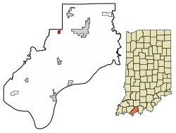
Location of Gentryville in Spencer County, Indiana
|
|
| Country | United States |
| State | Indiana |
| County | Spencer |
| Township | Jackson |
| Area | |
| • Total | 0.40 sq mi (1.02 km2) |
| • Land | 0.39 sq mi (1.02 km2) |
| • Water | 0.00 sq mi (0.00 km2) 0% |
| Elevation | 466 ft (142 m) |
| Population
(2020)
|
|
| • Total | 243 |
| • Density | 616.75/sq mi (238.06/km2) |
| Time zone | UTC-6 (CST) |
| • Summer (DST) | UTC-5 (CDT) |
| ZIP code |
47537
|
| Area code(s) | 812 |
| FIPS code | 18-27270 |
| GNIS feature ID | 2396957 |
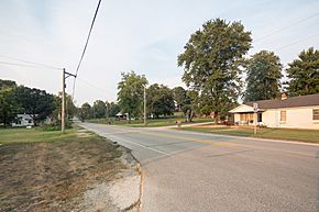
Gentryville is a small town located in Spencer County, in the state of Indiana, United States. It is part of Jackson Township. In 2020, about 243 people lived there.
Contents
A Look Back: Gentryville's History
Gentryville was officially planned and mapped out in December 1854. It was named after James Gentry. He was an early settler and a local businessman in the area.
The town's post office has been open for a very long time. It started operating way back in 1826.
Where is Gentryville?
Gentryville is located in Indiana. According to information from 2010, the town covers a total area of about 0.39 square miles (1.02 square kilometers). All of this area is land.
Who Lives in Gentryville?
| Historical population | |||
|---|---|---|---|
| Census | Pop. | %± | |
| 1900 | 464 | — | |
| 1910 | 383 | −17.5% | |
| 1920 | 291 | −24.0% | |
| 1930 | 271 | −6.9% | |
| 1940 | 258 | −4.8% | |
| 1950 | 234 | −9.3% | |
| 1960 | 297 | 26.9% | |
| 1970 | 281 | −5.4% | |
| 1980 | 299 | 6.4% | |
| 1990 | 277 | −7.4% | |
| 2000 | 262 | −5.4% | |
| 2010 | 268 | 2.3% | |
| 2020 | 243 | −9.3% | |
| U.S. Decennial Census | |||
Gentryville's Population in 2010
In 2010, a survey called the census counted 268 people living in Gentryville. These people lived in 110 different homes, and 79 of those were families. The town had about 687 people per square mile.
Most of the people living in Gentryville were White (95.9%). A smaller number were African American (1.1%) or Native American (1.9%). Some people were from other races (0.7%) or a mix of two or more races (0.4%). About 1.1% of the population identified as Hispanic or Latino.
Out of the 110 homes, about 27% had children under 18 living there. More than half (55.5%) were married couples living together. About 8% of homes had a female head of household without a husband. Another 8% had a male head of household without a wife. About 28% of homes were not families.
The average age of people in Gentryville was 44.4 years old. About 19% of residents were under 18. About 8% were between 18 and 24 years old. People aged 25 to 44 made up about 24% of the population. The largest group, about 32.5%, was between 45 and 64 years old. Finally, about 16% of residents were 65 or older. Slightly more than half of the population (52.2%) was female, and 47.8% was male.
Roads and Travel
In March 2011, a major change happened to the roads near Gentryville. A new four-lane highway, U.S. 231, was built. It is now about four miles east of the town.
However, Indiana 62 and Indiana 162 still go right through Gentryville. Indiana 62 now uses the old path of U.S. 231.
Schools in Gentryville
Gentryville is part of the North Spencer County School Corporation. This is the group that manages the schools in the area.
Before 1948, Gentryville had its very own high school. The school colors were green and white, and their sports team mascot was the pirates! But in 1948, the school district was closed down. Some students went to the Chrisney school district, and others went to the Dale School District. Later, in 1972, the high schools from Chrisney and Dale joined together.
See also
 In Spanish: Gentryville (Indiana) para niños
 | Shirley Ann Jackson |
 | Garett Morgan |
 | J. Ernest Wilkins Jr. |
 | Elijah McCoy |

